Log in
All resources
Create a design
27,441 Free Images of Maps
maps from the earth and its inhabitants, vol. iv
bibliothèque nationale de france
eran laor cartographic collection
latin-language maps
maps from the earth and its inhabitants, vol. xii
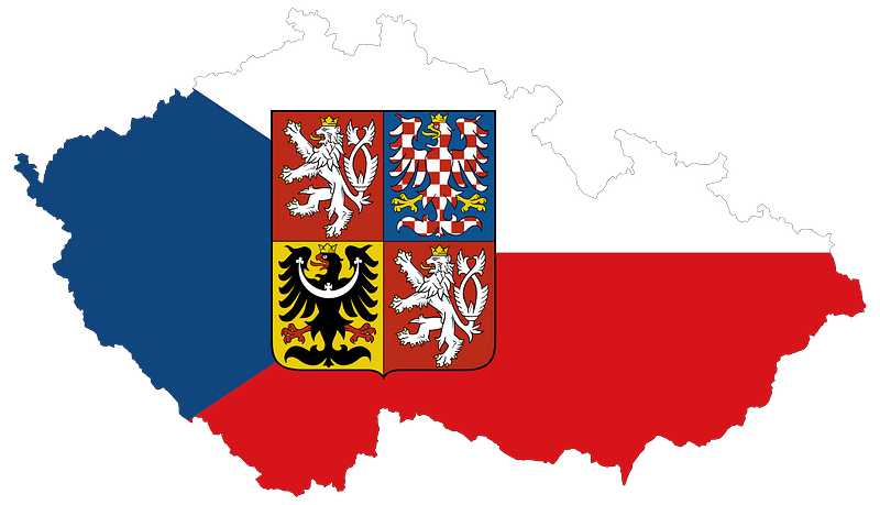
flag
baroque
maps from the earth and its inhabitants, vol. x
maps from the earth and its inhabitants, vol. xvi
maps from the earth and its inhabitants, vol. vi
maps from the earth and its inhabitants, vol. iv
19th-century maps of gloucestershire
maps from the earth and its inhabitants, vol. iv
old maps of the shetland islands
maps from the earth and its inhabitants, vol. iv
old maps of portsmouth
maps from the earth and its inhabitants, vol. xii
old maps of cameroon
maps from the earth and its inhabitants, vol. xiii
old maps of luanda
maps from the earth and its inhabitants, vol. x
linguistic maps of africa
maps from the earth and its inhabitants, vol. xii
old maps of the canary islands
maps from the earth and its inhabitants, vol. iv
old maps of hartlepool
maps from the earth and its inhabitants, vol. iv
old maps of glasgow
maps from the earth and its inhabitants, vol. ix
maps of the hindu kush
maps from the earth and its inhabitants, vol. xii
19th-century maps of the azores
maps from the earth and its inhabitants, vol. x
topographic maps of africa
maps from the earth and its inhabitants, vol. x
religion maps of africa
maps from the earth and its inhabitants, vol. iv
old maps of salisbury
maps from the earth and its inhabitants, vol. xvi
topographic maps of mexico
maps from the earth and its inhabitants, vol. xvii
old maps of martha's vineyard
maps from the earth and its inhabitants, vol. iv
maps of the british isles
maps from the earth and its inhabitants, vol. iv
19th-century maps of lancashire
maps from the earth and its inhabitants, vol. v
old maps of the black sea
maps from the earth and its inhabitants, vol. viii
topographic maps of sri lanka
maps from the earth and its inhabitants, vol. xvi
19th-century maps of guadeloupe
maps from the earth and its inhabitants, vol. iv
old maps of portsmouth
maps from the earth and its inhabitants, vol. ix
1870s maps of palestine
maps from the earth and its inhabitants, vol. xviii
maps of weather and climate of south america
maps from the earth and its inhabitants, vol. vi
ethnographic maps of asia
maps from the earth and its inhabitants, vol. iv
maps of st kilda
maps from the earth and its inhabitants, vol. xvi
19th-century maps of guadeloupe
maps from the earth and its inhabitants, vol. xv
19th-century maps of quebec
maps from the earth and its inhabitants, vol. xviii
old maps of caracas
maps from the earth and its inhabitants, vol. iv
maps of the scilly islands
maps from the earth and its inhabitants, vol. iv
old maps of lindisfarne
maps from the earth and its inhabitants, vol. iii
old maps of rijeka
maps from the earth and its inhabitants, vol. xii
maps of the congo river
maps from the earth and its inhabitants, vol. iv
old maps of perth, scotland
maps from the earth and its inhabitants, vol. xii
old maps of tenerife
maps from the earth and its inhabitants, vol. vi
bathymetric maps of the caspian sea
maps from the earth and its inhabitants, vol. vii
old maps of xi'an
maps from the earth and its inhabitants, vol. iii
population density maps of europe
maps from the earth and its inhabitants, vol. iv
old maps of shrewsbury
maps from the earth and its inhabitants, vol. v
19th-century maps of stockholm
maps from the earth and its inhabitants, vol. vi
atmospheric pressure maps
maps from the earth and its inhabitants, vol. xv
maps of ocean currents
maps from the earth and its inhabitants, vol. iv
19th-century maps of the isle of wight
maps from the earth and its inhabitants, vol. iv
old maps of the orkney islands
maps from the earth and its inhabitants, vol. xvii
19th-century maps of san francisco
eran laor cartographic collection
richard william seale
eran laor cartographic collection
bolognino zaltieri
georg balthasar probst (1732-1801)
eran laor cartographic collection
beschreibung der städt der welt - braun & hogenberg - btv1b52512111k
maps of mons (hainaut) by braun & hogenberg
eran laor cartographic collection
richard william seale
eran laor cartographic collection
willem albert bachiene
maps of portugal by fernando álvares seco
kingdom of the algarve
merian mainz trier köln
baroque
old maps of chania
1651 in chania
illustrated title pages from the netherlands
joan blaeu
emmerich am rhein in art
atlas beudeker
sanson maps of north america
maps by nicolas sanson
maps of ancient israel by philippe de la rué
eran laor cartographic collection
atlas ou representation du monde universel t. 1 (1633)
17th-century double hemisphere world maps
guillaume sanson
1674 maps
maps of alcanerilla by braun & hogenberg
context files from gallica
atlas géographique des quatre parties du monde (delisle)
18th-century maps of the iberian peninsula
1750s maps of the netherlands
18th-century maps of zeeland
führer durch dalmatien (1899)
salona
maps from university of amsterdam special collections
atlas der neederlanden
maps from university of amsterdam special collections
atlas der neederlanden
eran laor cartographic collection
joseph schwarz
mechanicsville historic district
maps in the library of congress
old maps of the sea of galilee
french-language maps
eran laor cartographic collection
willem blaeu
17th-century maps of the americas
maps from gallica
map of paris by braun & hogenberg - derivative files
rue des archives (paris)
eran laor cartographic collection
alexis-hubert jaillot
old maps of smolensk
baroque
greifswald in the 17th century
old maps of greifswald
1680s maps of rhineland-palatinate
maps of vangiones by sanson
maps by pieter mortier
maps from gallica
maps by louis brion de la tour
1782 maps of the caribbean
maps of spain by tomas lopez
old maps of menorca
maps by pieter mortier
maps from gallica
1760s maps of the philippines
baroque painting
18th-century maps of north africa
maps by tomas lopez
maps of france by hendrik hondius
17th-century maps of xaintonge
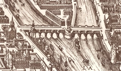
map of paris by claes jansz. visscher - derivate files
historical images of pont neuf
old maps of saxony
pieter schenk (ii)
algiers in the 19th century
old maps of algiers
william smith (lexicographer)
maps of nineveh
maps from the earth and its inhabitants, vol. xiii
maps of africa
maps in the topographia austriacarum (merian)
baroque
engravings of topographia saxoniae inferioris
baroque
curt teich postcard archives
king city, missouri
maps from the earth and its inhabitants, vol. xii
africa in the 1890s
portolan charts by willem and johannes blaeu
dutch east india company
maps
flag
17th-century maps of amsterdam
dirck cornelisz. swart
maps
flag
maps
flag
maps
flag
maps
flag
maps
flag
9401 - 9500 of 27,441
Next page
/ 275