EMMERYCK, Joan Blaeu, 1649

EMMERYCK, Joan Blaeu, 1649

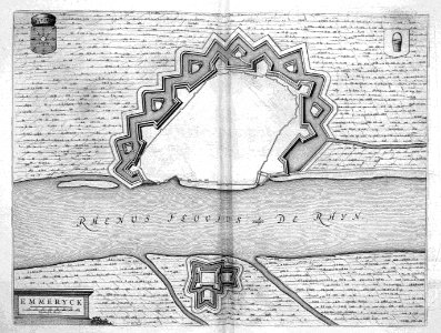
This map of the german city emmerik was published in joan blaeus (1596-1673) town books of the netherlands in 1649. In this atlas, blaeu published more than 200 city plans of dutch towns and fortifications. This map was included in the first volume of the town books of the netherlands which was dedicated to the northern netherlands. Object Type: print. Date: 1649. Place of creation: Amsterdam. Dimensions: 38,5 x 51 cm. Medium: copper engraving print. Collection: British Library. Atlas Beudeker-C9E10 102 24J-EMMERYCK
Edit image
Published by:
Creazilla
Author: Joan BlaeuSource: commons.wikimedia.org

Loading...

0 downloads
Loading...
atlas beudekeremmerich am rhein in artmaps by willem and johannes blaeucopper engraving printbritish libraryjoan blaeu

MORE LIKE THIS

Creazilla logo
Over 10 million free graphic resources for content creators and designers.
© 2018 - 2025 Creazilla
Our resourcesAll imagesPhotosDigital illustrationsClipartIconsPNG ImagesEmojisSilhouettesTraditional Art3D ModelsVectorsFontsColor namesColor palettesGradientsAudioAnimationVideosTemplates
InformationAbout CreazillaTerms of useTech teamPrivacy policyLicence Information
FeedbackContact Us