Log in
All resources
Create a design
27,441 Free Images of Maps
eran laor cartographic collection
john rocque
john rocque 1746 london map (a1-h3)
joan blaeu
copper engraving print
latin-language maps
dutch-language maps
british library
gemeente atlas van nederland - north holland
1860s maps of north holland
john rocque 1746 london map (a1-h3)
john rocque
john rocque 1746 london map (a1-h3)
john rocque
john rocque 1746 london map (a1-h3)
john rocque
john rocque 1746 london map (a1-h3)
john rocque
john rocque 1746 london map (a1-h3)
john rocque
john rocque 1746 london map (a1-h3)
john rocque
john rocque 1746 london map (a1-h3)
john rocque
john rocque 1746 london map (a1-h3)
john rocque
john rocque 1746 london map (a1-h3)
john rocque
john rocque 1746 london map (a1-h3)
john rocque
john rocque 1746 london map (a1-h3)
john rocque
maps of the dutch east india company - india
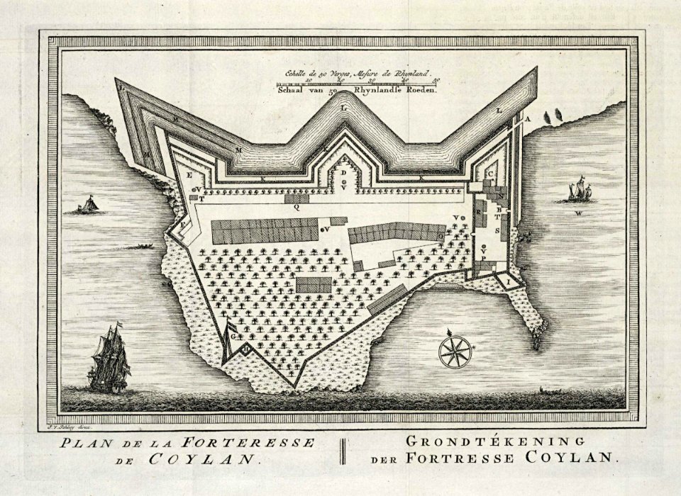
st. thomas fort, tangasseri
atlas van der hagen (volume 3)
atlas van der hagen
bijou theatre (knoxville, tennessee)
maps in the library of congress
landkreis eichsfeld in the 17th century
maps from gallica
aerial views of amherst, massachusetts
town maps by l. r. burleigh
picturesque tour from geneva to milan, by way of the simplon (1820)
maps from the mechanical curator collection
kaart van suriname naar opmetingen gedaan in de jaren 1860-1879
albina, suriname
korte beschryvinghe (1686)
maps of tabarka
barkowo, lower silesian voivodeship
18th-century maps of silesia
bibliothèque municipale de reims, rès. g 152
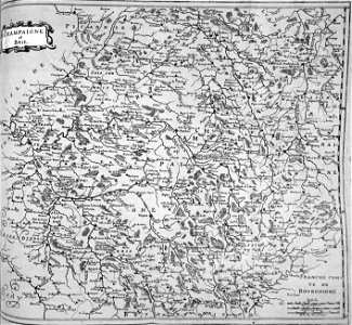
maps of champagne-ardenne
maximilian friedrich weyhe
romanticism
maps by wilhelm maximilian carpelan
zetterbergsvägen
symbolism
drawings
cartes de franz schrader
1894 maps of france
maps of edinburgh by braun & hogenberg
18th-century maps of scotland
chicago and the midwest, newberry library
rand mcnally
gemeente atlas van nederland - north holland
maps of marken (waterland)
gemeente atlas van nederland - north holland
old maps of monnickendam
maps of delft by braun & hogenberg
media from tu delft
historical maps of crema
porta serio
bibliothèque municipale de reims, rès. g 152
maps of moyenvic
1640s maps of abkhazia
1640s maps of georgia
palace of nations
maps of geneva
gemeente atlas van nederland - north holland
old maps of enkhuizen
maps from the earth and its inhabitants, vol. xi
africa in the 1890s
gemeente atlas van nederland - north holland
maps of jisp
chicago and the midwest, newberry library
surveying in united states
maps from the earth and its inhabitants, vol. x
geography of egypt
maps from the earth and its inhabitants, vol. xi
algeria in the 1800s
maps from the earth and its inhabitants, vol. xi
africa in the 1890s
historical maps of crema
porta ombriano
gemeente atlas van nederland - north holland
old maps of purmerend
maps by willem and johannes blaeu
old maps of delfzijl
maps from the earth and its inhabitants, vol. xiii
africa in the 1890s
maps from the earth and its inhabitants, vol. xi
africa in the 1890s
kurtze beschreibung von republick venedig
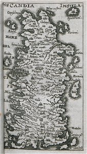
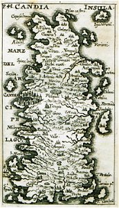
candia in the 17th century
kurtze beschreibung von republick venedig
candia in the 17th century
atlas maior, vol 11 (asia) - joan blaeu, 1667 - bl 114.h(star).11
1667 maps
the turkish empire in europe, asia and africa (1752)
1730s maps of the ottoman empire
old maps of the strait of gibraltar
a school geography (1898) by bird
geological maps of pennsylvania
1885 maps of philadelphia
malebné cesty po praze (1884)
old maps of czechia
atlas maior, vol 10 (spain and africa) - joan blaeu, 1667 - bl 114.h(star).10
1667 maps
atlas maior, vol 10 (spain and africa) - joan blaeu, 1667 - bl 114.h(star).10
1667 maps
atlas maior, vol 9 (italy) - joan blaeu, 1667 - bl 114.h(star).9
1667 maps of italy
geological maps of pennsylvania
1885 maps of philadelphia
le neptune francois
1700 maps of cuba
atlas maior, vol 4 (netherlands) - joan blaeu, 1667 - bl 114.h(star).4
1667 maps
atlas maior, vol 6 (scotland and ireland) - joan blaeu, 1667 - bl 114.h(star).6
1667 maps
prints of cartouches in the rijksmuseum amsterdam
maps in the rijksmuseum amsterdam
prints of cartouches in the rijksmuseum amsterdam
maps in the rijksmuseum amsterdam
eran laor cartographic collection
baroque
old maps of south africa
emil holub
maps by wilhelm maximilian carpelan
slättens gård, mälarhöjden
john rocque's 1748 map of london and adjacent country
bibliothèque nationale de france
1890s maps of south africa
emil holub
maps of goa by linschoten
maps
maps in the aguirra collection
1900s maps of brazil
maps from university of amsterdam special collections
atlas der neederlanden
engravings of topographia saxoniae inferioris
baroque
eran laor cartographic collection
tranquillo mollo
eran laor cartographic collection
tranquillo mollo
house of arenberg
parks in belgium
maps in the stadsarchief amsterdam
die grund-regeln der bau-kunst
jodocus hondius ii, nova totius terrarum orbis geographica ac hydrographica tabula, 1636
maps in the library of congress
maps of eger by braun & hogenberg
eger
eran laor cartographic collection
romeyn de hooghe
eran laor cartographic collection
german renaissance,humanism
eran laor cartographic collection
gerard de jode
eran laor cartographic collection
cornelis de bruyn
eran laor cartographic collection
cornelis de bruyn
eran laor cartographic collection
martin engelbrecht
eran laor cartographic collection
german renaissance,humanism
eran laor cartographic collection
william hole (engraver)
eran laor cartographic collection
romanticism
eran laor cartographic collection
german renaissance,humanism
eran laor cartographic collection
german renaissance,humanism
eran laor cartographic collection
emanuel bowen
maps of utrecht (city) city walls
old maps of utrecht (city)
eran laor cartographic collection
cornelis de bruyn
eran laor cartographic collection
william hole (engraver)
eran laor cartographic collection
cornelis de bruyn
breda, netherlands in the 17th century
old maps of north brabant
eran laor cartographic collection
joan blaeu
eran laor cartographic collection
cornelis de bruyn
eran laor cartographic collection
joan blaeu
french-language maps
daniel de la feuille
maps of the battle of the nile
battle of alexandria
maps from the earth and its inhabitants, vol. vi
alay district
8201 - 8300 of 27,441
Next page
/ 275