Log in
All resources
Create a design
27,441 Free Images of Maps
bibliothèque nationale de france
beschreibung und contrafactur der vornembster stät der welt, liber primus civitates orbis terrarum
drawings in the museu antônio parreiras
map - museu antônio parreiras
antônio parreiras
eran laor cartographic collection
paper and graphite
tresor des cartes geographiques (1659)
baroque
latin-language maps
tresor des cartes geographiques (1659)
1650s maps of the tsardom of russia
tresor des cartes geographiques (1659)
maps facing east
beschreibung und contrafactur der vornembster stät der welt, liber primus civitates orbis terrarum
maps of nördlingen by braun & hogenberg
beschreibung und contrafactur der vornembster stät der welt, liber primus civitates orbis terrarum
maps of 's-hertogenbosch by braun & hogenberg
beschreibung und contrafactur der vornembster stät der welt, liber primus civitates orbis terrarum
maps of lindau (bodensee) by braun & hogenberg
beschreibung und contrafactur der vornembster stät der welt, liber primus civitates orbis terrarum
maps of wesel by braun & hogenberg
tresor des cartes geographiques (1659)
17th-century maps of siberia
beschreibung und contrafactur der vornembster stät der welt, liber primus civitates orbis terrarum
maps of kozhikode by braun & hogenberg
beschreibung und contrafactur der vornembster stät der welt, liber primus civitates orbis terrarum
maps of 's-hertogenbosch by braun & hogenberg
beschreibung und contrafactur der vornembster stät der welt, liber primus civitates orbis terrarum
maps of osnabrück by braun & hogenberg
beschreibung und contrafactur der vornembster stät der welt, liber primus civitates orbis terrarum
maps of azemmour by braun & hogenberg
tresor des cartes geographiques (1659)
old maps of tunis
1782 maps of the caribbean
maps by juan lopez
beschreibung und contrafactur der vornembster stät der welt, liber primus civitates orbis terrarum
maps of safi by braun & hogenberg
beschreibung und contrafactur der vornembster stät der welt, liber primus civitates orbis terrarum
maps of aden by braun & hogenberg
1640s maps of the tsardom of russia
sigismund's map of moscow
beschreibung und contrafactur der vornembster stät der welt, liber primus civitates orbis terrarum
maps of heidelberg by braun & hogenberg
beschreibung und contrafactur der vornembster stät der welt, liber primus civitates orbis terrarum
maps of weimar by braun & hogenberg
hamburgische elbkarte von melchior lorichs
parts of old maps of hamburg
hamburgische elbkarte von melchior lorichs
parts of old maps of hamburg
tresor des cartes geographiques (1659)
1650s maps of the world
eran laor cartographic collection
german renaissance,humanism
eran laor cartographic collection
german renaissance,humanism
eran laor cartographic collection
thesaurus philopoliticus
gemeente atlas van nederland - groningen
old maps of groningen (city)
maps of the turks and caicos islands
1782 maps of the caribbean
fra mauro map derivative works
l’homme et la terre tome 4
old maps of valletta
baroque
st thomas' hospital (southwark)
guy's hospital
engravings by matthäus merian
baroque
cartouches by sanson family
monsters on maps
siberia and the exile system vol 1 (book)
19th-century maps of siberia
fra mauro map derivative works
a map of the british empire in america with the french and spanish settlements adjacent thereto
compass roses on maps
details of old maps of moscow
antey theatre
dutch 18th-century paintings in the rijksmuseum amsterdam
august christian hauck
old maps of salvador (bahia)
jacob van meurs
maps in the library of congress
1765 maps
bibliothèque nationale de france
propaganda map
bibliothèque nationale de france
propaganda map
collections of the kobe city museum
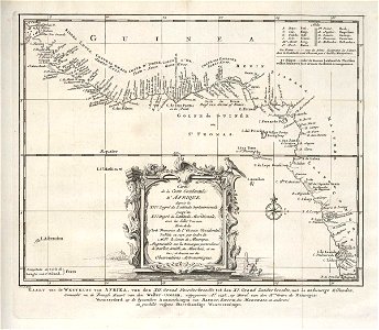
18th-century maps of africa
gemeente atlas van nederland - south holland
1860s maps of south holland
maps from the mechanical curator collection
realism
1680s maps of north america
hugo allardt
drawings in the museu antônio parreiras
paper and graphite
drawings in the museu antônio parreiras
paper and graphite
maps by jacques chiquet
1719 maps of africa
drawings in the museu antônio parreiras
paper and graphite
drawings in the museu antônio parreiras
paper and charcoal
old maps of capitanata
puglia settentrionale
reconstructions of old maps
german renaissance
drawings in the museu antônio parreiras
paper and graphite
reconstructions of old maps
german renaissance
maps in the staats- und universitätsbibliothek hamburg
1870 maps of hamburg
drawings in the museu antônio parreiras
paper and charcoal
atlas geographico del reyno de españa e islas adjacentes (1757)
1757 maps of spain
drawings in the museu antônio parreiras
paper and graphite
drawings in the museu antônio parreiras
paper and graphite
old maps of fictional countries
bernard sleigh
details of old maps of düsseldorf
pharus-plan
maps of gouda by braun & hogenberg
hollandse ijssel in gouda
description de l'universe
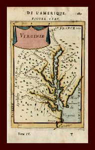
old maps of virginia
description de l'universe
old maps of greece
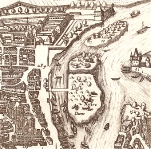
île notre-dame (paris)
île aux vaches
maps of brussels city walls
old maps of brussels
17th-century maps of amsterdam
maps by nicolaes visscher i
maps from university of amsterdam special collections
atlas der neederlanden
maps by jean-baptiste bourguignon d'anville
18th-century maps of western europe
maps of chimay by braun & hogenberg
maps of chimay city walls
maps by willem and johannes blaeu
1630s maps of the world
maps of the west-indische compagnie
1747 maps of africa
maps in the rijksmuseum amsterdam
published by frans buffa & zonen
16th-century maps of istanbul
ottoman istanbul in art
eran laor cartographic collection
baroque
danubius pannonico-mysicus
1720s maps of hungary
maps from the earth and its inhabitants, vol. vi
1891 maps of georgia
merian hassiae
baroque
palatinatus rheni (merian)
baroque
david rumsey historical map collection
1790s maps of the holy roman empire
maps of venice by braun & hogenberg
16th-century maps of venice
maps of cefala by braun & hogenberg
national museum of tanzania
1794 maps of the holy roman empire
english-language maps of europe
the cruise of the alice may in the gulf of st. lawrence and adjacent waters (1885) by benjamin
maps from the mechanical curator collection
map of amsterdam, 1544
agnietenkapel
orbispictus - extracted images
1650s maps of the world
romanticism,symbolism,romantic nationalism
maps of karelia
maps of the west-indische compagnie
1671
maps by willem and johannes blaeu
17th-century maps of moscow
maps of coimbra by braun & hogenberg
1598 engravings
media contributed by university of illinois urbana-champaign university library
renaissance
eran laor cartographic collection
joris hoefnagel
maps from university of amsterdam special collections
atlas der neederlanden
eran laor cartographic collection
willem albert bachiene
bruxella nobilissima brabantiae civitas restauratum an° 1748
abraham dircksz. santvoort
eran laor cartographic collection
willem albert bachiene
dheulland map of paris
details of old maps of leipzig
adolf eltzner
maps by willem and johannes blaeu
old maps of damme
historical maps of the county of kłodzko
coats of arms of county of kladsko
maps of midden-delfland
old maps of delfland
6101 - 6200 of 27,441
Next page
/ 275