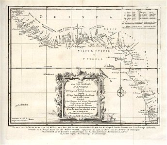
Map of the west coast of Africa, from 12 degrees north latitude to 11 degrees south latitude, Jakob van der Schley, circa 1747
Map of the west coast of africa, from 12 degrees north latitude to 11 degrees south latitude. Kaart van de westkust van afrika, van den xii. Graad noorderbreedte tot den xi. Graad zuiderbreedte, met de nabuurige eilanden. Carte de la coste occidentale d'afrique / depuis le xii. E degré de latitude septentrionale / jusqu'au / xi. E degré de latitude meridionale, / avec les isles voisines. The abbreviations used are set out and explained top right. Illustrated bottom left of the cartouche is the view of an unidentified coast with a fort and ships. The map was copied from a french chart dating back to 1738. Date: circa 1747. Dimensions: height: 26.5 cm (10.4 in); width: 23 cm (9 in). Medium: engraving on paper. Collection: Koninklijke Bibliotheek. AMH-7881-KB Map of the west coast of Africa, from 12 degrees north latitude to 11 degrees south latitude