Log in
All resources
Create a design
219 Free Images of French Language Maps Of The World
bibliothèque nationale de france
tresor des cartes geographiques (1659)
guillaume sanson
maps from gallica
gaspard de chabrol
mappe-monde geo-hydrographique (sanson and jaillot, 1674)
robert cordier (engraver)
sanson map of lorraine
maps of barbary coast by mercator-hondius
maps by alexis-hubert jaillot
maps by jacques-nicolas bellin
jacques-nicolas bellin
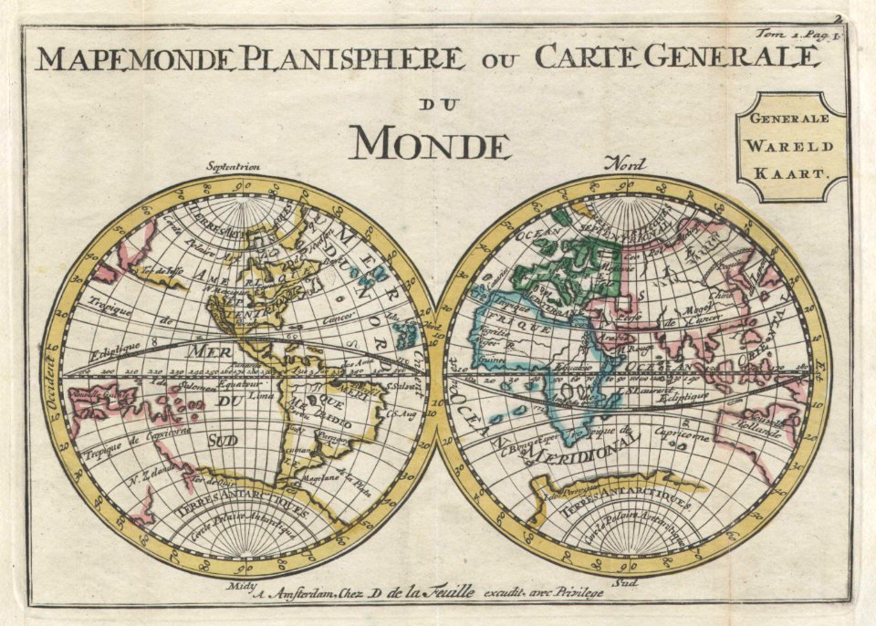
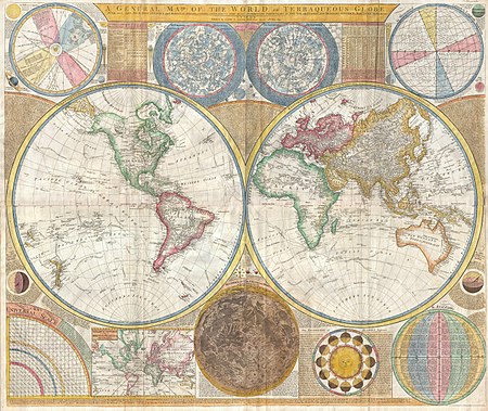
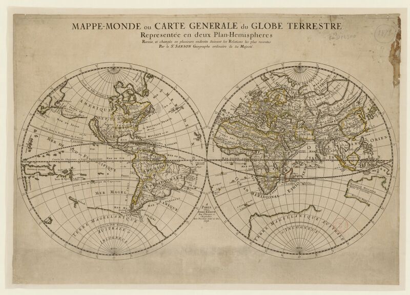
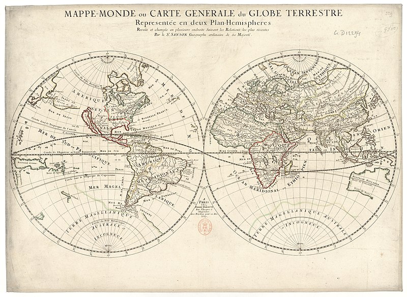
old maps of earth's hemispheres
double hemisphere world maps
self-published work
world war
old constellation maps
maps by samuel dunn
maps by jacques-nicolas bellin
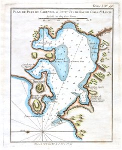
old maps of saint lucia
mappe-monde by guillaume delisle (18th century)
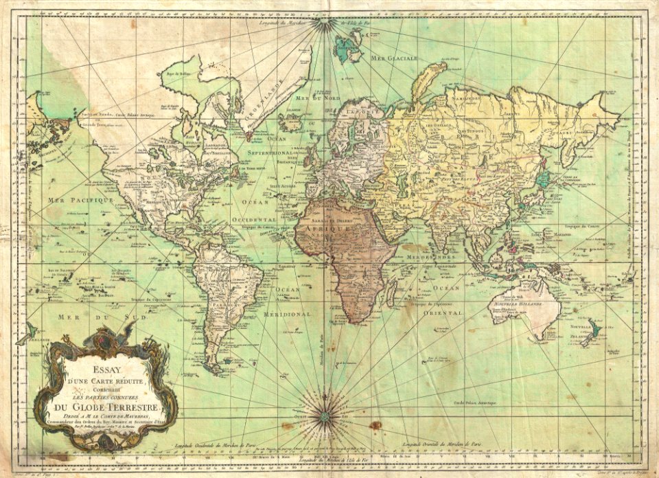
french-language maps of the world
maps of eastern europe
french-language maps
french-language maps of the world
1700s maps of the world
tresor des cartes geographiques (1659)
1650s maps of the world
tresor des cartes geographiques (1659)
old maps of the benelux
reconstructions of old maps
german renaissance
reconstructions of old maps
german renaissance
bibliothèque nationale de france
propaganda map
bibliothèque nationale de france
propaganda map
tresor des cartes geographiques (1659)
1650s maps of india
bibliothèque nationale de france
guillaume sanson
bibliothèque nationale de france
guillaume sanson
19th-century double hemisphere world maps
1800s maps of the world
tresor des cartes geographiques (1659)
17th-century maps of silesia
gaspard de chabrol
maps from gallica
mappe-monde geo-hydrographique (sanson and jaillot, 1674)
bibliothèque nationale de france
tresor des cartes geographiques (1659)
1650s maps of eastern europe
tresor des cartes geographiques (1659)
17th-century maps of siberia
tresor des cartes geographiques (1659)
old maps of tunis
tresor des cartes geographiques (1659)
maps facing east
tresor des cartes geographiques (1659)
1650s maps of the tsardom of russia
1710s maps of eastern europe
1710s maps of the balkans
eran laor cartographic collection
pierre françois tardieu
maps of alsace by guillaume sanson
maps by alexis-hubert jaillot
cartes generales de toutes les parties du monde (1658)
maps by guillaume sanson
cartes generales de toutes les parties du monde (1658)
1658 maps of asia
tresor des cartes geographiques (1659)
1650s maps of denmark
tresor des cartes geographiques (1659)
1650s maps of italy
tresor des cartes geographiques (1659)
1650s maps of china
tresor des cartes geographiques (1659)
1650s maps of ethiopia
tresor des cartes geographiques (1659)
1650s maps of turkey
tresor des cartes geographiques (1659)
1650s maps of hungary
tresor des cartes geographiques (1659)
1650s maps of the americas
tresor des cartes geographiques (1659)
1650s maps of the americas
tresor des cartes geographiques (1659)
1650s maps of portugal
tresor des cartes geographiques (1659)
1650s maps of iran
tresor des cartes geographiques (1659)
1650s maps of france
tresor des cartes geographiques (1659)
1659 maps of europe
tresor des cartes geographiques (1659)
1650s maps of greece
tresor des cartes geographiques (1659)
1650s maps of asia
tresor des cartes geographiques (1659)
1659 maps of africa
atlas minor gerardi mercatoris (1614, maps)
17th-century double hemisphere world maps
antoine-françois tardieu
jean-baptiste poirson
tresor des cartes geographiques (1659)
maps of guinea by mercator-hondius
tresor des cartes geographiques (1659)
17th-century maps of morocco
bibliothèque nationale de france
guillaume sanson
tresor des cartes geographiques (1659)
1650s maps of the iberian peninsula
maps of candia by ortelius and mercator
tresor des cartes geographiques (1659)
17th-century maps of the malay archipelago
tresor des cartes geographiques (1659)
tresor des cartes geographiques (1659)
1650s maps of the ottoman empire
tresor des cartes geographiques (1659)
17th-century maps of the arctic
tresor des cartes geographiques (1659)
1650s maps of the holy roman empire
maps of barbary coast by mercator-hondius
tresor des cartes geographiques (1659)
tresor des cartes geographiques (1659)
maps of cyprus by mercator-hondius
maps of barbary coast by mercator-hondius
tresor des cartes geographiques (1659)
tresor des cartes geographiques (1659)
17th-century maps of the british isles
tresor des cartes geographiques (1659)
17th-century celestial maps
tresor des cartes geographiques (1659)
17th-century maps of scandinavia
tresor des cartes geographiques (1659)
17th-century maps of morocco
tresor des cartes geographiques (1659)
old maps of the whole peloponnese
cartes generales de toutes les parties du monde (1658)
1650s maps of saxony
bibliothèque nationale de france
guillaume sanson
bibliothèque nationale de france
guillaume sanson
bibliothèque nationale de france
guillaume sanson
bibliothèque nationale de france
guillaume sanson
maps of alsace by guillaume sanson
robert cordier (engraver)
bibliothèque nationale de france
1667 sanson map of africa
bibliothèque nationale de france
1667 sanson map of africa
tresor des cartes geographiques (1659)
bibliothèque nationale de france
tresor des cartes geographiques (1659)
bibliothèque nationale de france
mappe-monde geo-hydrographique (sanson and jaillot, 1674)
bibliothèque nationale de france
tresor des cartes geographiques (1659)
bibliothèque nationale de france
tresor des cartes geographiques (1659)
bibliothèque nationale de france
map of italy by guillaume delisle (1700)
1700s maps of italy
18th-century maps of veneto
1700s maps of slovenia
bibliothèque nationale de france
sanson map of lorraine
1727 maps of africa
1720s maps of egypt
bibliothèque nationale de france
cartouches by sanson family
theatre geographique du royaume de france (1632)
mercator 1587 world map
bibliothèque nationale de france
sanson map of lorraine
bibliothèque nationale de france
sanson map of lorraine
mappe-monde geo-hydrographique (sanson and jaillot, 1674)
bibliothèque nationale de france
bibliothèque nationale de france
guillaume sanson
atlas géographique des quatre parties du monde (delisle)
18th-century maps of the iberian peninsula
old maps of former departments of france
maps from gallica
old maps of former departments of france
maps from gallica
eran laor cartographic collection
pierre françois tardieu
1770s maps of the world
1775 maps
antoine-françois tardieu
jean-baptiste poirson
mappe-monde geo-hydrographique (sanson and jaillot, 1674)
bibliothèque nationale de france
atlas géographique des quatre parties du monde (delisle)
18th-century double hemisphere world maps
bibliothèque nationale de france
sanson map of lorraine
gaspard de chabrol
maps from gallica
maps of america by guillaume delisle (18th century)
1760s maps of the americas
maps of italy by sanson and cordier
bibliothèque nationale de france
1 - 100 of 219
Next page
/ 3


![Treasure of geographical maps of the main states of the universe [...], 1659](https://cdn.creazilla.com/illustrations/10001492378/treasure-of-geographical-maps-of-the-main-states-of-the-universe-1659-md.jpg)
![Treasure of geographical maps of the main states of the universe [...], 1659](https://cdn.creazilla.com/illustrations/10000541161/treasure-of-geographical-maps-of-the-main-states-of-the-universe-1659-sm.jpg)
![[Reproduction of the terrestrial globe (orbis imago) by Jean Stabius, 1515] (Facsimile reproduction)](https://cdn.creazilla.com/illustrations/10000781714/reproduction-of-the-terrestrial-globe-orbis-imago-by-jean-stabius-1515-facsimile-reproduction-sm.webp)
![[Reproduction of the terrestrial globe (orbis imago) by Jean Stabius, 1515] (Facsimile reproduction)](https://cdn.creazilla.com/illustrations/10000450806/reproduction-of-the-terrestrial-globe-orbis-imago-by-jean-stabius-1515-facsimile-reproduction-sm.jpg)


![Treasure of geographical maps of the main states of the universe [...], 1659](https://cdn.creazilla.com/illustrations/10000992784/treasure-of-geographical-maps-of-the-main-states-of-the-universe-1659-md.jpg)


![Treasure of geographical maps of the main states of the universe [...], 1659](https://cdn.creazilla.com/illustrations/10000859170/treasure-of-geographical-maps-of-the-main-states-of-the-universe-1659-sm.jpg)


![Treasure of geographical maps of the main states of the universe [...], 1659](https://cdn.creazilla.com/illustrations/10000594631/treasure-of-geographical-maps-of-the-main-states-of-the-universe-1659-md.jpg)
![Treasure of geographical maps of the main states of the universe [...], 1659](https://cdn.creazilla.com/illustrations/10001176343/treasure-of-geographical-maps-of-the-main-states-of-the-universe-1659-md.jpg)
![Treasure of geographical maps of the main states of the universe [...], 1659](https://cdn.creazilla.com/illustrations/10000832962/treasure-of-geographical-maps-of-the-main-states-of-the-universe-1659-md.jpg)
![Treasure of geographical maps of the main states of the universe [...], 1659](https://cdn.creazilla.com/illustrations/10000441201/treasure-of-geographical-maps-of-the-main-states-of-the-universe-1659-md.jpg)
![Treasure of geographical maps of the main states of the universe [...], 1659](https://cdn.creazilla.com/illustrations/10000302483/treasure-of-geographical-maps-of-the-main-states-of-the-universe-1659-md.jpg)


![Treasure of geographical maps of the main states of the universe [...], 1659](https://cdn.creazilla.com/illustrations/10000314824/treasure-of-geographical-maps-of-the-main-states-of-the-universe-1659-md.jpg)
![Treasure of geographical maps of the main states of the universe [...], 1659](https://cdn.creazilla.com/illustrations/10000521357/treasure-of-geographical-maps-of-the-main-states-of-the-universe-1659-md.jpg)
![Treasure of geographical maps of the main states of the universe [...], 1659](https://cdn.creazilla.com/illustrations/10000420918/treasure-of-geographical-maps-of-the-main-states-of-the-universe-1659-md.jpg)
![Treasure of geographical maps of the main states of the universe [...], 1659](https://cdn.creazilla.com/illustrations/10000449944/treasure-of-geographical-maps-of-the-main-states-of-the-universe-1659-md.jpg)
![Treasure of geographical maps of the main states of the universe [...], 1659](https://cdn.creazilla.com/illustrations/10001323164/treasure-of-geographical-maps-of-the-main-states-of-the-universe-1659-md.jpg)
![Treasure of geographical maps of the main states of the universe [...], 1659](https://cdn.creazilla.com/illustrations/10001410826/treasure-of-geographical-maps-of-the-main-states-of-the-universe-1659-md.jpg)
![Treasure of geographical maps of the main states of the universe [...], 1659](https://cdn.creazilla.com/illustrations/10001567991/treasure-of-geographical-maps-of-the-main-states-of-the-universe-1659-md.jpg)
![Treasure of geographical maps of the main states of the universe [...], 1659](https://cdn.creazilla.com/illustrations/10000397491/treasure-of-geographical-maps-of-the-main-states-of-the-universe-1659-md.jpg)
![Treasure of geographical maps of the main states of the universe [...], 1659](https://cdn.creazilla.com/illustrations/10000360844/treasure-of-geographical-maps-of-the-main-states-of-the-universe-1659-md.jpg)
![Treasure of geographical maps of the main states of the universe [...], 1659](https://cdn.creazilla.com/illustrations/10000659025/treasure-of-geographical-maps-of-the-main-states-of-the-universe-1659-md.jpg)
![Treasure of geographical maps of the main states of the universe [...], 1659](https://cdn.creazilla.com/illustrations/10001054877/treasure-of-geographical-maps-of-the-main-states-of-the-universe-1659-md.jpg)
![Treasure of geographical maps of the main states of the universe [...], 1659](https://cdn.creazilla.com/illustrations/10001200125/treasure-of-geographical-maps-of-the-main-states-of-the-universe-1659-md.jpg)
![Treasure of geographical maps of the main states of the universe [...], 1659](https://cdn.creazilla.com/illustrations/10001292785/treasure-of-geographical-maps-of-the-main-states-of-the-universe-1659-md.jpg)
![Treasure of geographical maps of the main states of the universe [...], 1659](https://cdn.creazilla.com/illustrations/10001176342/treasure-of-geographical-maps-of-the-main-states-of-the-universe-1659-md.jpg)
![Treasure of geographical maps of the main states of the universe [...], 1659](https://cdn.creazilla.com/illustrations/10001227179/treasure-of-geographical-maps-of-the-main-states-of-the-universe-1659-md.jpg)


![Treasure of geographical maps of the main states of the universe [...], 1659](https://cdn.creazilla.com/illustrations/10000271069/treasure-of-geographical-maps-of-the-main-states-of-the-universe-1659-md.jpg)
![Treasure of geographical maps of the main states of the universe [...], 1659](https://cdn.creazilla.com/illustrations/10000859165/treasure-of-geographical-maps-of-the-main-states-of-the-universe-1659-md.jpg)

![Treasure of geographical maps of the main states of the universe [...], 1659](https://cdn.creazilla.com/illustrations/10000485227/treasure-of-geographical-maps-of-the-main-states-of-the-universe-1659-md.jpg)
![Treasure of geographical maps of the main states of the universe [...], 1659](https://cdn.creazilla.com/illustrations/10000760159/treasure-of-geographical-maps-of-the-main-states-of-the-universe-1659-md.jpg)
![Treasure of geographical maps of the main states of the universe [...], 1659](https://cdn.creazilla.com/illustrations/10000757788/treasure-of-geographical-maps-of-the-main-states-of-the-universe-1659-md.jpg)
![Treasure of geographical maps of the main states of the universe [...], 1659](https://cdn.creazilla.com/illustrations/10000550553/treasure-of-geographical-maps-of-the-main-states-of-the-universe-1659-md.jpg)
![Treasure of geographical maps of the main states of the universe [...], 1659](https://cdn.creazilla.com/illustrations/10001044907/treasure-of-geographical-maps-of-the-main-states-of-the-universe-1659-md.jpg)
![Treasure of geographical maps of the main states of the universe [...], 1659](https://cdn.creazilla.com/illustrations/10001567990/treasure-of-geographical-maps-of-the-main-states-of-the-universe-1659-md.jpg)
![Treasure of geographical maps of the main states of the universe [...], 1659](https://cdn.creazilla.com/illustrations/10001596623/treasure-of-geographical-maps-of-the-main-states-of-the-universe-1659-md.jpg)
![Treasure of geographical maps of the main states of the universe [...], 1659](https://cdn.creazilla.com/illustrations/10000589616/treasure-of-geographical-maps-of-the-main-states-of-the-universe-1659-md.jpg)
![Treasure of geographical maps of the main states of the universe [...], 1659](https://cdn.creazilla.com/illustrations/10000572901/treasure-of-geographical-maps-of-the-main-states-of-the-universe-1659-md.jpg)
![Treasure of geographical maps of the main states of the universe [...], 1659](https://cdn.creazilla.com/illustrations/10001373480/treasure-of-geographical-maps-of-the-main-states-of-the-universe-1659-md.jpg)
![Treasure of geographical maps of the main states of the universe [...], 1659](https://cdn.creazilla.com/illustrations/10000284064/treasure-of-geographical-maps-of-the-main-states-of-the-universe-1659-md.jpg)
![Treasure of geographical maps of the main states of the universe [...], 1659](https://cdn.creazilla.com/illustrations/10000436833/treasure-of-geographical-maps-of-the-main-states-of-the-universe-1659-md.jpg)
![Treasure of geographical maps of the main states of the universe [...], 1659](https://cdn.creazilla.com/illustrations/10000171002/treasure-of-geographical-maps-of-the-main-states-of-the-universe-1659-md.jpg)
![Treasure of geographical maps of the main states of the universe [...], 1659](https://cdn.creazilla.com/illustrations/10000206928/treasure-of-geographical-maps-of-the-main-states-of-the-universe-1659-md.jpg)


![Treasure of geographical maps of the main states of the universe [...], 1659](https://cdn.creazilla.com/illustrations/10000169261/treasure-of-geographical-maps-of-the-main-states-of-the-universe-1659-md.jpg)
![Treasure of geographical maps of the main states of the universe [...], 1659](https://cdn.creazilla.com/illustrations/10000612015/treasure-of-geographical-maps-of-the-main-states-of-the-universe-1659-md.jpg)

![Treasure of geographical maps of the main states of the universe [...], 1659](https://cdn.creazilla.com/illustrations/10000868471/treasure-of-geographical-maps-of-the-main-states-of-the-universe-1659-lg.jpg)
![Treasure of geographical maps of the main states of the universe [...], 1659](https://cdn.creazilla.com/illustrations/10000714295/treasure-of-geographical-maps-of-the-main-states-of-the-universe-1659-md.jpg)


![Topographical Map of the Department of Montenotte / Written by the care of Mr. Count de Chabrol Prefect. Scale of 10,000 Meters [=Om. 050; 1: 200,000]; Drawn by Cecchi, geographer, between 1806 and 1812](https://cdn.creazilla.com/illustrations/10000562582/topographical-map-of-the-department-of-montenotte-written-by-the-care-of-mr-count-de-chabrol-prefect-scale-of-10000-meters-om-050-1-200000-drawn-by-cecchi-geographer-between-1806-and-1812-sm.webp)
![Topographical Map of the Department of Montenotte / Written by the care of Mr. Count de Chabrol Prefect. Scale of 10,000 Meters [=Om. 050; 1: 200,000]; Drawn by Cecchi, geographer, between 1806 and 1812](https://cdn.creazilla.com/illustrations/10000886036/topographical-map-of-the-department-of-montenotte-written-by-the-care-of-mr-count-de-chabrol-prefect-scale-of-10-000-meters-om-050-1-200-000-drawn-by-cecchi-geographer-between-1806-and-1812-sm.jpg)


![Map of St Domingue by JB Poirson, 1803, revised and expanded in 1817. 10 Myriameters [=Om. 0625; 1: 1, 600, 000]. Engraved by Tardieu senior](https://cdn.creazilla.com/illustrations/10001427384/map-of-st-domingue-by-jb-poirson-1803-revised-and-expanded-in-1817-10-myriameters-om-0625-1-1-600-000-engraved-by-tardieu-senior-md.jpg)


