Log in
All resources
Create a design
62 Free Images of 17th Century Maps Of Europe
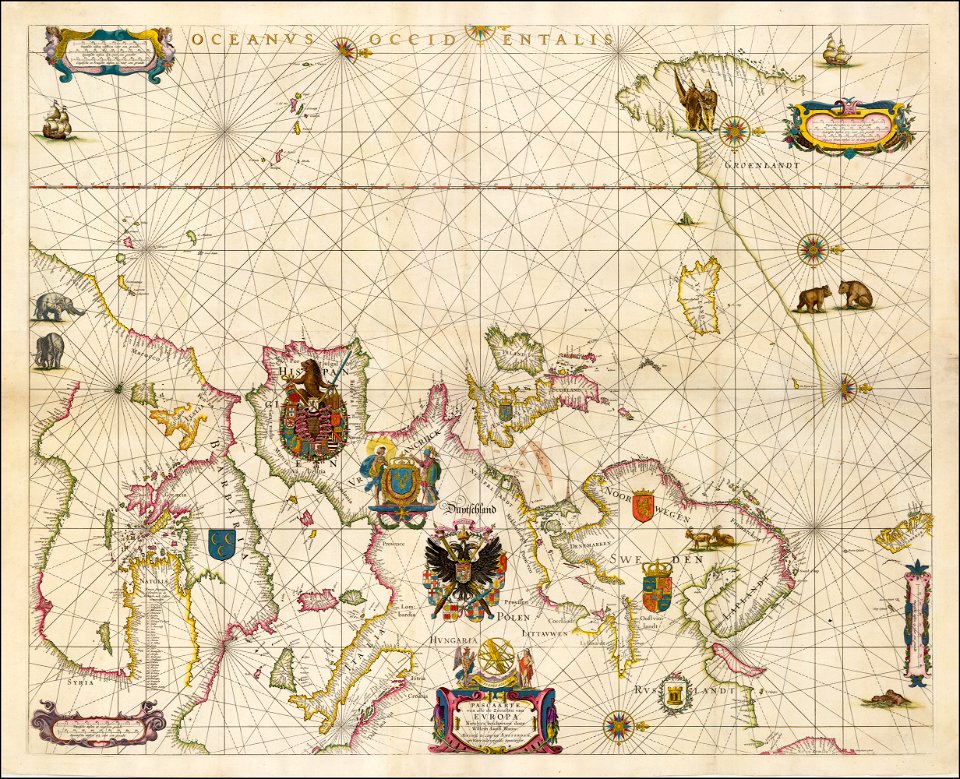
joan blaeu
copper engraving print
british library
description de l'universe
alain manesson mallet
17th-century maps of the mediterranean sea
atlas maior, vol 2 (sweden, russia, poland, eastern europe, and greece) - joan blaeu, 1667 - bl 114.h(star).2
maps by willem and johannes blaeu
1685 maps of europe
ships on maps
the voyage of the vega round asia and europe
third voyage of willem barentsz
17th-century maps of the black sea
maps by willem and johannes blaeu
17th-century maps of the black sea
maps by willem and johannes blaeu
17th-century maps of the black sea
maps by willem and johannes blaeu
maps by willem and johannes blaeu
17th-century maps of europe
17th-century maps of the mediterranean sea
guillaume sanson
17th-century maps of schleswig-holstein
maps of kreis nordfriesland
17th-century maps of europe
maps by carolus allard
portolan charts made in the 17th century
maps by willem and johannes blaeu
portolan charts made in the 17th century
maps by willem and johannes blaeu
atlas maior, vol 2 (sweden, russia, poland, eastern europe, and greece) - joan blaeu, 1667 - bl 114.h(star).2
17th-century maps of estonia
atlas maior, vol 1 (northern europe, norway, and denmark) - joan blaeu, 1667 - bl 114.h(star).1
1667 maps
historical coats of arms of denmark
ships on maps
orbispictus - extracted images
17th-century maps of europe
turgot map of paris, norman b. leventhal map center
sheet 19 of the turgot map of paris
1700s maps of the ottoman empire
maps made in the 17th century
atlas maior, vol 1 (northern europe, norway, and denmark) - joan blaeu, 1667 - bl 114.h(star).1
17th-century double hemisphere world maps
17th-century maps of the mediterranean sea
description de l'universe
maps by willem and johannes blaeu
1659 maps
map of europe by nicolas and guillaume sanson (1669)
bibliothèque nationale de france
17th-century maps of the mediterranean sea
golfe de saint-tropez
atlas maior, vol 2 (sweden, russia, poland, eastern europe, and greece) - joan blaeu, 1667 - bl 114.h(star).2
17th-century maps of scandinavia
17th-century maps of europe
latin-language maps
description de l'universe
1685 maps of europe
1600s maps of the netherlands
1609 maps of europe
atlas maior, vol 2 (sweden, russia, poland, eastern europe, and greece) - joan blaeu, 1667 - bl 114.h(star).2
17th-century maps of finland
daniel de la feuille
1708 maps
portolan charts by willem and johannes blaeu
17th-century maps of europe
maps by jodocus hondius
1610 maps of europe
17th-century maps of greenland
description de l'universe
atlas maior, vol 2 (sweden, russia, poland, eastern europe, and greece) - joan blaeu, 1667 - bl 114.h(star).2
17th-century maps of scandinavia
17th-century maps of scandinavia
description de l'universe
17th-century maps of the mediterranean sea
1610 maps of europe
description de l'universe
1680s maps of england
description de l'universe
1680s maps of england
maps of novaya zemlya
1590s maps
atlas maior, vol 1 (northern europe, norway, and denmark) - joan blaeu, 1667 - bl 114.h(star).1
17th-century maps of iceland
atlas maior, vol 2 (sweden, russia, poland, eastern europe, and greece) - joan blaeu, 1667 - bl 114.h(star).2
17th-century maps of prussia
description de l'universe
1680s maps of england
atlas maior, vol 2 (sweden, russia, poland, eastern europe, and greece) - joan blaeu, 1667 - bl 114.h(star).2
17th-century maps of hungary
atlas maior, vol 2 (sweden, russia, poland, eastern europe, and greece) - joan blaeu, 1667 - bl 114.h(star).2
17th-century maps of greece
17th-century maps of france
description de l'universe
17th-century maps of france
description de l'universe
17th-century maps of france
description de l'universe
17th-century maps of italy
description de l'universe
18th-century maps of greenland
old maps of the arctic
atlas maior, vol 2 (sweden, russia, poland, eastern europe, and greece) - joan blaeu, 1667 - bl 114.h(star).2
17th-century maps of romania
1740s maps of the caribbean
daniel de la feuille
atlas maior, vol 2 (sweden, russia, poland, eastern europe, and greece) - joan blaeu, 1667 - bl 114.h(star).2
17th-century maps of the aegean sea
atlas maior, vol 2 (sweden, russia, poland, eastern europe, and greece) - joan blaeu, 1667 - bl 114.h(star).2
17th-century maps of poland
maps by willem and johannes blaeu
1630s maps of the caucasus
atlas maior, vol 2 (sweden, russia, poland, eastern europe, and greece) - joan blaeu, 1667 - bl 114.h(star).2
17th-century maps of the aegean sea
17th-century maps of italy
description de l'universe
17th-century maps of italy
description de l'universe
maps by willem and johannes blaeu
17th-century maps of europe
17th-century maps of europe
description de l'universe
descriptio daciarum (17th-century map)
maps by pieter van der keere
1650s maps of the americas
1658 maps
maps in the rijksmuseum amsterdam
old maps of the ottoman empire
1740s maps of the world
maps by emanuel bowen
maps by pieter mortier
le neptune francois
maps in the rijksmuseum amsterdam
works after adriaen van de velde
1 - 62 of 62
/ 1