Log in
All resources
Create a design
26,489 Free Artworks of Map
bibliothèque nationale de france
eran laor cartographic collection
latin-language maps
paper
british museum
theatri praecipvarvm totivs mvndi vrbivm : liber sextvs (1618)
national library of poland
english-language maps
willem blaeu
maps in the library of congress
a map of the valdichiana (rcin 912278)
high renaissance,renaissance
1750s portrait paintings from ireland
thomas hickey
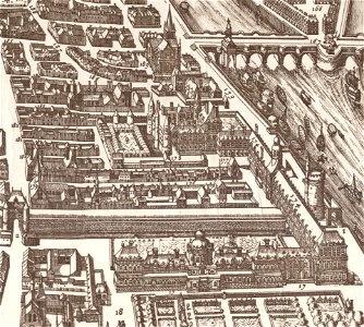
palais du louvre in the 1610s
palais du louvre on old maps
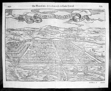
cosmographia (1588) by sebastian münster
maps of cusco by braun & hogenberg
maps from the earth and its inhabitants, vol. xi
africa in the 1890s
gemeente atlas van nederland - south holland
old maps of gouda
18th-century maps of the dardanelles
1700s maps of turkey
maps in the library of congress
fidelity building (knoxville)
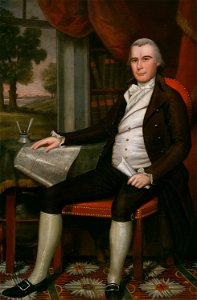
portrait paintings in the art institute of chicago
paintings by ralph earl
maps of abyssinia by mercator-hondius
historisk atlas (stockholm, norstedt & söner, 1880)
maps of 11th-century italy
curt teich postcard archives
map postcards
maps from the earth and its inhabitants, vol. x
19th-century maps of africa
matthäus merian der jüngere
great comet of 1680
maps from the mechanical curator collection
maps of regent's park
gemeente atlas van nederland - drenthe
maps of de wolden
maps of fortress of charlemont by braun & hogenberg
maps of givet and charlemont city walls
ceiling of the terrace of the geographical maps (uffizi gallery, florence)
ceiling of the terrace of the geographical maps (uffizi gallery, florence)
viktoriastraße (berlin-lichterfelde)
parts of old maps of berlin
prints by ambrogio brambilla
old maps of parma
ceiling of the terrace of the geographical maps (uffizi gallery, florence)
beschryving van 'sgraven-hage
the hague in the 1570s
military equipment of muscovite russia
details of sigismund's map of moscow
grenzkarte der preussischen, russischen und oestreichischen monarchien (1796)
maps of pomerania province
maps by pieter van der keere
old maps of friesland
theatri praecipvarvm totivs mvndi vrbivm : liber sextvs (1618)
maps of poznań by braun & hogenberg
mountains and lakes in cumberland and westmoreland (1808)
maps in the british museum
atlas vingboons
1665
maps in the library of congress
1790 maps
maps of ancient italy by philipp clüver
maps of samnium
theatri praecipvarvm totivs mvndi vrbivm : liber sextvs (1618)
maps of biecz by braun & hogenberg
mountains and lakes in cumberland and westmoreland (1808)
maps in the british museum
john rocque 1746 crops from library of congress
john rocque's maps of london
maps from gallica
old maps of rome
maps of the peloponnese by gerardus mercator
1640s maps of greece
old maps of bourbonnais
1660s maps of france
17th-century maps of savoie
old maps of savoie
17th-century maps of the netherlands
maps by pieter van der keere
old maps of antikythera
old maps of kythira
old maps of the shetland islands
old maps of the orkney islands
maps by hendrik hondius the younger
1632 maps of africa
theatri praecipvarvm totivs mvndi vrbivm : liber sextvs (1618)
maps of čáslav by braun & hogenberg
theatri praecipvarvm totivs mvndi vrbivm : liber sextvs (1618)
maps of eisenstadt by braun & hogenberg
maps by thomas starling
1842 maps
maps of blois by braun & hogenberg
urbanisation in loir-et-cher
maps of the islands of greece by marco boschini (1658)
old maps of lesbos
theatri praecipvarvm totivs mvndi vrbivm : liber sextvs (1618)
maps of dillenburg by braun & hogenberg
the new forest, its history and its scenery
symbolism
a.de la motraye's travels through europe, asia, and into part of africa (1723) by la mottraye
realism
the generall historie of virginia (john smith)
17th-century maps of virginia
gemeente atlas van nederland - groningen
maps of hoogezand
merian sueviae
baroque
eran laor cartographic collection
pierre françois tardieu
dominikanerkloster (frankfurt)
judengasse (frankfurt)
claes jansz. visscher (ii)
atlas van stolk
maps in the library of congress
emory place historic district
castles in landkreis biberach
uttenweiler
old maps of farmakonisi
old maps of agathonisi
maps by guillaume sanson
old maps of friesland
the british monarchy (1743)
maps in the british museum
maps by jean-baptiste bourguignon d'anville
1727 maps of africa
sanson maps of the netherlands
1680s maps of the netherlands
map of the upper rhenian circle by sanson
1670s maps of hesse
map of the upper rhenian circle by sanson
1700s maps of north rhine-westphalia
maps of the islands of greece by marco boschini (1658)
old maps of the peloponnese
maps of los palacios by braun & hogenberg
maps of las cabezas by braun & hogenberg
17th-century maps of the strait of magellan
1668 maps of south america
1780s maps of tunisia
1780s maps of libya
1698 map of evesché de meaux
robert cordier (engraver)
gemeente atlas van nederland - north holland
egmond-binnen
media contributed by university of illinois urbana-champaign university library
1631 maps of africa
geographia universalis (1545) in the british museum
german renaissance,northern renaissance
maps in the library of congress
1763 maps of north america
geographia universalis (1545) in the british museum
german renaissance,northern renaissance
geographia universalis (1545) in the british museum
german renaissance,northern renaissance
eran laor cartographic collection
william hughes (geographer)
17th-century engravings
johannes de ram
eran laor cartographic collection
willem blaeu
eran laor cartographic collection
pieter van der keere
eran laor cartographic collection
willem blaeu
eran laor cartographic collection
willem blaeu
eran laor cartographic collection
nicolaus van aelst
eran laor cartographic collection
william dickes
eran laor cartographic collection
pieter van der keere
eran laor cartographic collection
willem blaeu
illustrations from the mysterious island by jules férat
maps of the mysterious island
eran laor cartographic collection
theodor de bry
eran laor cartographic collection
romanticism
eran laor cartographic collection
alain manesson-mallet
eran laor cartographic collection
william hughes (geographer)
eran laor cartographic collection
willem blaeu
eran laor cartographic collection
romanticism
maps of barbary coast by mercator-hondius
maps by jan janssonius
maps of ancona by braun & hogenberg
maps in the british museum
paintings by antônio parreiras in the museu antônio parreiras
landscape paintings by antônio parreiras
eran laor cartographic collection
bernardino amico
print room of the university of antwerp
kaarten van vlaanderen (prentenkabinet)
eran laor cartographic collection
willem albert bachiene
eran laor cartographic collection
giovanni maria cassini
9701 - 9800 of 26,489
Next page
/ 265