Log in
All resources
Create a design
26,489 Free Artworks of Map
copper engraving print
british library
joan blaeu
bibliothèque nationale de france
a school geography (1898) by bird
atlas maior, vol 3 (germany) - joan blaeu, 1667 - bl 114.h(star).3
baroque
gemeente atlas van nederland - north brabant
atlas maior, vol 2 (sweden, russia, poland, eastern europe, and greece) - joan blaeu, 1667 - bl 114.h(star).2
new york state supreme court 60 centre street
atlas maior, vol 3 (germany) - joan blaeu, 1667 - bl 114.h(star).3
copper engraving print
atlas maior, vol 3 (germany) - joan blaeu, 1667 - bl 114.h(star).3
copper engraving print
atlas maior, vol 3 (germany) - joan blaeu, 1667 - bl 114.h(star).3
copper engraving print
atlas maior, vol 2 (sweden, russia, poland, eastern europe, and greece) - joan blaeu, 1667 - bl 114.h(star).2
copper engraving print
carte des pays-bas catholiques by guillaume sanson
cartouches by sanson family
atlas maior, vol 1 (northern europe, norway, and denmark) - joan blaeu, 1667 - bl 114.h(star).1
copper engraving print
atlas maior, vol 3 (germany) - joan blaeu, 1667 - bl 114.h(star).3
copper engraving print
atlas maior, vol 2 (sweden, russia, poland, eastern europe, and greece) - joan blaeu, 1667 - bl 114.h(star).2
copper engraving print
atlas maior, vol 3 (germany) - joan blaeu, 1667 - bl 114.h(star).3
copper engraving print
atlas maior, vol 3 (germany) - joan blaeu, 1667 - bl 114.h(star).3
copper engraving print
atlas maior, vol 3 (germany) - joan blaeu, 1667 - bl 114.h(star).3
copper engraving print
scientific journals of the united states, 1902
old maps of lorain county, ohio
atlas maior, vol 2 (sweden, russia, poland, eastern europe, and greece) - joan blaeu, 1667 - bl 114.h(star).2
copper engraving print
map of prague by joseph daniel huber
romantic music
atlas maior, vol 3 (germany) - joan blaeu, 1667 - bl 114.h(star).3
copper engraving print
atlas maior, vol 2 (sweden, russia, poland, eastern europe, and greece) - joan blaeu, 1667 - bl 114.h(star).2
copper engraving print
atlas maior, vol 2 (sweden, russia, poland, eastern europe, and greece) - joan blaeu, 1667 - bl 114.h(star).2
copper engraving print
old maps of south holland
piet schipperus
a school geography (1898) by bird
old maps of athens
a school geography (1898) by bird
1898 maps of india
old maps of heusden, north brabant
piet schipperus
a school geography (1898) by bird
maps of the panama canal
ghosts & ghoulish scenes
a school geography (1898) by bird
old maps of oresund
maps by christian sgrothen
garzweiler
a school geography (1898) by bird
maps of tokelau
a school geography (1898) by bird
old maps of sydney
a school geography (1898) by bird
1890s maps of istanbul
a school geography (1898) by bird
maps of the nicaragua canal
a school geography (1898) by bird
old maps of melbourne
a school geography (1898) by bird
old maps of auckland
cartouches by alexis-hubert jaillot
17th-century maps of asia
new york state supreme court 60 centre street
bromley maps of manhattan published 1921–23
new york state supreme court 60 centre street
bromley maps of manhattan published in 1925
new york state supreme court 60 centre street
bromley maps of manhattan published in 1927
lettres sur la morée (1808)
old maps of kythira
maps of the history of bosnia and herzegovina in modern times
1890s maps of the balkans
the great south - a record of journeys (1875)
1875 maps of the united states
19th-century maps of istria
1890s maps of croatia
manual of british topography, a catalogue of county and local histories, pamphlets, views, drawings, maps, etc. connected with and illustrating the principal localities in the united kingdom (1909)
william daniell
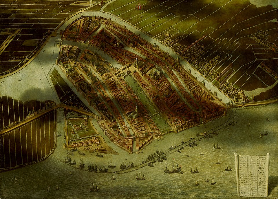
topographical paintings in the amsterdam museum
paintings of amsterdam
advertising posters for the chemins de fer de paris à lyon et à la méditerranée
hugo d’alesi
german renaissance,northern renaissance
portrait paintings of men on stamps
the magazine of american history with notes and queries (1877)
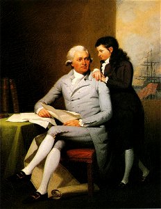
john andré
eran laor cartographic collection
cornelis de bruyn
nypl the miriam and ira d. wallach division of art, prints and photographs: print collection
impressionism
library of the university of vienna
map of vienna by jacob hoefnagel
arnoldus montanus
maps of dejima
battle of levice
baroque
gemeente atlas van nederland - north brabant
maps of deurne, netherlands
topographia braunschweig lüneburg (merian)
baroque
maps by willem and johannes blaeu
1662
baumwollspinnerei im sood
fabrikkanal sihltal
engravings of topographia braunschweig lüneburg
baroque
maps of arnsberg by braun & hogenberg
history of arnsberg
hortus sanitatis, 1497
hieronymus brunschwig
gemeente atlas van nederland - north brabant
maps of werkendam
paintings of the edo period
yosa buson
friedrich bernhard werner
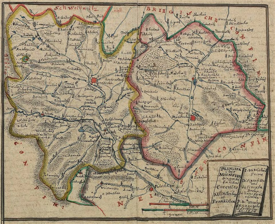
duchy of ziębice
crowned lions rampant with swords
arrows in heraldry
maps by isaak tirion
1740s maps of japan
collections of the museum of the american revolution
david martin (artist)
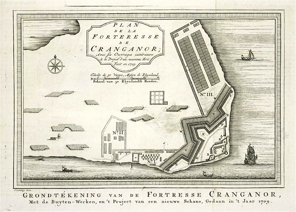
maps of the dutch east india company - india
cranganore fort
map of vienna by jacob hoefnagel
drawings of churches
old maps of freiburg im breisgau
baroque
topographischer atlas der schweiz
palügletscher
map of vienna by jacob hoefnagel
stubenbrücke
maps from gallica
guides joanne
geografia tavole moderne di geografia de la maggior parte del mondo di diversi avtori raccolte et messe secondo l'ordine di tolomeo con i disegni di molte città et fortezze di diverse provintie
maps in the library of congress
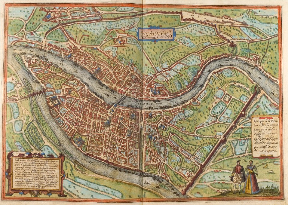
maps of lyon by braun & hogenberg
historical images of lyon
chicago and the midwest, newberry library
rand mcnally
palatinatus rheni (merian)
baroque
svg cross sections of human molar teeth
svg gray's anatomy plates
nicolaas samuel crucquius
old maps of delfland
gemeente atlas van nederland - zeeland
old maps of vlissingen
gemeente atlas van nederland - north brabant
lithoijen
old maps of athens
1896 in athens
history of groningen (province)
maps of the dollard
gemeente atlas van nederland - zeeland
old maps of tholen
gemeente atlas van nederland - north brabant
liempde
gemeente atlas van nederland - north brabant
schaijk
gemeente atlas van nederland - north brabant
diessen
19th-century satirical maps
achille belloguet
gemeente atlas van nederland - north brabant
geffen
palatinatus rheni (merian)
baroque
engravings by matthäus merian
baroque
portrait paintings by john trumbull
romanticism
pierre antoine tardieu
françois houiste
construction drawings in the stadsarchief amsterdam
daniel stoopendaal
construction drawings in the stadsarchief amsterdam
daniel stoopendaal
old maps of brabant
1666 in belgium
maps of antwerp by braun & hogenberg
bibliothèque nationale de france
maps of the islands of greece by marco boschini (1658)
old maps of sifnos
maps of provence by pierre-jean de bompar
maps by hendrik hondius the younger
maps of ancona by braun & hogenberg
bibliothèque nationale de france
maps of the islands of greece by marco boschini (1658)
old maps of skyros
maps of moers by johannes mercator
bibliothèque nationale de france
maps of avignon by braun & hogenberg
bibliothèque nationale de france
old maps of middelburg, zeeland
maps by nicolaes visscher i
maps of enkhuizen by braun & hogenberg
bibliothèque nationale de france
14901 - 15000 of 26,489
Next page
/ 265