Floor plan of the fort at Cranganor, Jakob van der Schley, 1755

Floor plan of the fort at Cranganor, Jakob van der Schley, 1755

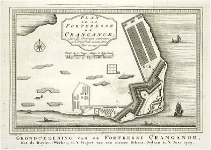
Floor plan of the fort at cranganor. Plan de la forteresse de cranganor / avec ses ouvrages extérieurs. Grondtékening van de fortresse cranganor, / met de buyten-werken, en 't project van een nieuwe schans, gedaan in 't jaar 1709. The situation is dated 1709, but the floor plan is included in du bois' 'histoire générale des voyages' from 1752. The illustration largely corresponds to that in valentyn, 'oud en nieuw-oostindiën', part vb, ii, after p. 10. Cf. Koninklijke bibliotheek, the hague, inv. Nr. 185 a 5, part vb, ii, after p. 10 and scheepvaartmuseum, amsterdam, inv. Nr. Snsm_b0032(109)06[chart041]. Date: 1755. Dimensions: height: 21 cm (8.2 in); width: 15 cm (5.9 in). Medium: engraving on paper. Collection: Koninklijke Bibliotheek. AMH-8021-KB Floor plan of the fort at Cranganor
Edit image
Published by:
Creazilla
Author: Jakob van der SchleySource: commons.wikimedia.org

Loading...

0 downloads
Loading...
maps of the dutch east india company - indiacranganore fort1755 mapsmaps by jakob van der schleyengraving on paperkoninklijke bibliotheekjakob van der schley

MORE LIKE THIS

Creazilla logo
Over 10 million free graphic resources for content creators and designers.
© 2018 - 2025 Creazilla
Our resourcesAll imagesPhotosDigital illustrationsClipartIconsPNG ImagesEmojisSilhouettesTraditional Art3D ModelsVectorsFontsColor namesColor palettesGradientsAudioAnimationVideosTemplates
InformationAbout CreazillaTerms of useTech teamPrivacy policyLicence Information
FeedbackContact Us