Log in
All resources
Create a design
127 Free Artworks of 18th Century Maps Of Cities
bibliothèque nationale de france
maps of paris from bibliothèque nationale de france
turgot map of paris, bibliothèque nationale de france
atlas map
maps made in the 18th century
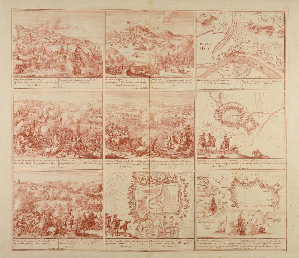
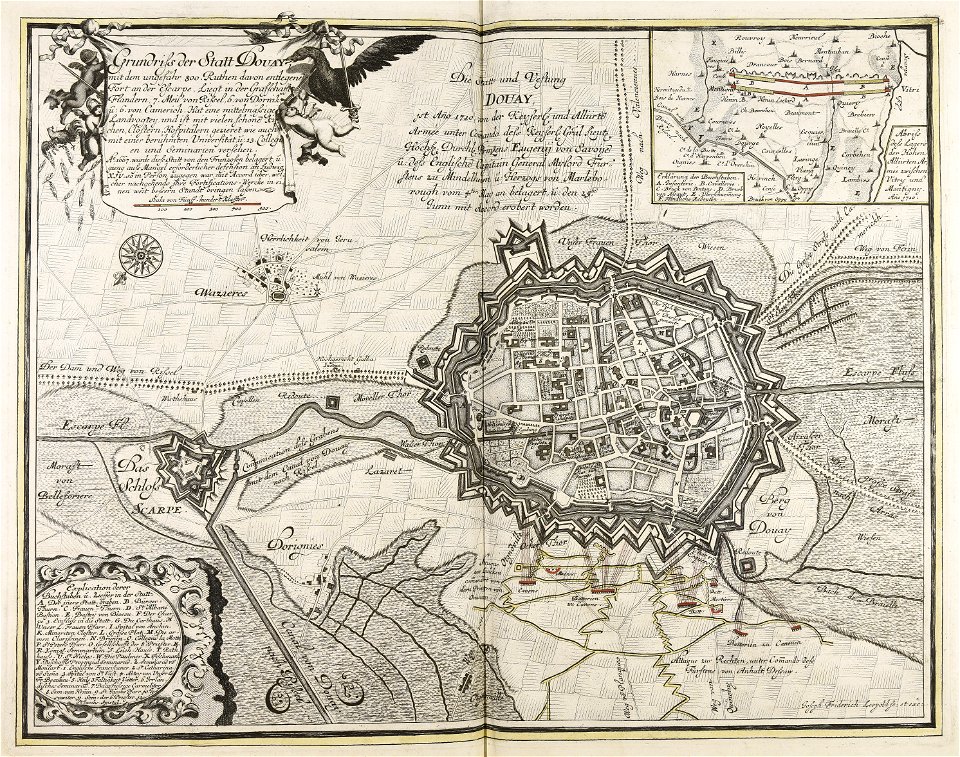
war of the spanish succession
18th-century engravings
old maps of europe
atlantis magni tomus primus (biblioteca comunale di trento)
pieter schenk (i)
collections de la bibliothèque nationale et universitaire de strasbourg
maps by matthäus seutter
collections de la bibliothèque nationale et universitaire de strasbourg
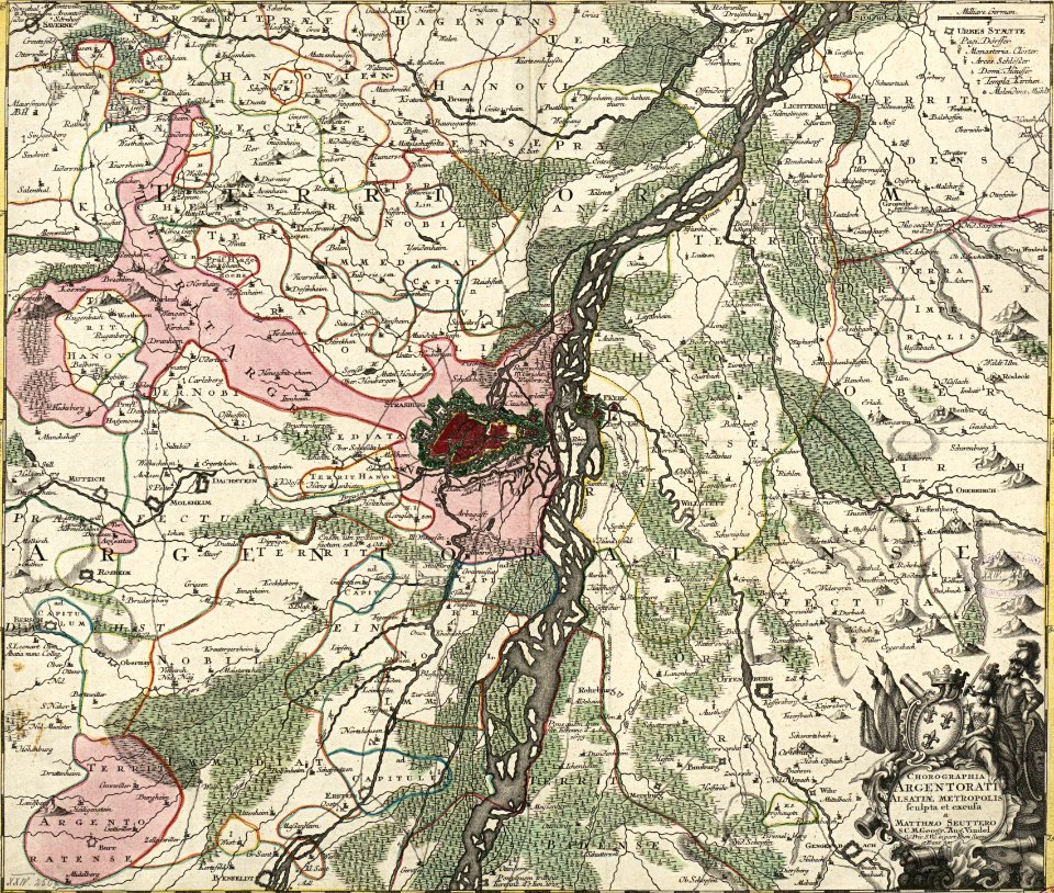
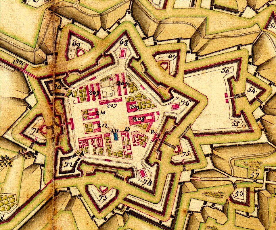
maps of strasbourg in the 18th century
prints from the peace palace library
utrecht in the 18th century
historical images of melaka city
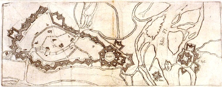
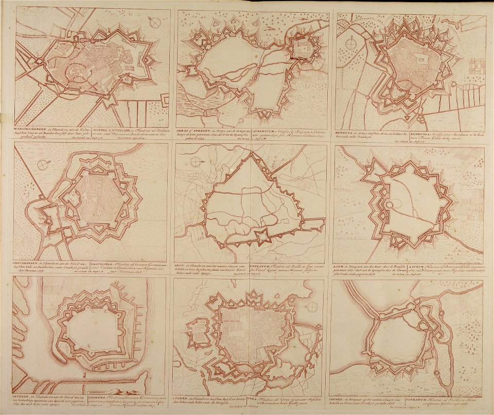
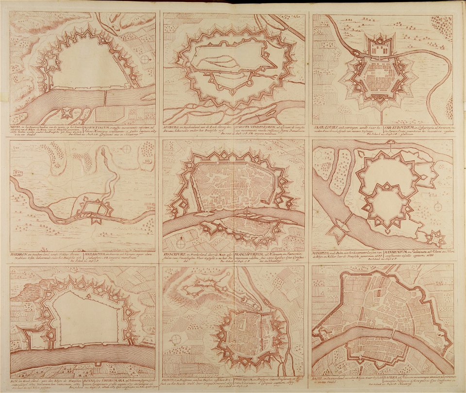
18th-century fortress plans
history of rhine river in germany
vauban
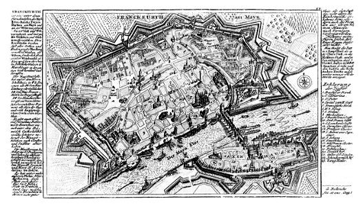
city walls of frankfurt am main
gabriel bodenehr
maps made in the 18th century
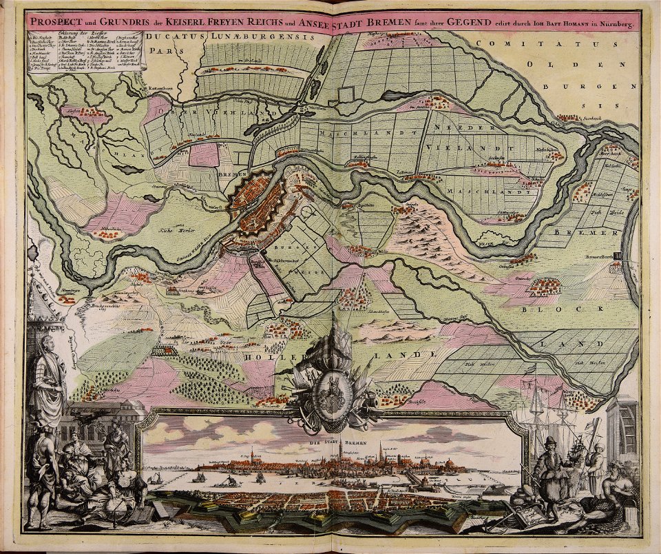
johann baptist homann
new market square in rzeszów
maps of 18th-century europe
maps made in the 18th century
18th-century engravings
maps made in the 18th century
18th-century engravings
maps made in the 18th century
18th-century engravings
maps made in the 18th century
18th-century engravings
maps made in the 18th century
18th-century engravings
maps made in the 18th century
18th-century engravings
maps made in the 18th century
18th-century engravings
maps made in the 18th century
18th-century engravings
maps made in the 18th century
18th-century engravings
greece
italy
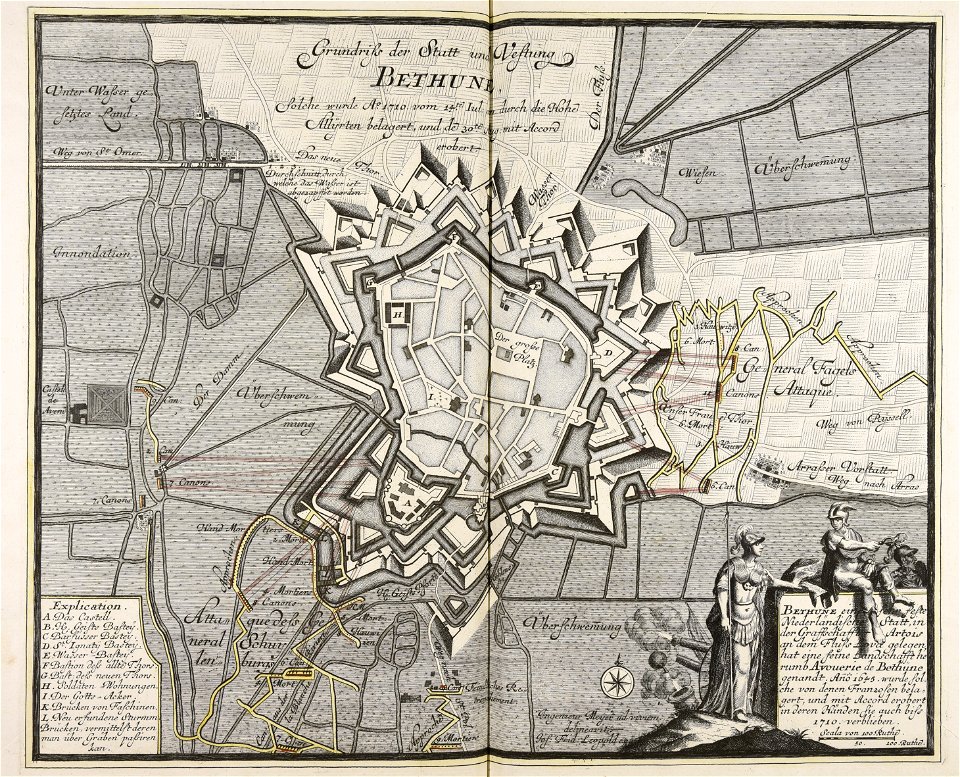
old maps of béthune
1710
war of the spanish succession
1710
old constellation maps
maps by samuel dunn
extracts from carta hydrographica y chorographica de las yslas filipinas
baroque painting
old maps of seville
1788 maps
turgot map of paris, norman b. leventhal map center
sheet 19 of the turgot map of paris
old maps of edinburgh
maps by john rocque
bern city map of 1638 by matthäus merian
baroque
18th-century maps of antwerp
maps of antwerp city walls
collections of the kobe city museum
18th-century maps of africa
old maps of seville
1788 maps of spain
athens in the ottoman era
old maps of athens
maps of san juan, puerto rico
san juan bay, puerto rico
carta hydrographica y chorographica de las yslas filipinas
baroque painting
atlas van der hagen (volume 3)
atlas van der hagen
maps by john cary
1799 maps
1860s maps of new york (state)
maps showing 1776
18th-century maps of antwerp
maps of antwerp city walls
18th-century maps of antwerp
maps of antwerp city walls
18th-century maps of the strait of magellan
1700s maps of argentina
18th-century maps of antwerp
anna beeck
maps by john cary
1801 maps
maps of utrecht (city) city walls
old maps of utrecht (city)
maps by tomas lopez
1785 maps
turgot map of paris, bibliothèque nationale de france
maps of paris from bibliothèque nationale de france
turgot map of paris, bibliothèque nationale de france
maps of paris from bibliothèque nationale de france
turgot map of paris, bibliothèque nationale de france
maps of paris from bibliothèque nationale de france
turgot map of paris, bibliothèque nationale de france
maps of paris from bibliothèque nationale de france
turgot map of paris, bibliothèque nationale de france
maps of paris from bibliothèque nationale de france
turgot map of paris, bibliothèque nationale de france
maps of paris from bibliothèque nationale de france
turgot map of paris, bibliothèque nationale de france
maps of paris from bibliothèque nationale de france
turgot map of paris, bibliothèque nationale de france
maps of paris from bibliothèque nationale de france
maps of san juan, puerto rico
san juan bay, puerto rico
turgot map of paris, bibliothèque nationale de france
maps of paris from bibliothèque nationale de france
turgot map of paris, bibliothèque nationale de france
maps of paris from bibliothèque nationale de france
turgot map of paris, bibliothèque nationale de france
maps of paris from bibliothèque nationale de france
turgot map of paris, bibliothèque nationale de france
maps of paris from bibliothèque nationale de france
turgot map of paris, bibliothèque nationale de france
maps of paris from bibliothèque nationale de france
turgot map of paris, bibliothèque nationale de france
maps of paris from bibliothèque nationale de france
turgot map of paris, bibliothèque nationale de france
maps of paris from bibliothèque nationale de france
turgot map of paris, bibliothèque nationale de france
maps of paris from bibliothèque nationale de france
turgot map of paris, bibliothèque nationale de france
maps of paris from bibliothèque nationale de france
turgot map of paris, bibliothèque nationale de france
maps of paris from bibliothèque nationale de france
turgot map of paris, bibliothèque nationale de france
maps of paris from bibliothèque nationale de france
turgot map of paris, bibliothèque nationale de france
maps of paris from bibliothèque nationale de france
maps by pieter mortier
maps from gallica
maps of paris from bibliothèque nationale de france
proletarian literature
maps of brest from bibliothèque nationale de france
lithographs of brest, france
print room of the university of antwerp
18th-century maps of antwerp
18th-century maps of puerto rico
1785 maps
east prospect of the city of philadelphia
independence hall in art
ramparts of châlons
city gates in marne
maps by pieter mortier
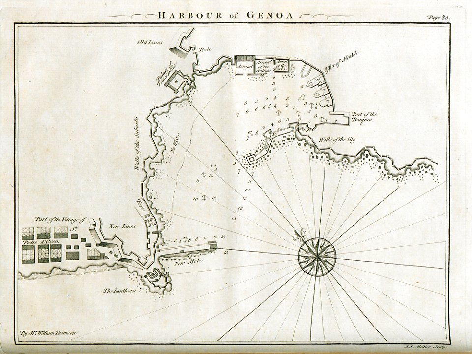
old maps of genoa
18th-century maps of istanbul
1771 maps of turkey
thomas milton
1739 maps
maps of paris in the 1790s
1797 maps
maps from university of amsterdam special collections
atlas der neederlanden
maps by nicolaes visscher i
old maps of assyria
maps from gallica
pierre mortier
old maps of milan
antoine aveline
maps of paris from the david rumsey historical map collection
map of paris by jouvin de rochefort (boutier 133)
old maps of vermandois
maps of somme river
maps of cities in venezuela
maps by juan lopez
lawrence h. slaughter collection of english maps, charts, globes, books and atlases
pre-raphaelite brotherhood
18th-century maps of gibraltar
maps by tomas lopez
18th-century maps of new orleans
maps in the library of congress
18th-century maps of catalonia
daniel de la feuille
18th-century maps of ireland
old maps of dublin
maps of america by guillaume delisle (18th century)
1760s maps of the americas
prints in the national gallery of art (washington, d.c.)
francesco zucchi
maps from university of amsterdam special collections
caartboeck van voorne, 1701
18th-century maps of strasbourg
1740s maps of france
maps by jakob van der schley
history of hormuz island
lawrence h. slaughter collection of english maps, charts, globes, books and atlases
nypl lionel pincus and princess firyal map division
prints of cartouches in the rijksmuseum amsterdam
maps in the rijksmuseum amsterdam
maps of spain by tomas lopez
18th-century maps of madrid
maps of 's-hertogenbosch by braun & hogenberg
atlas beudeker
old maps of nagasaki
guillaume dheulland
maps made in the 18th century
johann david schleuen
daniel de la feuille
1708 maps
1739 maps of france
plan de turgot
1739 maps of france
louis bretez
1 - 100 of 127
Next page
/ 2


![Stadsprofiel van] VENETIA, Joan Blaeu, 1704](https://cdn.creazilla.com/illustrations/10000311106/stadsprofiel-van-venetia-joan-blaeu-1704-md.jpeg)


![Map of Paraguay, Chile, and Strait of Magellan - Guillaume de L'Isle, [1703-1708]](https://cdn.creazilla.com/illustrations/10001534848/map-of-paraguay-chile-and-strait-of-magellan-guillaume-de-lisle-1703-1708-md.jpg)


![Map and images of the city and free glory of Heenvliet / I. Luiken fecit cum aqua forti; I. Stemmer's sculpsit; A. Steyaart invenit, Romeyn de Hooghe, [1701]](https://cdn.creazilla.com/illustrations/10001201061/map-and-images-of-the-city-and-free-glory-of-heenvliet-i-luiken-fecit-cum-aqua-forti-i-stemmers-sculpsit-a-steyaart-invenit-romeyn-de-hooghe-1701-md.jpg)


![The Course of the Somme in the vicinity of which course are situated, the Ponthieu, the Amienois, the Santerre and the Vermandois / By N. de Fer... Scale of Three Hours of Travel [=1: 139 200 ]; H. Van Loon sculp, Herman van Loon, 1709](https://cdn.creazilla.com/illustrations/10000794475/the-course-of-the-somme-in-the-vicinity-of-which-course-are-situated-the-ponthieu-the-amienois-the-santerre-and-the-vermandois-by-n-de-fer-scale-of-three-hours-of-travel-1-139-200-h-van-loon-sculp-herman-van-loon-1709-md.jpg)


![Caarte vande polder van Rugge A° 1696 / Heyman van Dyck fecit; A. Steyaart invenit; I. Stemmers sculpsit; I. Luiken fecit cum aqua forti, Romeyn de Hooghe, [1701]](https://cdn.creazilla.com/illustrations/10001404604/caarte-vande-polder-van-rugge-a-1696-heyman-van-dyck-fecit-a-steyaart-invenit-i-stemmers-sculpsit-i-luiken-fecit-cum-aqua-forti-romeyn-de-hooghe-1701-md.jpg)


