Log in
All resources
Create a design
52 Free Artworks of 1692 Maps
guillaume sanson
bibliothèque nationale de france
maps by nicolas sanson
maps by alexis-hubert jaillot
maps in the rijksmuseum amsterdam
maps from university of amsterdam special collections
atlas der neederlanden
copperplate print
special collections of the university of amsterdam
engraving
135th meridian east
tasman map
nicolas de fer
1692 maps
maps in the amsterdam museum
portraits of marshals of france (series commissioned by louis philippe i - versailles)
neoclassicism
17th-century maps of sri lanka
jaffna kingdom
sanson maps of asia
company land
history of attendorn
kloster ewig
maps of antwerp city walls
old maps of antwerp
maps by jacob peeters
1692 maps of africa
borders of andorra-france
maps of borders of spain
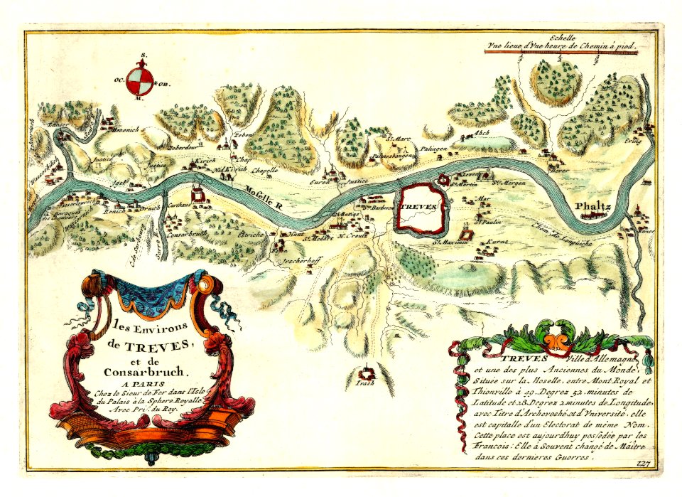
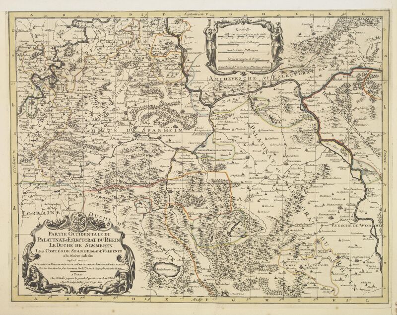
map of the circle of the rhineland by sanson
maps by nicolas sanson
maps from university of amsterdam special collections
atlas der neederlanden
maps of the palatinate of the rhine
1692 maps of rhineland-palatinate
sanson maps of north america
island of california
old maps of cologne
nicolaus person
maps by nicolas sanson
sanson maps of asia
old maps of the whole peloponnese
guillaume sanson
maps in the british museum
maps of naval battles
eran laor cartographic collection
sanson maps of asia
media contributed by cleveland public library
georg widmann
maps from university of amsterdam special collections
atlas der neederlanden
map of europe by guillaume sanson (1674)
bibliothèque nationale de france
maps from university of amsterdam special collections
atlas der neederlanden
eran laor cartographic collection
guillaume sanson
old maps of duchy of cleves
guillaume sanson
map collection of leibniz-institut für länderkunde
1690s maps of the iberian peninsula
maps of the palatinate of the rhine
1692 maps of rhineland-palatinate
l'espagne divisée by guillaume sanson
1690s maps of the iberian peninsula
geography
maps
maps from university of amsterdam special collections
atlas der neederlanden
recueil d'antiquités égyptiennes, étrusques, greques et romaines (1752)
18th-century maps of paris
maps of paris from the david rumsey historical map collection
map of paris by jouvin de rochefort (boutier 133)
bibliothèque nationale de france
guillaume sanson
cartography
maps
maps in the rijksmuseum amsterdam
1690s maps of the netherlands
cartography
maps
cartography
maps
17th-century maps of vienna
bartholomeo camuccio
eran laor cartographic collection
guillaume sanson
maps in the rijksmuseum amsterdam
1690s maps of belgium
recueil d'antiquités égyptiennes, étrusques, greques et romaines (1752)
18th-century maps of paris
françois harrewijn
rubenshuis in art
maps in the rijksmuseum amsterdam
abraham allard
british library king's topographical collection
william henry toms
recueil d'antiquités égyptiennes, étrusques, greques et romaines (1756)
18th-century maps of paris
recueil d'antiquités égyptiennes, étrusques, greques et romaines (1752)
18th-century maps of périgueux
maps in the rijksmuseum amsterdam
abraham allard
recueil d'antiquités égyptiennes, étrusques, greques et romaines (1756)
historical images of paris
maps in the rijksmuseum amsterdam
maps by carolus allard
prints of cartouches in the rijksmuseum amsterdam
maps in the rijksmuseum amsterdam
dutch 18th-century drawings in the rijksmuseum amsterdam
gerrit de broen jr. (1692-1774)
prints by franz ertinger in the rijksmuseum amsterdam
bequest of simon emmering
1 - 52 of 52
/ 1


![Alphabetical table of the names of towns, villages etc. which are on the map of Zeeland by Mr. Sanson ([1692]), [1692]](https://cdn.creazilla.com/illustrations/10000748056/alphabetical-table-of-the-names-of-towns-villages-etc-which-are-on-the-map-of-zeeland-by-mr-sanson-1692-1692-md.jpg)


![The County of Artois / drawn up on the most recent memories, by Mr. Sanson; dedicated to Monseigneur the dauphin, [1692]](https://cdn.creazilla.com/illustrations/10001313165/the-county-of-artois-drawn-up-on-the-most-recent-memories-by-mr-sanson-dedicated-to-monseigneur-the-dauphin-1692-md.jpg)

![The County of Zeelande / draws up new plans based on the memoirs by Mr. Sanson, ordinary geographer to the King, [1692]](https://cdn.creazilla.com/illustrations/10001468571/the-county-of-zeelande-draws-up-new-plans-based-on-the-memoirs-by-mr-sanson-ordinary-geographer-to-the-king-1692-md.jpg)


![Tables of the divisions of the seventeen provinces of the Netherlands / by Mr. Sanson, ordinary geographer to the King, [1692]](https://cdn.creazilla.com/illustrations/10000941957/tables-of-the-divisions-of-the-seventeen-provinces-of-the-netherlands-by-mr-sanson-ordinary-geographer-to-the-king-1692-sm.jpg)


![Vienna a Turcis obsessa, & Des dante a Christianis diberata. Scala Perticarum Rynlandicarum 100 [=Om; 062; 1: 6 000 environ]. Cum Privilegio Caesarea Sumptibus Authoris, Dome[ni]co Rossetti scul, Domenico Rossetti, 1692](https://cdn.creazilla.com/illustrations/10000857324/vienna-a-turcis-obsessa-des-dante-a-christianis-diberata-scala-perticarum-rynlandicarum-100-om-062-1-6-000-environ-cum-privilegio-caesarea-sumptibus-authoris-domenico-rossetti-scul-domenico-rossetti-1692-md.jpg)


