Log in
All resources
Create a design
27,441 Free Images of Maps
maps of africa
africa in the 1890s
maps from the earth and its inhabitants, vol. xii
maps from the earth and its inhabitants, vol. xiii
description de l'universe
alain manesson mallet
ateliers bmb mercator
eran laor cartographic collection
maps from the earth and its inhabitants, vol. xi
bibliothèque nationale de france
maps from the earth and its inhabitants, vol. xii
africa in the 1890s
maps from the earth and its inhabitants, vol. xiii
africa in the 1890s
maps from the earth and its inhabitants, vol. xi
africa in the 1890s
maps from the earth and its inhabitants, vol. xii
africa in the 1890s
maps from the earth and its inhabitants, vol. xii
africa in the 1890s
maps from the earth and its inhabitants, vol. xi
africa in the 1880s
maps from the earth and its inhabitants, vol. xii
africa in the 1890s
gemeente atlas van nederland - north holland
maps of beets, north holland
maps from the earth and its inhabitants, vol. xiii
africa in the 1890s
maps from the earth and its inhabitants, vol. xii
africa in the 1890s
maps from the earth and its inhabitants, vol. xiii
africa in the 1890s
maps from the earth and its inhabitants, vol. xi
africa in the 1890s
maps from the earth and its inhabitants, vol. xii
africa in the 1890s
maps from the earth and its inhabitants, vol. xi
africa in the 1890s
maps from the earth and its inhabitants, vol. xii
africa in the 1890s
maps from the earth and its inhabitants, vol. xiii
africa in the 1890s
maps from the earth and its inhabitants, vol. xii
africa in the 1890s
maps from the earth and its inhabitants, vol. xii
africa in the 1890s
maps from the earth and its inhabitants, vol. xi
africa in the 1890s
maps from the earth and its inhabitants, vol. xiii
africa in the 1890s
maps from the earth and its inhabitants, vol. xiii
maps of africa
maps from the earth and its inhabitants, vol. xiii
africa in the 1890s
maps from the earth and its inhabitants, vol. xi
africa in the 1890s
maps from the earth and its inhabitants, vol. xiii
africa in the 1890s
maps from the earth and its inhabitants, vol. xii
people of africa
maps from the earth and its inhabitants, vol. xiii
africa in the 1890s
maps from the earth and its inhabitants, vol. xiii
africa in the 1890s
maps from the earth and its inhabitants, vol. xiii
africa in the 1890s
maps from the earth and its inhabitants, vol. xiii
africa in the 1890s
curt teich postcard archives
map postcards
maps from the earth and its inhabitants, vol. xii
africa in the 1890s
maps from the earth and its inhabitants, vol. xii
africa in the 1890s
maps of stade
baroque
maps by jakob van der schley
old maps of southeast asia
maps of barth by braun & hogenberg
duchy of pomerania
maps of paris from the david rumsey historical map collection
environs de paris levés géométriquement by jean delagrive
maps of asia by mercator-hondius
ateliers bmb mercator
maps of cornwall and south wales by gerardus mercator
ateliers bmb mercator
maps of north england by gerardus mercator
ateliers bmb mercator
maps of europe by mercator-hondius
ateliers bmb mercator
maps of the british isles by gerardus mercator
ateliers bmb mercator
maps of the americas by mercator-hondius
ateliers bmb mercator
maps of africa by mercator-hondius
ateliers bmb mercator
eran laor cartographic collection
joan blaeu
engravings of topographia austriacarum
baroque
curt teich postcard archives, curt teich & company
map postcards
eran laor cartographic collection
baroque
lorens pasch the younger
rococo
18th-century maps of corsica
maps by thomas kitchin
a new map of the island of tobago... - by tho.s kitchin... - btv1b53121990k
maps by thomas kitchin
a new map of the island of tobago... - by tho.s kitchin... - btv1b53121990k
maps by thomas kitchin
description de l'universe
1683 prints
description de l'universe
man in the moon
description de l'universe
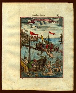
africa in art
description de l'universe
mythological cetaceans
description de l'universe
corals
description de l'universe
1685 in spain
maps of goa by linschoten
baroque
description de l'universe
history of chile
asia noviter delineata
1617 drawings
in the volcanic eifel. a holiday ramble (1896)
old maps of eifel
the cruise of the marchesa (1889)
kamchatka oblast
description de l'universe
history of madrid
david rumsey historical map collection
old maps of the holy roman empire
maps of abyssinia by mercator-hondius
map of amsterdam by gerrit de broen (ii)
maps in the stadsarchief amsterdam
maps of cambridge by braun & hogenberg
1575 maps of england
maps from the earth and its inhabitants, vol. xiv
blitar
redeeming the republic (1890)
1890s maps showing history
maps from the earth and its inhabitants, vol. xviii
llanquihue
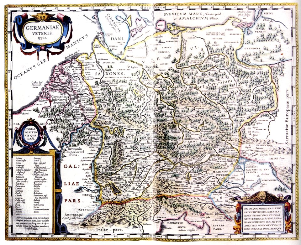
atlas maior, vol 3 (germany) - joan blaeu, 1667 - bl 114.h(star).3
johannes gigas
maps from university of amsterdam special collections
atlas der neederlanden
paintings in the museo correr
gian battista arzenti
gemeente atlas van nederland - utrecht
old maps of amersfoort
maps in the national library of scotland
blaeu atlas of scotland 1654
maps of hamburg by braun & hogenberg
maps of lübeck by braun & hogenberg
mercator 1587 world map
maps by jodocus hondius
old maps of the nile delta
1850s maps of egypt
shadows of the east; or, slight sketches of scenery, persons and customs, from observations during a tour in 1853 and 1854, in egypt, palestine, syria, turkey, and greece (1855) by tobin
maps of upper egypt
shadows of the east; or, slight sketches of scenery, persons and customs, from observations during a tour in 1853 and 1854, in egypt, palestine, syria, turkey, and greece (1855) by tobin
1850s maps of palestine
shadows of the east; or, slight sketches of scenery, persons and customs, from observations during a tour in 1853 and 1854, in egypt, palestine, syria, turkey, and greece (1855) by tobin
1850s maps of palestine
shadows of the east; or, slight sketches of scenery, persons and customs, from observations during a tour in 1853 and 1854, in egypt, palestine, syria, turkey, and greece (1855) by tobin
1855 maps of spain
people with maps in art
posters of germany
eran laor cartographic collection
joachim ottens
maps of groningen by braun & hogenberg
history of martinikerk (groningen)
eran laor cartographic collection
adolf eltzner
russian empire in thomas kitchen's general atlas (1773)
general atlas (1773)
hamburgische elbkarte von melchior lorichs
melchior lorck
eran laor cartographic collection
guillaume sanson
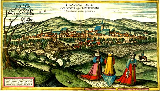
maps of cluj-napoca by braun & hogenberg
cluj-napoca
collections of prädikantenbibliothek isny
maps by willem and johannes blaeu
media from regionaal archief alkmaar
zijpe
maps of the west-indische compagnie
1665
eran laor cartographic collection
lucas janszoon waghenaer
1640s maps of hesse
old maps of nassau
maps from the mechanical curator collection
balaton albuma (1851) by szerelmey
eran laor cartographic collection
jacob peeters
old maps of alexandria
louis-françois cassas
maps from the earth and its inhabitants, vol. xii
africa in the 1890s
1640s maps of the americas
copper engravings
8501 - 8600 of 27,441
Next page
/ 275