Log in
All resources
Create a design
27,441 Free Images of Maps
maps in the library of congress
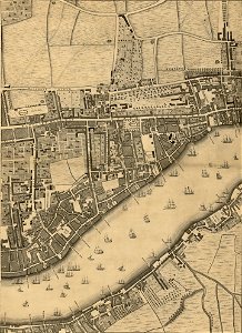
john rocque 1746 crops from library of congress
john rocque's maps of london
john rocque
bibliothèque nationale de france
description de l'universe
alain manesson mallet
eran laor cartographic collection
turgot map of paris, david rumsey historical map collection – derivative files
latin-language maps
john rocque 1746 crops from library of congress
maps in the library of congress
john rocque 1746 crops from library of congress
maps in the library of congress
john rocque 1746 crops from library of congress
maps in the library of congress
john rocque 1746 crops from library of congress
maps in the library of congress
john rocque 1746 crops from library of congress
maps in the library of congress
john rocque 1746 crops from library of congress
maps in the library of congress
john rocque 1746 crops from library of congress
maps in the library of congress
john rocque 1746 crops from library of congress
maps in the library of congress
a map of the british empire in america with the french and spanish settlements adjacent thereto
1730s maps of the caribbean
maps in the library of congress
1750s maps of the americas
geological maps of england
william smith (geologist)
john rocque 1746 crops from library of congress
maps in the library of congress
john rocque 1746 crops from library of congress
maps in the library of congress
maps of peñón de vélez by braun & hogenberg
maps of tunis by braun & hogenberg
john rocque 1746 crops from library of congress
maps in the library of congress
john rocque 1746 crops from library of congress
maps in the library of congress
john rocque 1746 crops from library of congress
maps in the library of congress
john rocque 1746 crops from library of congress
maps in the library of congress
john rocque 1746 crops from library of congress
maps in the library of congress
maps in the library of congress
1708 maps
john rocque 1746 crops from library of congress
maps in the library of congress
john rocque 1746 crops from library of congress
maps in the library of congress
drawings by james mcneill whistler in the metropolitan museum of art
aestheticism
prints by abraham allard in the rijksmuseum amsterdam
maps in the rijksmuseum amsterdam
a treatise on ore deposits (1896)
1890s maps of saxony
french-language maps of south africa
1876 maps of africa
maps from the earth and its inhabitants, vol. iv
old maps of kingston upon hull
1876 maps of north america
1876 maps of the caribbean
picturesque burma, past and present (1897)
1890s maps showing history
1876 maps of the united states
old maps of new england
maps from the earth and its inhabitants, vol. iv
old maps of the east riding of yorkshire
nouveau cours d'instruction primaire de géographie (1886)
1886 maps of france
with the armies of the balkans and at gallipoli (1880)
battle of gallipoli
historical images of the hôtel de soubise
hôtel de rohan
1777 maps of south america
maps by thomas kitchin
maps by nicolaes visscher i
17th-century maps of russia
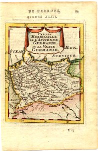
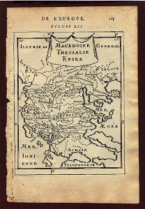
description de l'universe
1680s maps of germany
description de l'universe
1683 maps of europe
description de l'universe
1685 maps of europe
description de l'universe
1685 maps of europe
17th-century maps of europe
description de l'universe
châlons-en-champagne in the 17th century
hugues picart
maps by pieter van der keere
old maps of liège (province)
truscott map of st-petersburg 1753
engraved maps of saint petersburg
maps in the staats- und universitätsbibliothek hamburg
1670s maps of hamburg
maps by thomas kitchin
1780 maps of africa
maps in the staats- und universitätsbibliothek hamburg
1670s maps of hamburg
ismailïa. a narrative of the expedition to central africa for the suppression of the slave trade (1874)
nyanza, rwanda
coats of arms of perpignan
baroque painting,baroque
turgot map of paris, david rumsey historical map collection – derivative files
couvent des célestins (paris)
hendrik van langren map of south asia
1596 maps of asia
maps by willem and johannes blaeu
old maps of the danube
1870s maps of the caucasus
g. h. swanston
1870s maps of the caucasus
g. h. swanston
maps from university of amsterdam special collections
atlas der neederlanden
maps by tomas lopez
1772 maps of asia
bibliothèque nationale de france
fra mauro map derivative works
maps of the dutch east india company - south africa
1753 maps of africa
maps of the dutch east india company - mauritius
1753 maps of africa
maps of the dutch east india company - sri lanka
1787
old maps of plymouth and devonport
16th-century maps of england
dutch baroque architecture
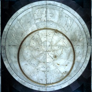
planispheres
eran laor cartographic collection
joan blaeu
eran laor cartographic collection
johann ulrich krauß
tourism advertising posters of germany
1935 maps of germany
eran laor cartographic collection
étienne dupérac
eran laor cartographic collection
joan blaeu
eran laor cartographic collection
baroque
bird's eye view of knoxville, tennessee, 1886
maps in the library of congress
19th-century maps of maastricht
maps in hcl (maastricht)
1803 maps of the caribbean
maps by john cary
cities in the 1640s
baroque
maps of kodagu district
edward weller
map of ghent by jan blaeu
maps of paradise by mercator-hondius
classicism
select views in india, drawn on the spot, in the years 1780, 1781, 1782, and 1783
british library asia, pacific and africa collections
maps of paris from the david rumsey historical map collection
maps of île-de-france by françois de la guillotière
gemeente atlas van nederland - south holland
19th-century maps of rotterdam
map collection of leibniz-institut für länderkunde
maps of limburg by aegidius martini
map collection of leibniz-institut für länderkunde
maps of limburg by aegidius martini
maps of the dutch east india company - sri lanka
1785
maps of augsburg by braun & hogenberg
1600s maps of augsburg
old maps of enkhuizen
atlas van loon
gommarus wouters
cornelis meijer
parts of old maps of bremen
baroque
harry's island
charles relyea
turgot map of paris, david rumsey historical map collection – derivative files
église saint-hippolyte (paris)
turgot map of paris, david rumsey historical map collection – derivative files
historical images of bièvre river in paris
old maps of the british empire
illustrations by walter crane
turgot map of paris, david rumsey historical map collection – derivative files
collégiale saint-marcel (paris)
a voyage to abyssinia, and travels into the interior of that country, executed under the orders of the british government in the years 1809 & 1810
john outhett
dr. wilh. junker's reisen in afrika 1875-1886
old maps of khartoum
cartes de franz schrader
1894 maps of france
dr. wilh. junker's reisen in afrika 1875-1886
19th-century maps of south sudan
maps of the ottoman empire by mercator-hondius
persian gulf naming dispute
stamps of french west africa
antoine de saint-exupéry
dr. wilh. junker's reisen in afrika 1875-1886
19th-century maps of south sudan
haseldorfer marsch
pinnau
cartes generales de toutes les parties du monde (1658)
1658 maps of asia
maps by jacques chiquet
1719 maps of africa
7301 - 7400 of 27,441
Next page
/ 275