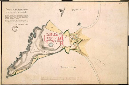
According to the leupe catalogue (na), the original title reads: project tot beter bevestiging van 't fort trinconomalé en de daaragter geleegene pagoodsberg. Map of the new fortifications to bolster the fort of trinconomale between the city and the northern and southern bays. Notes in leupe catalogue: behoort bij het rapport van de militaire staatscommissie naar de oost o. L. V. J. O. Vaillant, c. A. Ver huell en j. F. Van gravenstein. Zie voor rapport: na stadhouderlijke secretarie, inv. Nrs. 1910-1932, collectei verhuell inv. Nrs, 7-45. Notes on reverse: [blue label odg] nr. : 35 verbetering van trinconomale. Etiket nr. 553. Date: 1785. Dimensions: height: 53 cm (20.8 in); width: 35 cm (13.7 in). Medium: coloured drawing on paper. Collection: Nationaal Archief. AMH-4503-NA Map of the fort at Trinconomale
Loading...