Log in
All resources
Create a design
27,441 Free Images of Maps
joan blaeu
copper engraving print
british library
bibliothèque nationale de france
maps of spain by tomas lopez
1667 maps
description de l'universe
alain manesson mallet
gemeente atlas van nederland - south holland
1860s maps of south holland
atlas maior, vol 12 (america) - joan blaeu, 1667 - bl 114.h(star).12
1667 maps
atlas maior, vol 9 (italy) - joan blaeu, 1667 - bl 114.h(star).9
1667 maps of italy
atlas maior, vol 5 (england) - joan blaeu, 1667 - bl 114.h(star).5
17th-century maps of rutland
atlas maior, vol 3 (germany) - joan blaeu, 1667 - bl 114.h(star).3
old maps of moravia
atlas maior, vol 6 (scotland and ireland) - joan blaeu, 1667 - bl 114.h(star).6
1667 maps
atlas maior, vol 7 (france i) - joan blaeu, 1667 - bl 114.h(star).7
1667 maps
atlas maior, vol 10 (spain and africa) - joan blaeu, 1667 - bl 114.h(star).10
1667 maps
atlas maior, vol 5 (england) - joan blaeu, 1667 - bl 114.h(star).5
17th-century maps of lincolnshire
atlas maior, vol 5 (england) - joan blaeu, 1667 - bl 114.h(star).5
17th-century maps of westmorland
atlas maior, vol 5 (england) - joan blaeu, 1667 - bl 114.h(star).5
17th-century maps of essex
atlas maior, vol 6 (scotland and ireland) - joan blaeu, 1667 - bl 114.h(star).6
1667 maps
atlas maior, vol 6 (scotland and ireland) - joan blaeu, 1667 - bl 114.h(star).6
1667 maps
maps of the palatinate of the rhine
1692 maps of rhineland-palatinate
atlas maior, vol 4 (netherlands) - joan blaeu, 1667 - bl 114.h(star).4
1667 maps
atlas maior, vol 6 (scotland and ireland) - joan blaeu, 1667 - bl 114.h(star).6
1667 maps
maps by willem and johannes blaeu
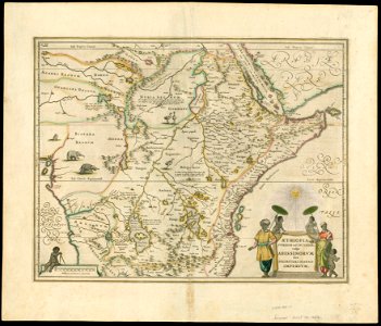
1650s maps of ethiopia
maps from the earth and its inhabitants, vol. x
maps of damietta
gemeente atlas van nederland - north holland
maps of beemster
gemeente atlas van nederland - south holland
maps of lisse
maps from the earth and its inhabitants, vol. x
19th-century maps of africa
historisk atlas (stockholm, norstedt & söner, 1880)
maps of 13th-century greece
locator maps of municipalities of north holland
maps of anna paulowna
maps of bruges by jacques harrewijn
maps of tintin
borduria
andalusia in the 1610s
francisco heylan
maps of spain by tomas lopez
1782 maps of spain
18th-century maps of north africa
maps by tomas lopez
maps in the british museum
1780s maps of france
maps of spain by tomas lopez
1773 maps of spain
maps of spain by tomas lopez
1779 maps of spain
maps of spain by tomas lopez
1779 maps of spain
maps of spain by tomas lopez
1782 maps of spain
maps of spain by tomas lopez
1779 maps of spain
maps of spain by tomas lopez
1779 maps of spain
old maps of tenerife
1779 maps of spain
maps of spain by tomas lopez
1773 maps of spain
old maps of the british empire
illustrations by walter crane
1771 maps of north america
multilingual maps
maps in the library of congress
1889 maps of new york (state)
maps by johannes vingboons
old maps of asia
media from regionaal archief alkmaar
old maps of north holland
prints by mario cartaro
old maps of jerusalem
arnold van langren map of southwest africa
1600 maps of africa
1700s maps of germany
battle of blenheim
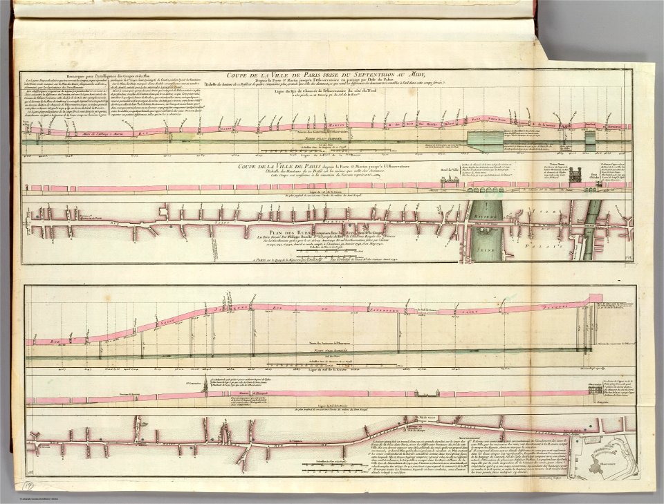
old submaps of paris
philippe buache
maps of the dutch east india company - madagascar
1705
17th-century maps of paris
baroque
drawings in the museu antônio parreiras
paper and graphite
drawings in the museu antônio parreiras
paper and graphite
drawings in the museu antônio parreiras
paper and charcoal
map of paris by braun & hogenberg - derivative files
rue des archives (paris)
brazilian paintings in the museu antônio parreiras
paper and engraving
maps of paris from paris musées
baroque
drawings in the museu antônio parreiras
paper and graphite
19th-century maps of seine-et-marne
coats of arms of seine-et-marne
coats of arms of cities in haute-loire
marquis de lafayette in art
georges-louis leclerc, comte de buffon
coats of arms of dijon
coats of arms of auch
old maps of gers
coats of arms of cities in doubs
bon adrien jeannot de moncey
coats of arms of cities in vaucluse
jean-sifrein maury
adolf eltzner, svate mesto jerusalem za casu krista pana, 1864
eran laor cartographic collection
adolf eltzner, svate mesto jerusalem za casu krista pana, 1864
eran laor cartographic collection
maps in the british museum
old maps of chester
eran laor cartographic collection
daniel friedrich sotzmann
17th-century maps of silesia
coats of arms on maps
adolf eltzner, svate mesto jerusalem za casu krista pana, 1864
eran laor cartographic collection
eran laor cartographic collection
guillaume dheulland
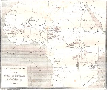
illustrations from five weeks in a balloon by riou and montaut
orientalist painting
maps of hamburg by braun & hogenberg
maps of hamburg-altstadt
1375 maps of europe
catalan atlas
1375 maps of europe
catalan atlas
maps of the forest of fontainebleau
old maps of seine-et-marne
maps of mons city walls (hainaut)
old maps of mons (hainaut)
description de l'universe
old maps of karpathos
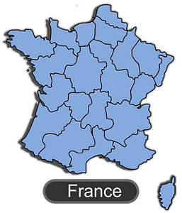
france
maps
gerardus mercator
jodocus hondius
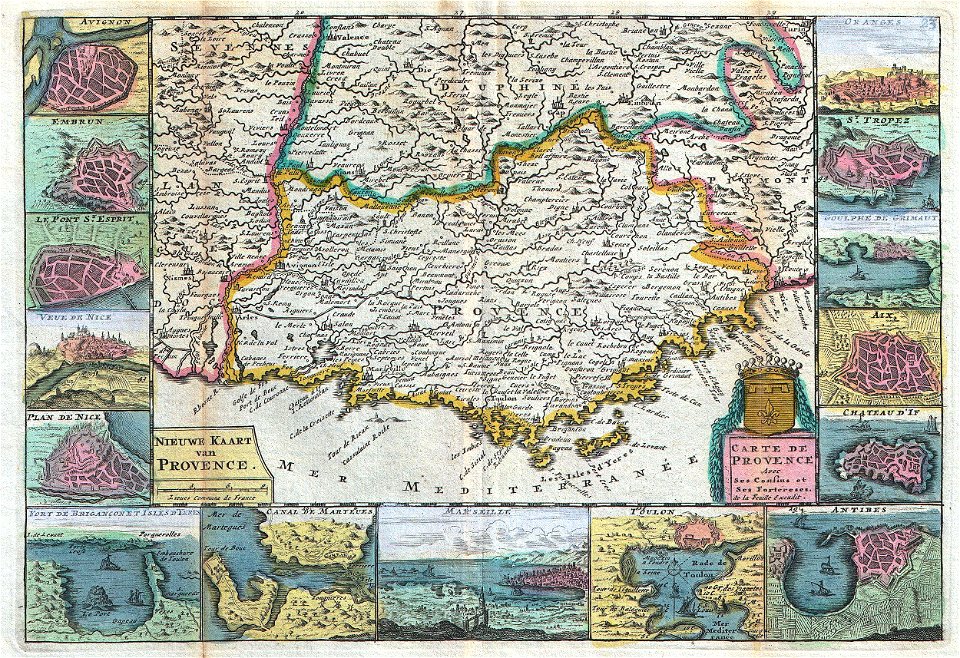
old maps of provence
1747 maps of france
maps of castile by mercator-hondius
details of old maps
maps of liège in the 18th century
jacobus harrewijn
17th-century maps of italy
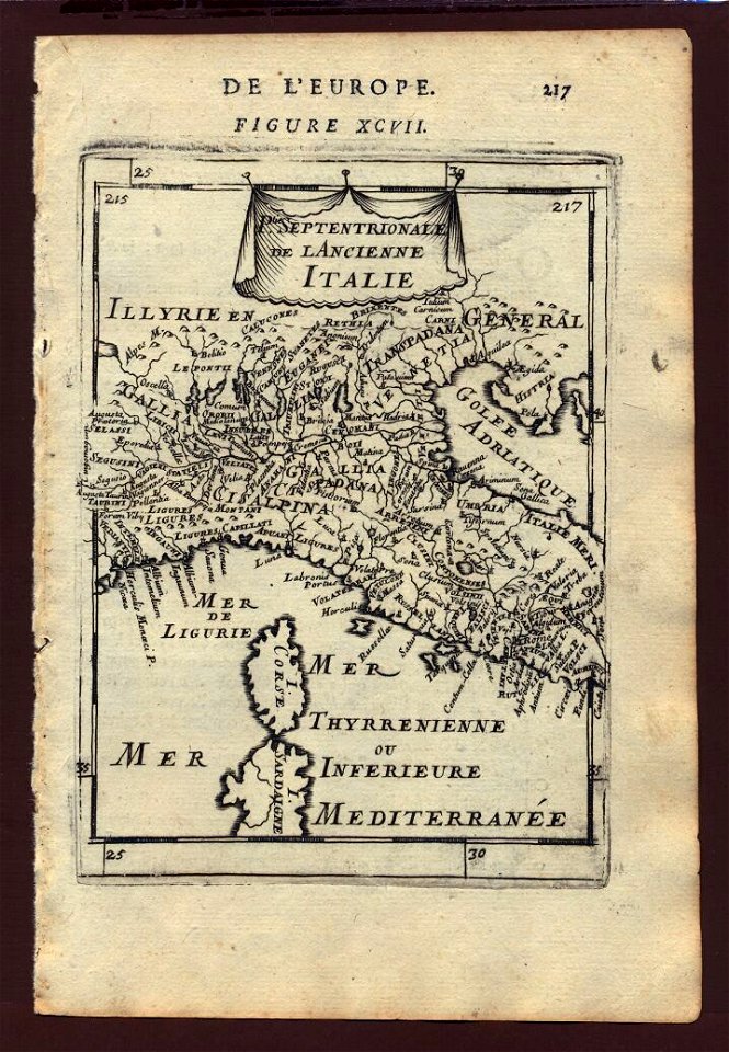
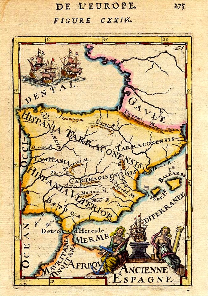
description de l'universe
1680s maps of the iberian peninsula
description de l'universe
description de l'universe
1680s maps of italy
17th-century maps of italy
description de l'universe
17th-century maps of the iberian peninsula
description de l'universe
description de l'universe
1685 maps of europe
den danske hærs historie til nutiden og den norske hærs historie indtil 1814
maps from the mechanical curator collection
gemeente atlas van nederland - south holland
1860s maps of south holland
gemeente atlas van nederland - north holland
old maps of haarlem
gemeente atlas van nederland - south holland
1860s maps of south holland
gemeente atlas van nederland - south holland
1860s maps of south holland
gemeente atlas van nederland - south holland
1860s maps of south holland
gemeente atlas van nederland - south holland
maps of zegwaart
maps from the earth and its inhabitants, vol. xii
africa in the 1890s
maps from the earth and its inhabitants, vol. xii
canary islands in the 1890s
great fire of 1866 in quebec city
19th-century maps of quebec city
considérations géographiques et physiques sur les nouvelles découvertes au nord de la grande mer
hokkaido in art
old county maps of hertfordshire
maps by thomas kitchin
guide joanne normandie-1912
french-language maps
turgot map of paris, kyoto university library – derivative files
hôtel de condé
hamburgische elbkarte von melchior lorichs
parts of old maps of hamburg
5201 - 5300 of 27,441
Next page
/ 275