Log in
All resources
Create a design
27,441 Free Images of Maps
copper engraving print
british library
joan blaeu
1667 maps
atlas maior, vol 5 (england) - joan blaeu, 1667 - bl 114.h(star).5
atlas maior, vol 6 (scotland and ireland) - joan blaeu, 1667 - bl 114.h(star).6
bibliothèque nationale de france
maps from the earth and its inhabitants, vol. iv
atlas maior, vol 12 (america) - joan blaeu, 1667 - bl 114.h(star).12
maps from the earth and its inhabitants, vol. xiii
watercolor drawings by johannes vingboons
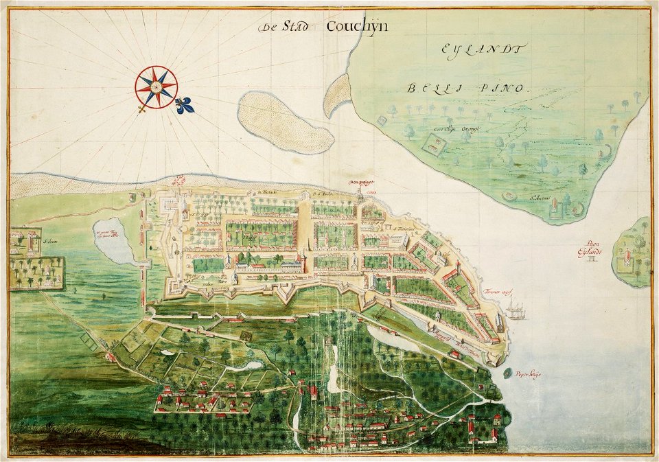
old maps of kochi, kerala
maps by alexis-hubert jaillot
maps by guillaume sanson
eran laor cartographic collection
pierre mortier
map of the circle of austria by sanson
1670s maps of austria
maps of the basque autonomous community
1770 maps of spain
maps by jan eduard wagner
františek kytka
map of the circle of austria by sanson
1670s maps of austria
alessandro baratta
old maps of genoa
description de l'universe
1685 maps of europe
old maps of ghent by jacques horenbault
old maps of sint-elisabethbegijnhof
daniel de la feuille
1747 maps of belgium
gemeente atlas van nederland - utrecht
ruwiel
maps showing 19th-century history
1812 maps of africa
eran laor cartographic collection
willem albert bachiene
maps from the earth and its inhabitants, vol. ix
maps of telegraph lines
maps from the earth and its inhabitants, vol. iv
maps of portland, england
maps from the earth and its inhabitants, vol. viii
demographic maps of thailand
maps from the earth and its inhabitants, vol. xiii
ethnographic maps of africa
maps from the earth and its inhabitants, vol. vii
maps of xuanzang's travels
old maps of south africa
maps of the great trek
maps from the earth and its inhabitants, vol. iv
maps of loch fyne
maps from the earth and its inhabitants, vol. vii
maps of the yellow river
maps from the earth and its inhabitants, vol. iv
mouth of tay
maps from the earth and its inhabitants, vol. x
19th-century maps of egypt
maps of rivers of senegal
bafing river
maps from the earth and its inhabitants, vol. xi
maps indicating exploration
maps from the earth and its inhabitants, vol. xv
maps indicating exploration
maps from the earth and its inhabitants, vol. xii
maps of icebergs
maps from the earth and its inhabitants, vol. iv
maps of kirkwall
maps of the western cape
breede river
gemeente atlas van nederland - drenthe
drenthe
gemeente atlas van nederland - south holland
1860s maps of south holland
topographia westphaliae (merian)
baroque
old maps of delfzijl
atlas van loon
maps of the islands of greece by marco boschini (1658)
old maps of tenedos
maps of kozhikode by braun & hogenberg
maps of elmina by braun & hogenberg
maps of philippeville by braun & hogenberg
maps of mariembourg by braun & hogenberg
1572 maps of africa
1570s maps of egypt
maps of salzburg by braun & hogenberg
maps of ulm by braun & hogenberg
maps of franconia by gerardus mercator
1640s maps of bavaria
1739 maps of france
plan de turgot
maps by christian sgrothen
old maps of utrecht
maps in the library of congress
1852 maps
maps in the library of congress
1856 maps of philadelphia
charts and maps of the royal museums greenwich
1590 maps
nouvelle géographie universelle, vol. xii
charles eugène perron
nouvelle géographie universelle, vol. xii
charles eugène perron
map of expo 1913
expo 1913
atlas maior, vol 6 (scotland and ireland) - joan blaeu, 1667 - bl 114.h(star).6
1667 maps
atlas maior, vol 5 (england) - joan blaeu, 1667 - bl 114.h(star).5
17th-century maps of northamptonshire
atlas maior, vol 6 (scotland and ireland) - joan blaeu, 1667 - bl 114.h(star).6
1667 maps
prints by ambrogio brambilla
maps in the british museum
atlas maior, vol 6 (scotland and ireland) - joan blaeu, 1667 - bl 114.h(star).6
1667 maps
atlas maior, vol 5 (england) - joan blaeu, 1667 - bl 114.h(star).5
17th-century maps of lancashire
atlas maior, vol 10 (spain and africa) - joan blaeu, 1667 - bl 114.h(star).10
1667 maps
atlas maior, vol 5 (england) - joan blaeu, 1667 - bl 114.h(star).5
17th-century maps of radnorshire
atlas maior, vol 12 (america) - joan blaeu, 1667 - bl 114.h(star).12
1667 maps
atlas maior, vol 5 (england) - joan blaeu, 1667 - bl 114.h(star).5
17th-century maps of leicestershire
atlas maior, vol 7 (france i) - joan blaeu, 1667 - bl 114.h(star).7
1667 maps
atlas maior, vol 5 (england) - joan blaeu, 1667 - bl 114.h(star).5
17th-century maps of brecknockshire
atlas maior, vol 5 (england) - joan blaeu, 1667 - bl 114.h(star).5
17th-century maps of staffordshire
atlas maior, vol 6 (scotland and ireland) - joan blaeu, 1667 - bl 114.h(star).6
1667 maps
atlas maior, vol 3 (germany) - joan blaeu, 1667 - bl 114.h(star).3
maps by wolfgang lazius
atlas maior, vol 6 (scotland and ireland) - joan blaeu, 1667 - bl 114.h(star).6
1667 maps
atlas maior, vol 6 (scotland and ireland) - joan blaeu, 1667 - bl 114.h(star).6
1667 maps
atlas maior, vol 9 (italy) - joan blaeu, 1667 - bl 114.h(star).9
1667 maps of italy
atlas maior, vol 5 (england) - joan blaeu, 1667 - bl 114.h(star).5
17th-century maps of yorkshire
atlas maior, vol 5 (england) - joan blaeu, 1667 - bl 114.h(star).5
17th-century maps of glamorgan
atlas maior, vol 9 (italy) - joan blaeu, 1667 - bl 114.h(star).9
1667 maps of italy
atlas maior, vol 6 (scotland and ireland) - joan blaeu, 1667 - bl 114.h(star).6
1667 maps
atlas maior, vol 12 (america) - joan blaeu, 1667 - bl 114.h(star).12
1667 maps
atlas maior, vol 11 (asia) - joan blaeu, 1667 - bl 114.h(star).11
1667 maps
atlas maior, vol 6 (scotland and ireland) - joan blaeu, 1667 - bl 114.h(star).6
1667 maps
atlas maior, vol 6 (scotland and ireland) - joan blaeu, 1667 - bl 114.h(star).6
1667 maps
atlas maior, vol 12 (america) - joan blaeu, 1667 - bl 114.h(star).12
1667 maps
atlas maior, vol 6 (scotland and ireland) - joan blaeu, 1667 - bl 114.h(star).6
1667 maps
atlas maior, vol 6 (scotland and ireland) - joan blaeu, 1667 - bl 114.h(star).6
1667 maps
atlas maior, vol 5 (england) - joan blaeu, 1667 - bl 114.h(star).5
1660s maps of wales
1660s maps of spain
1667 maps
atlas maior, vol 6 (scotland and ireland) - joan blaeu, 1667 - bl 114.h(star).6
1667 maps
atlas maior, vol 5 (england) - joan blaeu, 1667 - bl 114.h(star).5
17th-century maps of monmouthshire
atlas maior, vol 5 (england) - joan blaeu, 1667 - bl 114.h(star).5
17th-century maps of northumberland
atlas maior, vol 11 (asia) - joan blaeu, 1667 - bl 114.h(star).11
1667 maps
atlas maior, vol 5 (england) - joan blaeu, 1667 - bl 114.h(star).5
17th-century maps of middlesex
atlas maior, vol 5 (england) - joan blaeu, 1667 - bl 114.h(star).5
17th-century maps of hertfordshire
atlas maior, vol 5 (england) - joan blaeu, 1667 - bl 114.h(star).5
17th-century maps of shropshire
atlas maior, vol 9 (italy) - joan blaeu, 1667 - bl 114.h(star).9
1667 maps of italy
atlas maior, vol 5 (england) - joan blaeu, 1667 - bl 114.h(star).5
17th-century maps of derbyshire
atlas maior, vol 6 (scotland and ireland) - joan blaeu, 1667 - bl 114.h(star).6
1667 maps
atlas maior, vol 11 (asia) - joan blaeu, 1667 - bl 114.h(star).11
1667 maps
atlas maior, vol 5 (england) - joan blaeu, 1667 - bl 114.h(star).5
17th-century maps of herefordshire
atlas maior, vol 5 (england) - joan blaeu, 1667 - bl 114.h(star).5
17th-century maps of huntingdonshire
atlas maior, vol 5 (england) - joan blaeu, 1667 - bl 114.h(star).5
17th-century maps of cambridgeshire
atlas maior, vol 5 (england) - joan blaeu, 1667 - bl 114.h(star).5
17th-century maps of nottinghamshire
atlas maior, vol 5 (england) - joan blaeu, 1667 - bl 114.h(star).5
17th-century maps of oxfordshire
atlas maior, vol 1 (northern europe, norway, and denmark) - joan blaeu, 1667 - bl 114.h(star).1
1667 maps
atlas maior, vol 12 (america) - joan blaeu, 1667 - bl 114.h(star).12
1667 maps
atlas maior, vol 5 (england) - joan blaeu, 1667 - bl 114.h(star).5
17th-century maps of somerset
atlas maior, vol 6 (scotland and ireland) - joan blaeu, 1667 - bl 114.h(star).6
1667 maps
atlas maior, vol 5 (england) - joan blaeu, 1667 - bl 114.h(star).5
old maps of the channel islands
5101 - 5200 of 27,441
Next page
/ 275