7 Sup Hol 1573 Sgrooten

7 Sup Hol 1573 Sgrooten

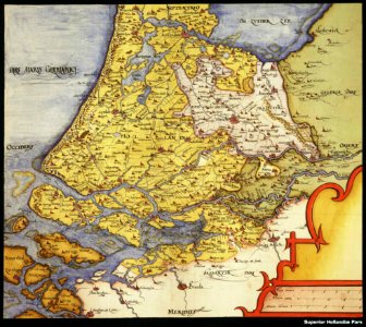
Detail of a 16th-century map showing south holland and the prince-bishopric of utrecht ("episcopatus traiecten", in white), more precisely the part of the prince-bishopric known as nedersticht utrecht (lower utrecht) centered on the city of utrecht ("vtrycht"). Date: 1573.
Edit image
Published by:
Creazilla
Author: Sgrooten, ChristiaanSource: commons.wikimedia.org

Loading...

0 downloads
Loading...
old maps of utrechtmaps by christian sgrothenold maps of south holland

MORE LIKE THIS

Creazilla logo
Over 10 million free graphic resources for content creators and designers.
© 2018 - 2025 Creazilla
Our resourcesAll imagesPhotosDigital illustrationsClipartIconsPNG ImagesEmojisSilhouettesTraditional Art3D ModelsVectorsFontsColor namesColor palettesGradientsAudioAnimationVideosTemplates
InformationAbout CreazillaTerms of useTech teamPrivacy policyLicence Information
FeedbackContact Us