Log in
All resources
Create a design
475 Free Images of 1860 Maps
gemeente atlas van nederland - south holland
1860s maps of south holland
19th-century maps of rotterdam
gemeente atlas van nederland - north holland
1860s maps of north holland
netherlands in the 1860s
rotterdam in the 1860s
molenlanden in the 1860s
published by frans buffa & zonen
maps in the rijksmuseum amsterdam
maps of the elbe
alster (river)
history of visualization
dot maps
sugawara michizane
ukiyo-e
19th-century portrait paintings in the musée national du château de versailles
jean-adolphe beaucé
maps of del norte county, california
1866 maps of california
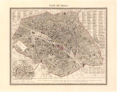
bird's-eye views of paris
1860 in paris
bird's-eye views of paris
1860 in paris
portrait paintings by alexandre cabanel
academic art
1860s maps of palestine
al-salihiyya
istván széchenyi
thonet furniture
media from the national library of finland
classicism
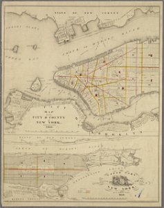
1895 maps of new york (state)
old maps of albany, new york
gemeente atlas van nederland - north holland
maps of haarlemmerliede en spaarnwoude
maps in the library of congress
fortifications of port hudson
vue (en relief et à vol d'oiseau) de paris by jacques-alphonse testard
maps of paris from bibliothèque nationale de france
gemeente atlas van nederland - south holland
maps of peursum
maps in the rijksmuseum amsterdam
published by frans buffa & zonen
maps in the rijksmuseum amsterdam
published by frans buffa & zonen
gemeente atlas van nederland - south holland
maps of zoeterwoude
gemeente atlas van nederland - north holland
19th-century maps of amsterdam
gemeente atlas van nederland - south holland
1860s maps of south holland
gemeente atlas van nederland - south holland
1860s maps of south holland
gemeente atlas van nederland - south holland
19th-century maps of rotterdam
gemeente atlas van nederland - south holland
19th-century maps of rotterdam
media from the national library of finland
classicism
19th-century maps of south holland
maps of veur
maps in the rijksmuseum amsterdam
published by frans buffa & zonen
19th-century maps of russia
russia in the 1860s
noordzeekanaal
maps of velsen
admiralty charts 2601-2800
sligo bay
gemeente atlas van nederland - south holland
maps of hillegom
gemeente atlas van nederland - north holland
maps of haarlemmermeer
manual of the corporation of the city of new york (1860)
maps from valentine's manual
maps of paris in the 1860s
1860s maps of paris
19th-century maps of russia
russia in the 1860s
portrait paintings by michele gordigiani
scapigliatura
gemeente atlas van nederland - north holland
maps of aalsmeer
gemeente atlas van nederland - south holland
maps of noordeloos
gemeente atlas van nederland - north holland
19th-century maps of amsterdam
gemeente atlas van nederland - north holland
amsterdam in the 1860s
1860s maps of new york (state)
maps showing 1776
gemeente atlas van nederland - south holland
19th-century maps of rotterdam
cornell's primary geography (1860)
1867 maps of canada
maps in the rijksmuseum amsterdam
published by frans buffa & zonen
maps in the rijksmuseum amsterdam
published by frans buffa & zonen
gemeente atlas van nederland - south holland
1860s maps of south holland
maps from the mechanical curator collection available to georeference
maps from the mechanical curator collection
admiralty charts 2601-2800
tralee
old maps of england
1860 maps
gemeente atlas van nederland - south holland
maps of zuidland
gemeente atlas van nederland - south holland
19th-century maps of rotterdam
media from the national library of finland
classicism
gemeente atlas van nederland - south holland
hugo suringar
gemeente atlas van nederland - south holland
maps of alblasserdam
history of yokohama
maps of yokohama
gemeente atlas van nederland - south holland
old maps of katwijk, south holland
maps of nieuwpoort, south-holland
vestingwerken nieuwpoort
gemeente atlas van nederland - south holland
19th-century maps of rotterdam
kaart van suriname naar opmetingen gedaan in de jaren 1860-1879
albina, suriname
gemeente atlas van nederland - south holland
1860s maps of south holland
gemeente atlas van nederland - south holland
old maps of the hague
gemeente atlas van nederland - south holland
19th-century maps of rotterdam
gemeente atlas van nederland - south holland
maps of wateringen
gemeente atlas van nederland - south holland
1860s maps of south holland
gemeente atlas van nederland - south holland
1860s maps of south holland
gemeente atlas van nederland - south holland
1860s maps of south holland
19th-century maps of the ottoman empire
maps in the british museum
gemeente atlas van nederland - south holland
maps of krimpen aan den ijssel
gemeente atlas van nederland - south holland
old maps of brielle
gemeente atlas van nederland - south holland
maps of heenvliet
gemeente atlas van nederland - south holland
maps of groot-ammers
gemeente atlas van nederland - south holland
maps of 's-gravenzande
gemeente atlas van nederland - south holland
1860s maps of south holland
gemeente atlas van nederland - gelderland
netherlands in the 1860s
gemeente atlas van nederland - north holland
old maps of beverwijk
gemeente atlas van nederland - south holland
maps of hellevoetsluis
gemeente atlas van nederland - south holland
maps of westmaas
gemeente atlas van nederland - south holland
19th-century maps of rotterdam
gemeente atlas van nederland - south holland
maps of loosduinen
gemeente atlas van nederland - south holland
old maps of gorinchem
gemeente atlas van nederland - south holland
old maps of dordrecht
gemeente atlas van nederland - south holland
maps of maassluis
gemeente atlas van nederland - south holland
1860s maps of south holland
gemeente atlas van nederland - south holland
1860s maps of south holland
gemeente atlas van nederland - south holland
19th-century maps of rotterdam
gemeente atlas van nederland - south holland
1860s maps of south holland
gemeente atlas van nederland - south holland
1860s maps of south holland
gemeente atlas van nederland - north holland
19th-century maps of den helder
gemeente atlas van nederland - south holland
1860s maps of south holland
crystal palace in sydenham
1860s maps of london
gemeente atlas van nederland - south holland
old maps of vlaardingen
gemeente atlas van nederland - south holland
1860s maps of south holland
gemeente atlas van nederland - south holland
1860s maps of south holland
gemeente atlas van nederland - south holland
1860s maps of south holland
gemeente atlas van nederland - south holland
1860s maps of south holland
gemeente atlas van nederland - south holland
1860s maps of south holland
gemeente atlas van nederland - south holland
1860s maps of south holland
dutch baroque architecture
old maps of amsterdam
gemeente atlas van nederland - north holland
old maps of haarlem
gemeente atlas van nederland - south holland
19th-century maps of rotterdam
1 - 100 of 475
Next page
/ 5