Log in
All resources
Create a design
98 Free Artworks of Maps Of The Mediterranean Sea
bibliothèque nationale de france
eran laor cartographic collection
17th-century maps of the mediterranean sea
carte de la mer méditerranée en trois feuilles (dheulland et al.)
joseph roux
carte de la mer mediterranée (1764) by roux
18th-century maps of the western mediterranean
french-language maps
maps by willem and johannes blaeu
ships on maps
carte de la mer mediterranée (1764) by roux
eran laor cartographic collection
carte de la mer mediterranée (1764) by roux
eran laor cartographic collection
carte de la mer mediterranée (1764) by roux
eran laor cartographic collection
eran laor cartographic collection
french-language maps
18th-century maps of the mediterranean sea
1745 maps
carte de la mer mediterranée (1764) by roux
eran laor cartographic collection
carte de la mer mediterranée (1764) by roux
eran laor cartographic collection
carte de la mer mediterranée (1764) by roux
eran laor cartographic collection
19th-century maps of the mediterranean sea
the bottom of the sea (1870)
carte de la mer mediterranée (1764) by roux
eran laor cartographic collection
17th-century maps of the black sea
maps by willem and johannes blaeu
1370s maps of egypt
catalan atlas
carte de la mer mediterranée (1764) by roux
eran laor cartographic collection
17th-century maps of the mediterranean sea
golfe de saint-tropez
17th-century maps of the black sea
maps by willem and johannes blaeu
18th-century maps of the mediterranean sea
english-language maps
17th-century maps of the mediterranean sea
portolan charts made in the 17th century
gaspar bouttats
mocha
eran laor cartographic collection
french-language maps
eran laor cartographic collection
cartouches by joseph roux
eran laor cartographic collection
french-language maps
17th-century maps of the black sea
maps by willem and johannes blaeu
17th-century maps of the mediterranean sea
1610 maps of europe
17th-century maps of the mediterranean sea
guillaume sanson
carte de la mer mediterranée (1764) by roux
eran laor cartographic collection
maps by guillaume sanson
maps by nicolas sanson
17th-century maps of the mediterranean sea
description de l'universe
17th-century maps of the near east
maps by willem and johannes blaeu
cornelis de jode
1579 maps
carte de la mer méditerranée en trois feuilles (dheulland et al.)
18th-century maps of the western mediterranean
carte de la mer méditerranée en trois feuilles (dheulland et al.)
18th-century maps of the eastern mediterranean
carte de la mer méditerranée en trois feuilles (dheulland et al.)
old maps of the central mediterranean
description de l'universe
1685 maps of europe
maps by willem and johannes blaeu
17th-century maps of europe
17th-century maps of the mediterranean sea
portolan charts made in the 17th century
eran laor cartographic collection
romeyn de hooghe
17th-century maps of the mediterranean sea
copper engravings
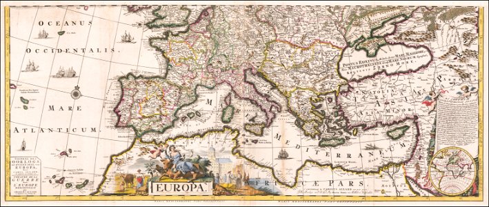
maps by carolus allard
1705 maps of europe
cornelis de jode
1579 maps
carte de la mer méditerranée en trois feuilles (dheulland et al.)
18th-century maps of the western mediterranean
carte de la mer méditerranée en trois feuilles (dheulland et al.)
18th-century maps of the eastern mediterranean
carte de la mer méditerranée en trois feuilles (dheulland et al.)
old maps of the central mediterranean
17th-century maps of the black sea
maps by willem and johannes blaeu
maps by pieter van der keere
willem barentsz
carte de la mer méditerranée en trois feuilles (dheulland et al.)
18th-century maps of the eastern mediterranean
carte de la mer méditerranée en trois feuilles (dheulland et al.)
old maps of the central mediterranean
carte de la mer méditerranée en trois feuilles (dheulland et al.)
18th-century maps of the western mediterranean
carte de la mer méditerranée en trois feuilles (dheulland et al.)
old maps of the central mediterranean
1375 maps of europe
catalan atlas
1375 maps of europe
catalan atlas
eran laor cartographic collection
gerard valck
old maps of algiers
maps by juan lopez
spanish–algerian war (1775–1785)
maps by tomas lopez
portolan charts made in the 17th century
maps by willem and johannes blaeu
bibliothèque nationale de france
maps by tomas lopez
eran laor cartographic collection
arnold colom
maps by daniel stoopendaal
biblical maps
19th-century maps of greece
pierre françois tardieu
eran laor cartographic collection
jacob peeters
françois de la pointe
maps of barbary coast
maps published by hendrik de leth
algiers in the 18th century
eran laor cartographic collection
willem blaeu
eran laor cartographic collection
willem blaeu
maps by nicolaes visscher i
maps by daniel stoopendaal
catalan atlas, 1959 reproduction
maps by john cary
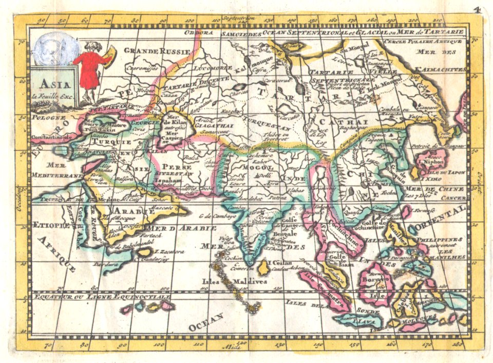
1806 maps of asia
18th-century french nautical charts
old maps of lemnos
constantinople and the scenery of the seven churches of asia minor illustrated (1836-38)
19th-century maps of the mediterranean sea
maps of barbary coast by mercator-hondius
bibliothèque nationale de france
the turkish empire in europe, asia and africa (1752)
1730s maps of the ottoman empire
historical map collection
maps by emanuel bowen
17th-century maps of the mediterranean sea
ships on maps
maps of the history of morocco
empire of morocco
17th-century maps of the mediterranean sea
maps in the library of congress
flemish prints in the british museum
coenraed lauwers
maps of barbary coast by mercator-hondius
bibliothèque nationale de france
maps of barbary coast by mercator-hondius
bibliothèque nationale de france
maps of barbary coast by mercator-hondius
bibliothèque nationale de france
1780s maps of tunisia
1780s maps of libya
maps of italy by sanson and cordier
bibliothèque nationale de france
geografia tavole moderne di geografia de la maggior parte del mondo di diversi avtori raccolte et messe secondo l'ordine di tolomeo con i disegni di molte città et fortezze di diverse provintie
maps in the library of congress
18th-century maps of the aegean sea
jean-fréderic phélypeaux
plano de la bahia de argel situada en la costa de africa - explicacion del ataque que executo en esta bahia el ex.mo señor don antonio barcelo, siendo su mayor general el capitan de navio don joseph... - btv1b53238422p
maps by tomas lopez
eran laor cartographic collection
willem albert bachiene
carte de barbarie, nigritie, guinée par guillaume delisle (1707)
1718 maps of africa
shadows of the east; or, slight sketches of scenery, persons and customs, from observations during a tour in 1853 and 1854, in egypt, palestine, syria, turkey, and greece (1855) by tobin
1855 maps of spain
maps of the islands of greece by marco boschini (1658)
bibliothèque nationale de france
maps in the rijksmuseum amsterdam
old maps of the ottoman empire
maps by daniel lizars
1820 maps of asia
shadows of the east; or, slight sketches of scenery, persons and customs, from observations during a tour in 1853 and 1854, in egypt, palestine, syria, turkey, and greece (1855) by tobin
19th-century maps of the mediterranean sea
french-language maps
1706 maps of asia
french-language maps
daniel de la feuille
kriegs theater zwischen russland und der ottomanischen pforte... - herausgegeben bey t. mollo in wien - btv1b53119380b
tranquillo mollo
map of the bosphorus strait by guillaume sanson (1665)
bibliothèque nationale de france
prints by jan luyken in the rijksmuseum amsterdam
maps in the rijksmuseum amsterdam
prints by jan luyken in the rijksmuseum amsterdam
maps in the rijksmuseum amsterdam
maps of the iberian peninsula by guillaume delisle
1700s maps of the iberian peninsula
drawings in musée carnavalet
jolly (1776-1839)
1 - 98 of 98
/ 1