Log in
All resources
Create a design
290 Free Artworks of 18th Century Maps Of France
bibliothèque nationale de france
maps of paris from bibliothèque nationale de france
turgot map of paris, bibliothèque nationale de france
atlas map
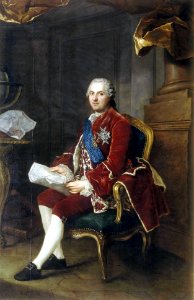
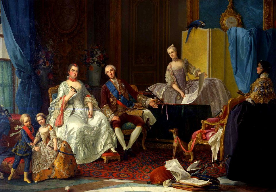
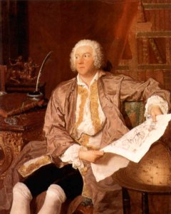
maps in portrait paintings
maps of spain by tomas lopez
oil on canvas
18th-century maps of the canary islands
sash of the order of the holy spirit in portrait paintings
portrait
paintings in the musée des arts décoratifs
paintings by pierre-antoine baudouin
anne baptiste nivelon
rococo
portrait paintings by maurice quentin de la tour (french royalty)
rococo
18th-century portrait paintings in the galleria nazionale (parma)
giuseppe baldrighi
portrait paintings by élisabeth vigée-lebrun (italian royalty)
portraits of children by élisabeth vigée-lebrun
anne baptiste nivelon
rococo
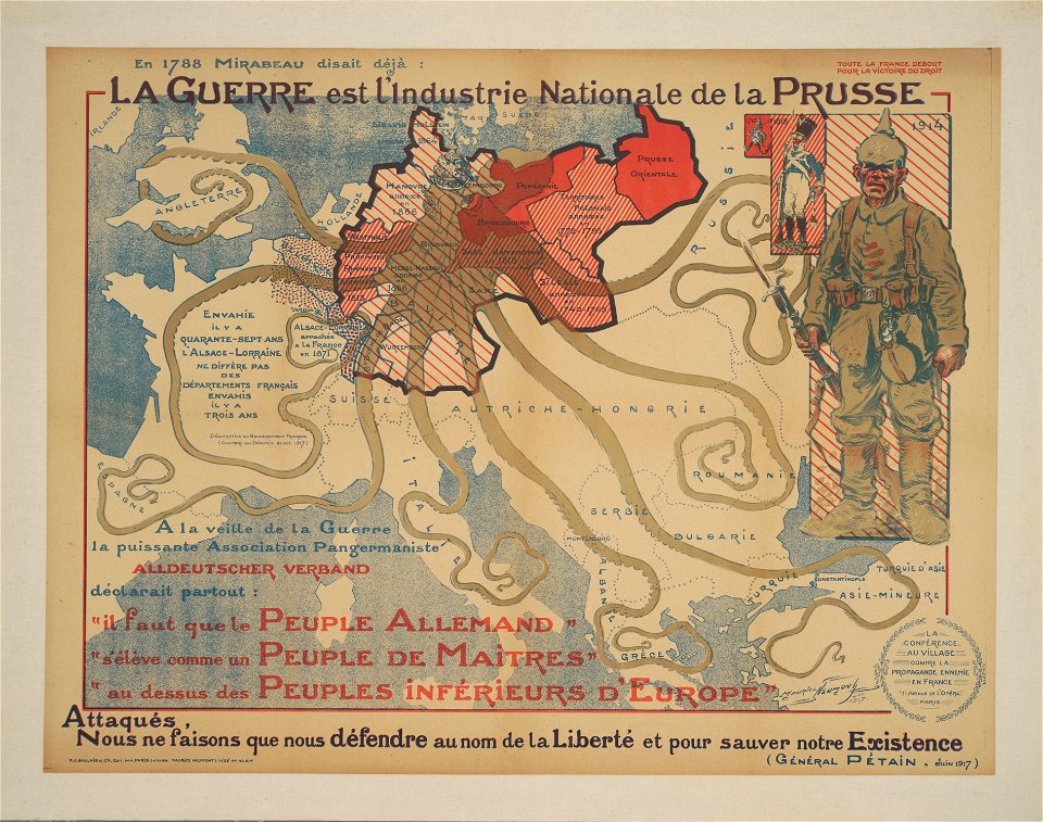
cornell: persuasive cartography: the pj mode collection
world war i anti-german propaganda
portraits of marshals of france (series commissioned by louis philippe i - versailles)
neoclassicism
anne baptiste nivelon
rococo
portrait paintings by giuseppe duprà (house of savoy)
portrait paintings of marie josephine louise of savoy
count carl gustaf tessin (nm 5535)
rococo
18th-century maps of china
18th-century maps of asia
geneviève brossard de beaulieu
jean-françois de la pérouse
jean étienne guettard
philippe buache
jean étienne guettard
philippe buache
portrait of sebastião josé de carvalho e melo, 1st marquis of pombal by louis-michel van loo and claude joseph vernet
paintings by joseph vernet
18th-century maps of the baltic sea
1770s maps of sweden
18th-century maps of north america
1708 maps of north america
1702 maps of france
1702 in guyenne
18th-century maps of the sea of marmara
18th-century maps of the dardanelles
alexis-hubert jaillot
henri sengre
historisk atlas (stockholm, norstedt & söner, 1880)
old maps of the polish-lithuanian commonwealth
maps of brest from bibliothèque nationale de france
lithographs of brest, france
old maps of the bay of gibraltar
18th-century maps of gibraltar
a set of fifty new and correct maps of england and wales
old county maps of northamptonshire
turgot map of paris, norman b. leventhal map center
sheet 19 of the turgot map of paris
old maps of the bay of gibraltar
18th-century maps of gibraltar
robert cordier (engraver)
maps by guillaume sanson
maps by john cary
1799 maps
maps by alexis-hubert jaillot
1730s maps of france
18th-century maps of the bahamas
18th-century maps of hispaniola
dessin du château de brest
old maps of brest harbours
turgot map of paris, bibliothèque nationale de france
maps of paris from bibliothèque nationale de france
turgot map of paris, bibliothèque nationale de france
maps of paris from bibliothèque nationale de france
turgot map of paris, bibliothèque nationale de france
maps of paris from bibliothèque nationale de france
turgot map of paris, bibliothèque nationale de france
maps of paris from bibliothèque nationale de france
turgot map of paris, bibliothèque nationale de france
maps of paris from bibliothèque nationale de france
turgot map of paris, bibliothèque nationale de france
maps of paris from bibliothèque nationale de france
turgot map of paris, bibliothèque nationale de france
maps of paris from bibliothèque nationale de france
turgot map of paris, bibliothèque nationale de france
maps of paris from bibliothèque nationale de france
turgot map of paris, bibliothèque nationale de france
maps of paris from bibliothèque nationale de france
turgot map of paris, bibliothèque nationale de france
maps of paris from bibliothèque nationale de france
turgot map of paris, bibliothèque nationale de france
maps of paris from bibliothèque nationale de france
turgot map of paris, bibliothèque nationale de france
maps of paris from bibliothèque nationale de france
turgot map of paris, bibliothèque nationale de france
maps of paris from bibliothèque nationale de france
turgot map of paris, bibliothèque nationale de france
maps of paris from bibliothèque nationale de france
turgot map of paris, bibliothèque nationale de france
maps of paris from bibliothèque nationale de france
turgot map of paris, bibliothèque nationale de france
maps of paris from bibliothèque nationale de france
turgot map of paris, bibliothèque nationale de france
maps of paris from bibliothèque nationale de france
turgot map of paris, bibliothèque nationale de france
maps of paris from bibliothèque nationale de france
turgot map of paris, bibliothèque nationale de france
maps of paris from bibliothèque nationale de france
turgot map of paris, bibliothèque nationale de france
maps of paris from bibliothèque nationale de france
old maps of vermandois
maps of somme river
maps of paris from bibliothèque nationale de france
proletarian literature
old maps of île-de-france
1785 maps of france
18th-century maps of the black sea
maps by louis brion de la tour
atlas géographique des quatre parties du monde (delisle)
18th-century maps of the iberian peninsula
antoine-françois tardieu
maps from gallica
maps by nicolas sanson
1730s maps of france
maps in the british museum
1780s maps of france
antoine-françois tardieu
maps from gallica
atlas geographico del reyno de españa e islas adjacentes (1757)
1757 maps of spain
18th-century maps of japan
works after jan goeree
18th-century maps of the canary islands
maps of spain by tomas lopez
old maps of the bay of gibraltar
carolus allard
old maps of the strait of gibraltar
1762 maps of spain
old maps of bouvet island
bouvet island
a new & correct map of england and wales (foster)
1750s maps of england
18th-century maps of veneto
1700s maps of slovenia
châlons-en-champagne in the 17th century
hugues picart
old county maps of hertfordshire
maps by thomas kitchin
old maps of the republic of genoa
maps of the duchy of milan
old maps of french guiana
old maps of venezuela
maps by herman moll
john perry
maps by pieter mortier
maps from gallica
18th-century maps of barbados
1780 maps of the caribbean
french-language maps of asia
1750s maps of asia
1782 maps of the caribbean
maps by juan lopez
maps of spain by tomas lopez
1761 maps of spain
maps of spain by tomas lopez
1780 maps of spain
1780s maps of portugal
maps by tomas lopez
18th-century maps of the azores
1780s maps of portugal
maps of spain by tomas lopez
1779 maps of spain
maps of spain by tomas lopez
old maps of lanzarote
18th-century maps of the canary islands
maps of spain by tomas lopez
1770s maps of the world
maps by tomas lopez
18th-century maps of the canary islands
maps of spain by tomas lopez
1700s maps of the tsardom of russia
1700s maps of eastern europe
18th-century maps of portugal
maps by carolus allard
maps of spain by tomas lopez
1780 maps of spain
18th-century maps of the philippines
baroque painting
1780s maps of the caribbean
maps by juan lopez
maps by tomas lopez
1785 maps
18th-century maps of veneto
1700s maps of slovenia
maps of cagliari by braun & hogenberg
maps of valletta by braun & hogenberg
18th-century maps of bretagne
robert cordier (engraver)
18th-century maps of the atlantic ocean
maps by emanuel bowen
cornelis huyberts
guillaume sanson
mapa del principado de cataluña (1776)
18th-century maps of catalonia
maps by nicolas sanson
maps from gallica
1 - 100 of 290
Next page
/ 3