Log in
All resources
Create a design
299 Free Artworks of 1880 Maps
historisk atlas (stockholm, norstedt & söner, 1880)
guides joanne
maps in the library of congress
maps of paris from paris musées
maps of paris by paul dujardin
atlas des anciens plans de paris by imprimerie nationale, 1880 from the musée carnavalet
musée carnavalet
algeria in the 1880s
bibliothèque nationale de france
old maps of algeria
media from stadsarchief rotterdam
baroque
sugawara michizane
ukiyo-e
caricatures
cartoons
media from stadsarchief rotterdam
baroque
media from the national library of finland
classicism
historisk atlas (stockholm, norstedt & söner, 1880)
maps of the history of scandinavia
old maps of the kingdom of france (987-1792)
19th-century maps of the british isles
maps of the history of the middle east
maps of 12th-century asia
southwark, philadelphia
sparks shot tower
lithographs of paris
floor plans of paris
eric (xii) of sweden (erik magnusson)
maps of the history of sweden
michael andreas barclay de tolly
mikhail kutuzov in portraits
maps of the history of denmark
old maps of scandinavia
historisk atlas (stockholm, norstedt & söner, 1880)
old maps of the polish-lithuanian commonwealth
bird's eye view of knoxville, tennessee, 1886
maps in the library of congress
maps of the history of palestine
1880s maps of palestine
maps in the library of congress
old maps of anniston, alabama
maps of the history of sweden
1386 in sweden
maps showing history of the early middle ages
charles the bald
maps in the library of congress
bird's eye view maps of alabama
historisk atlas (stockholm, norstedt & söner, 1880)
maps showing 843
maps of the umayyad caliphate (damascus)
old maps of the caliphate
historisk atlas (stockholm, norstedt & söner, 1880)
19th-century maps of the british isles
maps of the history of sweden
maps of the kalmar union
maps of paris from bibliothèque nationale de france
old maps of the paris metro
historisk atlas (stockholm, norstedt & söner, 1880)
maps showing 5th-century bc history
kobe foreign settlement
old maps of kobe
historisk atlas (stockholm, norstedt & söner, 1880)
old maps of the polish-lithuanian commonwealth
historisk atlas (stockholm, norstedt & söner, 1880)
old maps of the carolingian empire
gewerbe-ausstellung für rheinland, westfalen und benachbarte bezirke
old maps of düsseldorf
lithographs of paris
floor plans of paris
historisk atlas (stockholm, norstedt & söner, 1880)
maps of 14th-century europe
maps from the earth and its inhabitants, vol. x
zagazig
19th-century maps of cairo
1888 in egypt
maps of 12th-century asia
maps of the crusades
historisk atlas (stockholm, norstedt & söner, 1880)
maps of 13th-century greece
maps from the mechanical curator collection
german renaissance
abdur rahman khan in art
thomas dewell scott
historisk atlas (stockholm, norstedt & söner, 1880)
maps of 13th-century germany
historisk atlas (stockholm, norstedt & söner, 1880)
old maps of the polish-lithuanian commonwealth
1880s maps of tunisia
tunisia in the 1880s
maps in the library of congress
1880 maps
maps of the history of sweden
old maps of scandinavia
1880s maps of tunisia
tunisia in the 1880s
1880s maps of tunisia
tunisia in the 1880s
historisk atlas (stockholm, norstedt & söner, 1880)
maps of the history of asia
bird's eye view maps of illinois
maps in the library of congress
algeria in the 1880s
old maps of algeria
algeria in the 1880s
old maps of algeria
19th-century maps of chechnya
1880s maps of the caucasus
maps of luzy (nièvre)
amédée jullien
montgomery, alabama in the 1880s
maps in the library of congress
historisk atlas (stockholm, norstedt & söner, 1880)
maps of 11th-century italy
1880s maps of the netherlands
1880s maps of belgium
old maps of algiers
maps from gallica
maps in the library of congress
old maps of anniston, alabama
maps from the earth and its inhabitants, vol. iv
bathymetric maps of the united kingdom
turgot map of paris, musée carnavalet
maps of paris from paris musées
turgot map of paris, musée carnavalet
maps of paris from paris musées
turgot map of paris, musée carnavalet
maps of paris from paris musées
turgot map of paris, musée carnavalet
maps of paris from paris musées
algeria in the 1880s
old maps of oran
maps from the earth and its inhabitants, vol. iv
geological maps of the united kingdom
maps by jan eduard wagner
františek kytka
19th-century maps of bohemia
1880s maps of czechia
maps from gallica
old maps of genoa
maps in the library of congress
1880s maps of new hampshire
algeria in the 1880s
old maps of algeria
dr. wilh. junker's reisen in afrika 1875-1886
1880s maps of sudan
admiralty charts region b: england wales ireland english channel southern north sea
admiralty charts 1401-1600
maps from the earth and its inhabitants, vol. x
19th-century maps of cairo
algeria in the 1880s
old maps of algeria
maps of paris from paris musées
plan de turgot
maps from the earth and its inhabitants, vol. iv
1880s maps of england
maps, prints and photographs in royal danish library
casinoteatret
rudolf leuzinger
maps of france
maps from the earth and its inhabitants, vol. v
maps of skaftafell
atlas des anciens plans de paris by imprimerie nationale, 1880 from the musée carnavalet
maps of paris from paris musées
baumwollspinnerei im sood
fabrikkanal sihltal
maps from the earth and its inhabitants, vol. x
1880s maps of egypt
the story of mexico (1889 book)
1880s maps of mexico
1880s maps of tunisia
maps from gallica
with the armies of the balkans and at gallipoli (1880)
battle of gallipoli
drawings in the stadsarchief amsterdam
johan martinus anthon rieke
the cruise of the marchesa (1889)
1880s maps of the philippines
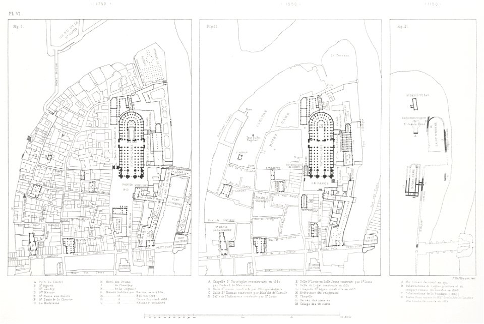
atlas des anciens plans de paris by imprimerie nationale, 1880 from the musée carnavalet
maps of paris from paris musées
maps in the library of congress
1882 maps of new york (state)
maps from the earth and its inhabitants, vol. iv
1880s maps of ireland
lithographs of paris
floor plans of paris
algiers in the 1880s
old maps of algiers
maps from the earth and its inhabitants, vol. iv
turlough
historisk atlas (stockholm, norstedt & söner, 1880)
old maps of the roman empire
maps of paris from paris musées
baroque
maps from the earth and its inhabitants, vol. iv
kingsmead, bath
maps from the earth and its inhabitants, vol. iii
old maps of bonn
maps from the earth and its inhabitants, vol. xi
africa in the 1880s
maps from the earth and its inhabitants, vol. xi
africa in the 1880s
maps from the earth and its inhabitants, vol. xi
africa in the 1880s
algeria in the 1880s
old maps of algeria
algeria in the 1880s
old maps of algeria
1 - 100 of 299
Next page
/ 3