Map of the Notre-Dame district, Theodor Josef Hubert Hoffbauer, between 1875 and 1882

Map of the Notre-Dame district, Theodor Josef Hubert Hoffbauer, between 1875 and 1882

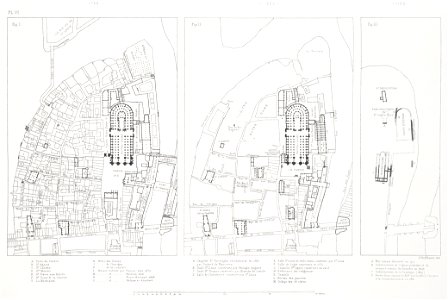
Aerial plans of the area around notre-dame cathedral. Three maps, in order from left to right, show the area in 1750, 1550, and 1150. On the overlay, the same area is shown in 1881. Date: between 1875 and 1882. Dimensions: 24 x 30 cm. Medium: lithograph. Collection: Brown University Library. Plan du quartier de Notre-Dame 1150, 1550, 1750
Edit image
Published by:
Creazilla
Author: Theodor Josef Hubert Hoffbauer (1839–1922)Source: commons.wikimedia.org

Loading...

1 download
Loading...
lithographs of parisfloor plans of parismaps of history of streets of parisparis à travers les âgesfloor plans of cathédrale notre-dame de parispalais épiscopal de parispalais de l'archevêché de parisold maps of île de la citéparis in the 12th centuryparis in the 16th centurymaps of paris in the 1750snotre-dame de paris on the mapsnotre-dame de paris in the 1880séglise saint-denis-du-paslithographbrown university librarytheodor josef hubert hoffbauer

MORE LIKE THIS

Creazilla logo
Over 10 million free graphic resources for content creators and designers.
© 2018 - 2025 Creazilla
Our resourcesAll imagesPhotosDigital illustrationsClipartIconsPNG ImagesEmojisSilhouettesTraditional Art3D ModelsVectorsFontsColor namesColor palettesGradientsAudioAnimationVideosTemplates
InformationAbout CreazillaTerms of useTech teamPrivacy policyLicence Information
FeedbackContact Us