Log in
All resources
Create a design
2,204 Free Images of Ocean
bibliothèque nationale de france
considérations géographiques et physiques sur les nouvelles découvertes au nord de la grande mer
cooper hewitt, smithsonian design museum
jean-jérôme baugean
hudson river school
voyage pittoresque autour du monde (1822) by louis choris
louis choris
paper
oil on canvas
arnold van langren map of southwest africa
voyage pittoresque autour du monde (1822) by louis choris
louis choris
voyage pittoresque autour du monde (1822) by louis choris
louis choris
voyage pittoresque autour du monde (1822) by louis choris
louis choris
voyage pittoresque autour du monde (1822) by louis choris
louis choris
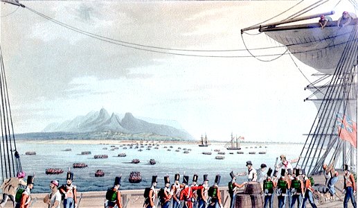
eight views of the mauritius comprising the positions of the british army, 1810
prints in the national maritime museum, london
karl schmidt-rottluff's collection of objects from colonial contexts in the brücke-museum berlin
expressionism,impressionism
karl schmidt-rottluff's collection of objects from colonial contexts in the brücke-museum berlin
expressionism,impressionism
maps by willem and johannes blaeu
laurens reael
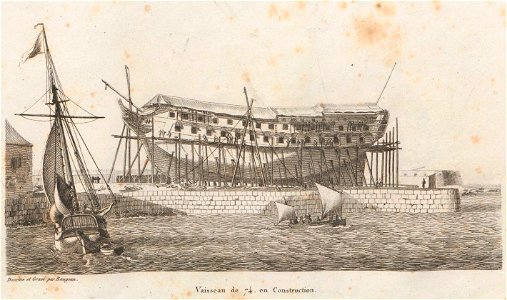
seventy-fours (ships)
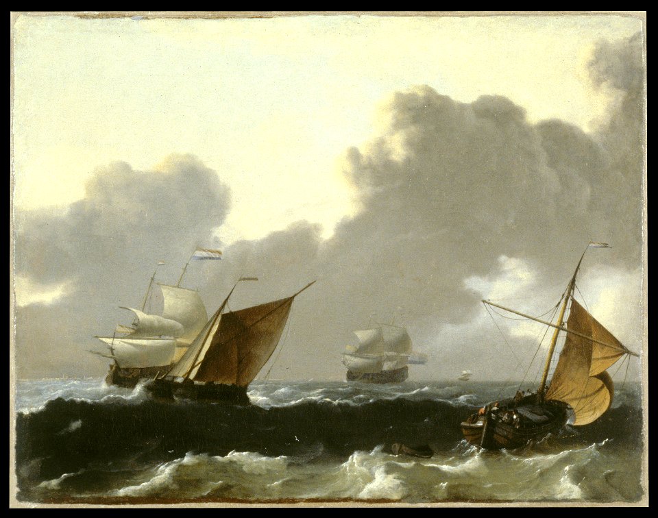
jean-jérôme baugean
history of the french navy
jean-jérôme baugean
cassier's magazine, 1895
north west (ship, 1894)
watercolor paintings by deborah griscom passmore
usda pomological watercolors of grapes
considérations géographiques et physiques sur les nouvelles découvertes au nord de la grande mer
hokkaido in art
maps from university of amsterdam special collections
atlas der neederlanden
william elliott (lieutenant)
hms ruby (ship, 1776)
newspapers of the united states, 1900
cartoonists from the united states
everett d. graff collection of western americana
st. louis, missouri in the 1800s
paul-adolphe kauffmann
1900 posters
maps in the british museum
1780s maps of france
national archives at college park - still pictures
uss monitor (ship, 1862)
maps of the arctic ocean
maps of the north pole
prints, drawings and watercolours of the royal museums greenwich
1834 in art
paintings of seascapes by william trost richards
hudson river school
the pacific tourist (1877)
hudson river school
arnold van langren map of east africa
1600 maps of africa
maps of hormuz by braun & hogenberg
hebrew university of jerusalem
pedro álvares cabral disembarking in porto seguro in 1500 by oscar pereira da silva (museu histórico nacional)
breaking ocean waves in brazil
the pacific tourist (1877)
hudson river school
paintings by ernest longfellow in longfellow national historic site
landscapes of massachusetts
20th-century sailing ships in paintings
thomas somerscales
maps by willem and johannes blaeu
1638 maps of asia
paintings by amadeo de souza-cardoso in the calouste gulbenkian museum
modernism,impressionism,expressionism,cubism,futurism,postmodernism
1520s maps of the world
propaganda map
ship covers of the soviet union
romanticism
considérations géographiques et physiques sur les nouvelles découvertes au nord de la grande mer
isla de los estados
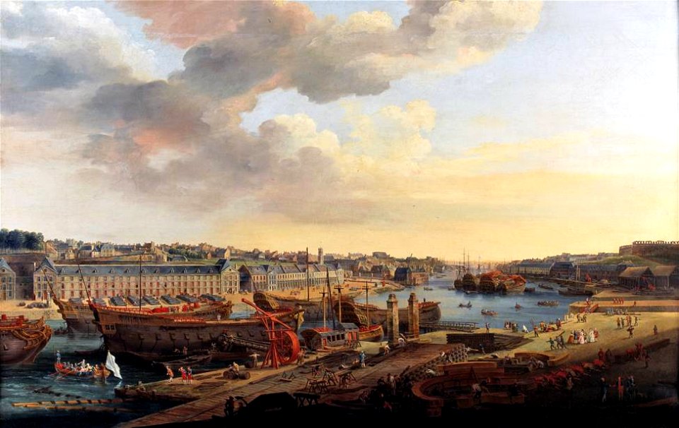
vue du port de brest prise depuis la terrasse des capucins, 1774, louis-nicolas van blarenberghe
french ship sphinx (1776)
the atlantic islands as resorts of health and pleasure (1878)
1870s maps of the atlantic ocean
arnold van langren map of southwest africa
bibliothèque nationale de france
arnold van langren map of east africa
bibliothèque nationale de france
jean-jérôme baugean
barques
john ross (1777-1856)
northwest passage
carlos i of portugal on stamps
1892 stamps of funchal
drawings in the cooper–hewitt, smithsonian design museum
hudson river school
vehicles in auckland
ocean liners
historical images of corsica
jean-jérôme baugean
old maps of bouvet island
bouvet island
walla walla (ship, 1881)
t.j. potter (ship, 1888)
animals
fish
united states navy images from north carolina
recovery of uss monitor parts
james cameron
don walsh
baroque paintings in the walters art museum
marine paintings by ludolf bakhuizen
prints in the cooper–hewitt, smithsonian design museum
realism
paintings of bear hunting
julius von payer
a system of modern geography (1810)
1810s maps of the pacific ocean
raphus cucullatus (illustrations)
extinct birds (rothschild book)
maps from the earth and its inhabitants, vol. iv
1880s maps of the atlantic ocean
harper's weekly illustrations by thomas nast
george m. robeson
considérations géographiques et physiques sur les nouvelles découvertes au nord de la grande mer
old maps of the yellow sea
considérations géographiques et physiques sur les nouvelles découvertes au nord de la grande mer
isla de los estados
considérations géographiques et physiques sur les nouvelles découvertes au nord de la grande mer
eso island
considérations géographiques et physiques sur les nouvelles découvertes au nord de la grande mer
eso island
arnold van langren map of southwest africa
renaissance
arnold van langren map of southwest africa
1596 maps of africa
jean-jérôme baugean
adriatic sea
collectie archief van architectenbureau baanders
photographs in the stadsarchief amsterdam
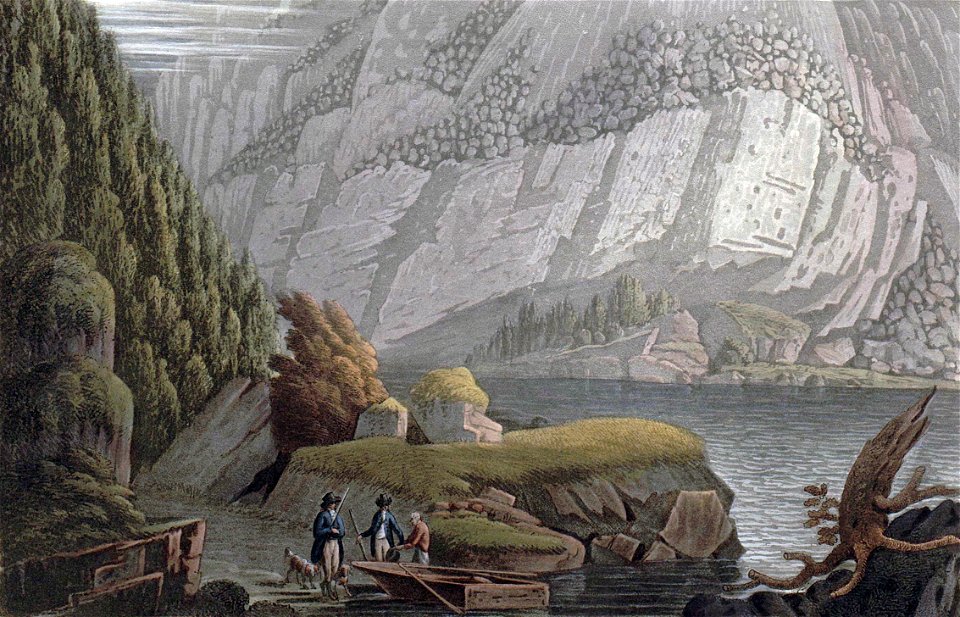
boydell's picturesque scenery of norway
kristiansand in art
drawings by winslow homer in the cooper–hewitt, smithsonian design museum
realism
maps from university of amsterdam special collections
atlas der neederlanden
united states navy images from north carolina
recovery of uss monitor parts
b. sprengel & co.
willy stöwer
physical geography (1899) by davis
monsoon maps of india
carlos i of portugal on stamps
1893 stamps of funchal
maps from university of amsterdam special collections
atlas der neederlanden
bibliothèque nationale de france
georg keller
coloured lithographs in the british museum
pieter willem marinus trap
maps by willem and johannes blaeu
17th-century maps of bermuda
nypl american popular songs
volcanoes in art
thomas wright (engraver)
francisco xavier mina
19th-century maps of the indian ocean
physical geography (1899) by davis
19th-century maps of the indian ocean
physical geography (1899) by davis
physical geography (1899) by davis
maps of ocean currents
victor levasseur - maps of the world
old maps of north america
victor levasseur - maps of the world
1850s maps of oceania
surfing
ocean
1750s maps of california
philippe buache
arnold van langren map of southwest africa
renaissance
19th-century maps of the malay archipelago
the cruise of the marchesa (1889)
drawings in the cooper–hewitt, smithsonian design museum
hudson river school
1727 maps of africa
1720s maps of egypt
1727 maps of africa
1720s maps of egypt
united states navy images from north carolina
recovery of uss monitor parts
maps by gouverneur k. warren
maps by edwin freyhold
drawings by winslow homer in the cooper–hewitt, smithsonian design museum
realism
drawings by winslow homer in the cooper–hewitt, smithsonian design museum
realism
maps by pieter mortier
maps from gallica
hendrik van langren map of south asia
1595 maps of asia
lilacs in art
seas in art
maps by macdonald gill
royal mail
maps of the arctic ocean
atlas novus (blaeu)
vehicle
travel
1601 - 1700 of 2,204
Next page
/ 23