Log in
All resources
Create a design
7,306 Free Images of Geography
maps from the earth and its inhabitants, vol. iv
geography of africa
africa in the 1890s
engravings from la france illustrée
the earth and its inhabitants, vol. xii: africa, vol. iii
1880s maps of the british isles
bologna ptolemy
latin-language maps
the earth and its inhabitants, vol. xiii: africa, vol. iv
1477 maps
the earth and its inhabitants, vol. xiii: africa, vol. iv
geography of africa
the earth and its inhabitants, vol. xiii: africa, vol. iv
africa in the 1890s
the earth and its inhabitants, vol. x: africa, vol. i
geography of africa
the earth and its inhabitants, vol. xiii: africa, vol. iv
geography of africa
the earth and its inhabitants, vol. xii: africa, vol. iii
africa in the 1890s
the earth and its inhabitants, vol. xii: africa, vol. iii
africa in the 1890s
the earth and its inhabitants, vol. xii: africa, vol. iii
africa in the 1890s
the earth and its inhabitants, vol. xii: africa, vol. iii
africa in the 1890s
the earth and its inhabitants, vol. xii: africa, vol. iii
africa in the 1890s
the earth and its inhabitants, vol. xiii: africa, vol. iv
africa in the 1890s
the earth and its inhabitants, vol. xii: africa, vol. iii
africa in the 1890s
the earth and its inhabitants, vol. xii: africa, vol. iii
africa in the 1890s
the earth and its inhabitants, vol. xii: africa, vol. iii
africa in the 1890s
the earth and its inhabitants, vol. xii: africa, vol. iii
africa in the 1890s
the earth and its inhabitants, vol. xiii: africa, vol. iv
geography of africa
the earth and its inhabitants, vol. xii: africa, vol. iii
africa in the 1890s
the earth and its inhabitants, vol. xi: africa, vol. ii
africa in the 1880s
maps from the earth and its inhabitants, vol. xi
1800s maps of algeria
the earth and its inhabitants, vol. xi: africa, vol. ii
africa in the 1890s
the earth and its inhabitants, vol. xii: africa, vol. iii
africa in the 1890s
the earth and its inhabitants, vol. xi: africa, vol. ii
africa in the 1890s
the earth and its inhabitants, vol. xiii: africa, vol. iv
africa in the 1890s
the earth and its inhabitants, vol. xii: africa, vol. iii
africa in the 1890s
ptolemy's 7th asian map
bologna ptolemy
ptolemy's 2nd asian map
bologna ptolemy
latin-language maps
bologna ptolemy
ptolemy's 3rd european map
bologna ptolemy
eran laor cartographic collection
raymond bonheur
engravings from la france illustrée
historical images of saint-étienne
engravings from la france illustrée
buildings in rethel
the history of barbados; comprising a geographical and statistical description of the island (1848) by robert h. schombourgk
old maps of barbados
engravings from la france illustrée
cère
engravings from la france illustrée
salers
engravings from la france illustrée
queyras
engravings from la france illustrée
meyras
engravings from la france illustrée
engravings from la france illustrée
nature in embrun
historical images of brive-la-gaillarde
engravings from la france illustrée
engravings from la france illustrée
views of givet
engravings from la france illustrée
château de murat (allier)
bibliothèque nationale de france
raymond bonheur
latin-language maps
bologna ptolemy
1470s maps of the world
latin-language maps
engravings from la france illustrée
views of marseille
engravings from la france illustrée
buildings in sedan
engravings from la france illustrée
historical images of calvados
geography of gößweinstein
ernst kiesling
views in the mysore country (1794)
sir alexander allan, 1st baronet
drawings in the yale center for british art
orientalism
william smith (lexicographer)
maps of nineveh
the earth and its inhabitants, vol. xi: africa, vol. ii
africa in the 1890s
the earth and its inhabitants, vol. xi: africa, vol. ii
africa in the 1890s
green river (colorado river) - historical images
geography of daggett county, utah
charles eugène perron
old maps of trabzon
maps from the earth and its inhabitants, vol. xii
africa in the 1890s
maps from the earth and its inhabitants, vol. xii
africa in the 1890s
maps from the earth and its inhabitants, vol. xi
africa in the 1890s
geography of colorado springs, colorado
postcards of colorado springs, colorado
maps from the earth and its inhabitants, vol. iv
1880s maps of the british isles
maps from the earth and its inhabitants, vol. iv
maps of the firth of clyde
maps from the earth and its inhabitants, vol. iv
19th-century maps of county durham
maps from the earth and its inhabitants, vol. iv
19th-century maps of the isle of man
maps from the earth and its inhabitants, vol. iv
maps of ben nevis
maps from the earth and its inhabitants, vol. iv
1880s maps of the british isles
maps from the earth and its inhabitants, vol. iv
1880s maps of ireland
maps from the earth and its inhabitants, vol. iv
19th-century maps of kent
james smithson as an oxford student (james roberts - national portrait gallery, washington)
the americana - a universal reference library (1908)
maps from the earth and its inhabitants, vol. iv
old maps of the firth of forth
maps from the earth and its inhabitants, vol. iv
old maps of liverpool
maps from the earth and its inhabitants, vol. iv
1880s maps of scotland
maps from the earth and its inhabitants, vol. iv
old maps of the hebrides
maps from the earth and its inhabitants, vol. iv
1880s maps of the british isles
maps from the earth and its inhabitants, vol. iv
old maps of hartlepool
maps from the earth and its inhabitants, vol. iv
19th-century maps of lincolnshire
maps from the earth and its inhabitants, vol. iv
1880s maps of the british isles
maps from the earth and its inhabitants, vol. iv
old maps of derby
the americana - a universal reference library (1908)
romanticism
maps from the earth and its inhabitants, vol. iv
old maps of hadrian's wall
maps from the earth and its inhabitants, vol. iv
old maps of glasgow
maps from the earth and its inhabitants, vol. iv
1880s maps of the british isles
maps from the earth and its inhabitants, vol. iv
1880s maps of the british isles
maps from the earth and its inhabitants, vol. iv
19th-century maps of lancashire
maps from the earth and its inhabitants, vol. iv
old maps of leeds
maps from the earth and its inhabitants, vol. iv
old maps of york
maps from the earth and its inhabitants, vol. iv
1880s maps of the british isles
maps from the earth and its inhabitants, vol. iv
maps of loch lomond
maps from the earth and its inhabitants, vol. iv
1880s maps of the british isles
maps from the earth and its inhabitants, vol. iv
old maps of sheffield
maps from the earth and its inhabitants, vol. iv
19th-century maps of lancashire
maps from the earth and its inhabitants, vol. iv
1880s maps of the british isles
maps from the earth and its inhabitants, vol. iv
old maps of the isle of arran
maps from the earth and its inhabitants, vol. iv
1880s maps of the british isles
ptolemy's 8th european map
bologna ptolemy
latin-language maps
bologna ptolemy
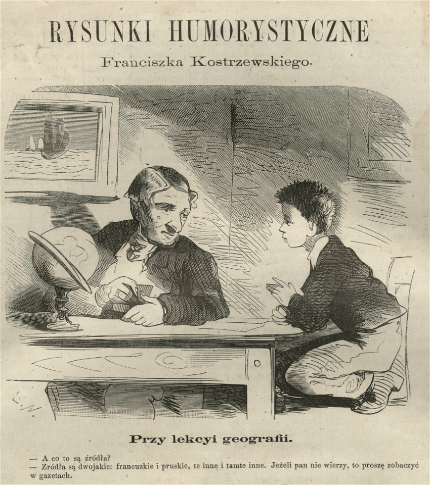
franciszek kostrzewski
woodcut print
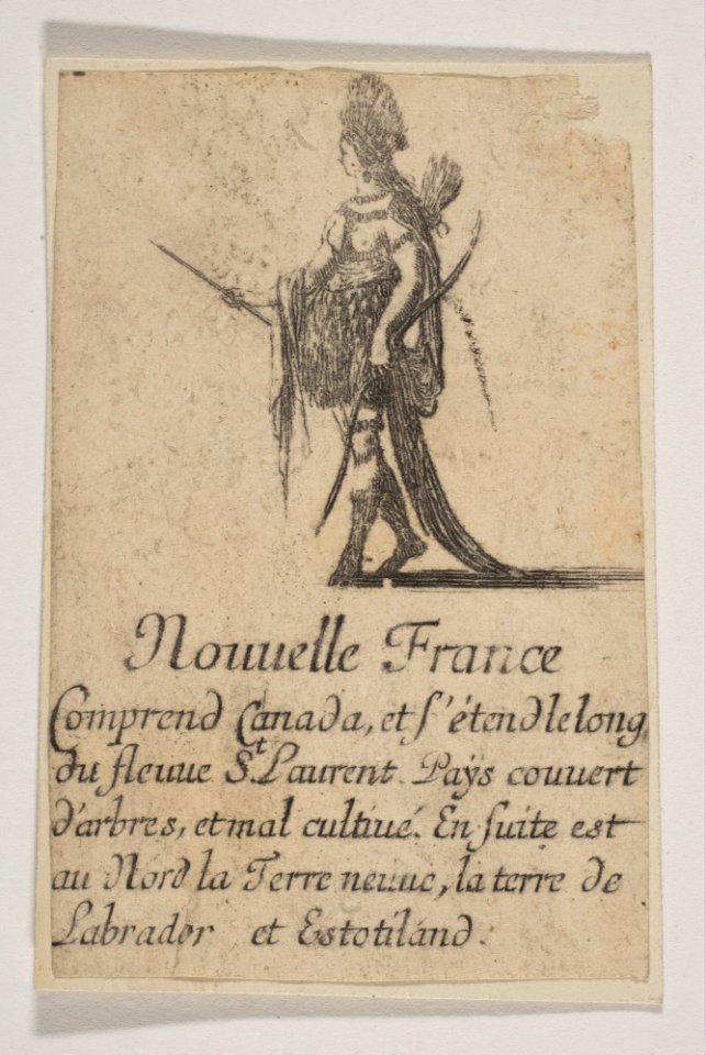
jeu de la géographie (1644)
baroque
books by edward wright
1610 books from london
façade occidentale de la cathédrale saint-étienne de bourges
engravings from la france illustrée
boydell's picturesque scenery of norway (ng.k&h.1979.0056)
svinesund
boydell's picturesque scenery of norway (ng.k&h.1979.0056)
svinesund
4401 - 4500 of 7,306
Next page
/ 74