Log in
All resources
Create a design
26,489 Free Artworks of Map
bibliothèque nationale de france
maps by willem and johannes blaeu
africa in the 1890s
maps from the earth and its inhabitants, vol. xiii
maps of africa
maps from the earth and its inhabitants, vol. ix
guillaume sanson
maps from the earth and its inhabitants, vol. xi
maps from valentine's manual
george hayward
maps of the course of the rhine by guillaume sanson
bibliothèque nationale de france
maps from the earth and its inhabitants, vol. xi
1800s maps of algeria
maps from valentine's manual
george hayward
maps from the earth and its inhabitants, vol. xiii
africa in the 1890s
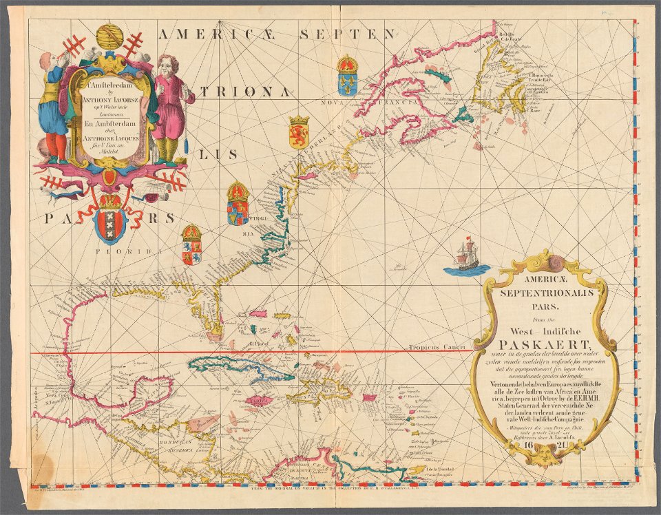
1620s maps of north america
1620s maps of the caribbean
1620s maps of north america
1620s maps of the caribbean
maps from university of amsterdam special collections
atlas der neederlanden
maps from university of amsterdam special collections
atlas der neederlanden
dr. wilh. junker's reisen in afrika 1875-1886
1880s maps of sudan
maps from university of amsterdam special collections
atlas der neederlanden
everett d. graff collection of western americana
maps of the nez perce war
french-language maps
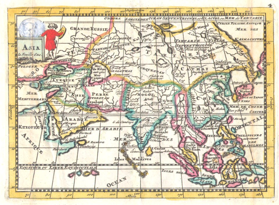
1706 maps of asia
maps from the earth and its inhabitants, vol. xiii
maps of telegraph lines
maps from the earth and its inhabitants, vol. xvi
1870s maps of panama
maps from the earth and its inhabitants, vol. iii
linguistic maps of the balkans
maps from the earth and its inhabitants, vol. vii
maps of the mongol empire
maps from the earth and its inhabitants, vol. vi
maps of weather and climate of asia
maps from the earth and its inhabitants, vol. ix
maps indicating exploration
maps from the earth and its inhabitants, vol. v
1870s maps of russia
maps from the earth and its inhabitants, vol. ix
1870s maps of jerusalem
maps from the earth and its inhabitants, vol. xiii
maps indicating exploration
maps from the earth and its inhabitants, vol. viii
1870s maps of india
maps from the earth and its inhabitants, vol. v
1870s maps of norway
maps from the earth and its inhabitants, vol. iii
1870s maps of belgium
maps from the earth and its inhabitants, vol. xvi
1870s maps of panama
maps from the earth and its inhabitants, vol. vii
1878 maps of asia
maps from the earth and its inhabitants, vol. xi
1870s maps of tunisia
maps from the earth and its inhabitants, vol. vi
maps of the history of russia
maps from the earth and its inhabitants, vol. ix
1870s maps of jerusalem
maps from the earth and its inhabitants, vol. viii
1870s maps of india
1740s maps of portugal
daniel de la feuille
map of the german empire by louis stanislas d'arcy de la rochette
1780s maps of lithuania
drawings in the museu antônio parreiras
graphite
old maps of swabia
maps by john cary
kobe foreign settlement
old maps of kobe
maps made in the 17th century
penisola balcanica
maps by willem and johannes blaeu
1630s maps of the caucasus
magni ducatus lithuaniae
1640s maps of lithuania
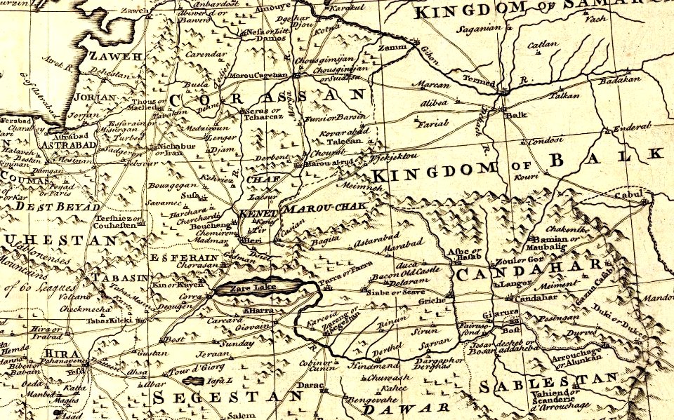
1747 persia map by emanuel bowen
details of old maps
general atlas (1773)
old maps of sakhalin
maps by emanuel bowen
britannia depicta
old maps of geraardsbergen
1649 in europe
turgot map of paris – derivative files
bastille
maps by edward wright
molyneux globes
19th-century maps of europe
maps by john cary
19th-century maps of europe
maps by john cary
miniature speed atlas (1627) pieter van den keere
old maps of the orkney islands
maps in the library of congress
old maps of antigua and barbuda
maps of the west-indische compagnie
1665
maps of paris from the david rumsey historical map collection
maps of île-de-france by françois de la guillotière
maps by jodocus hondius
copper engravings
curt teich postcard archives
postcards of arizona
dexter press postcards of arizona
curt teich postcard archives
maps from the earth and its inhabitants, vol. xi
africa in the 1890s
images of places from encyclopædia britannica
old maps of edinburgh
1580s maps of the netherlands
1580s maps of belgium
topographia alsatiae (merian)
baroque
map of ghent by pierre husson
satellite pictures of the eastern hemisphere
fra mauro map derivative works
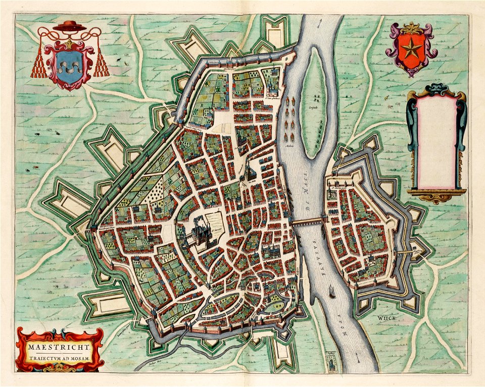
map of maastricht by willem and johannes blaeu (1649)
coats of arms of maastricht
maps of wales by humphrey llwyd
maps by pieter van der keere
media from regionaal archief alkmaar
maps of wieringen
1880s maps of tunisia
tunisia in the 1880s
maps by willem and johannes blaeu
1651 in germany
1880s maps of tunisia
tunisia in the 1880s
china veteribus sinarum regio nunc incolis tame dicta
old maps of china in harvard map collection
1841 maps of the united states
maps by george w. boynton
1771 maps of south america
andrew dury
atlas maior, vol 2 (sweden, russia, poland, eastern europe, and greece) - joan blaeu, 1667 - bl 114.h(star).2
1667 maps of russia
maps of constantinople by braun & hogenberg
eran laor cartographic collection
maps of bratislava by braun & hogenberg
eran laor cartographic collection
illustrations from the sea serpent by george roux
1900s maps of japan
charles eugène perron
old maps of trabzon
itinerario (jan huygen van linschoten)
renaissance
maps from the earth and its inhabitants, vol. xii
africa in the 1890s
maps from the earth and its inhabitants, vol. xiii
maps of africa
maps from the earth and its inhabitants, vol. xii
africa in the 1890s
map of bruges by marcus gheeraerts (i)
drawings in the groeningemuseum
map of bruges by marcus gheeraerts (i)
drawings in the groeningemuseum
old maps of trinidad and tobago
17th-century maps of venezuela
18th-century maps of barbados
1780 maps of the caribbean
maps of spain by tomas lopez
1770 maps of spain
17th-century maps of slovenia
1635 maps
1572 in london
1572 maps
17th-century maps of slovenia
1635 maps
maps by nicolas sanson
guillaume sanson
maps by matthäus merian
baroque
1830 maps of the united states
maps by george w. boynton
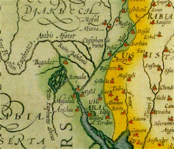
maps of persia by mercator-hondius
details of old maps
1780s maps of the balkans
maps by tomas lopez
maps of alsace by guillaume sanson
1660s maps of alsace
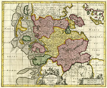
17th-century maps of schleswig-holstein
maps by pieter schenk (i)
old maps of ghent by jacques horenbault
old maps of coupure (ghent)
maps of paris from bibliothèque nationale de france
dheulland map of paris
maps by willem and johannes blaeu
old maps of alexandria
victor levasseur - maps of the world
1854 maps of africa
maps of groningen by braun & hogenberg
martinikerk (groningen)
maps of the land of valkenburg
guillaume sanson
maps by alexis-hubert jaillot
maps by nicolas sanson
maps of the land of valkenburg
guillaume sanson
3601 - 3700 of 26,489
Next page
/ 265