Log in
All resources
Create a design
26,489 Free Artworks of Map
arnold's geographical handbook (1899)
maps in the library of congress
bibliothèque nationale de france
hishikawa school,ukiyo-e
tōkaidō bunkenzu - 1-bu o motte 1-chō ni ateru
1899 maps of the united kingdom
1899 maps of south america
1899 maps of africa
1890s maps of scotland
1899 maps of europe
arnold's geographical handbook (1899)
old maps of lanarkshire
arnold's geographical handbook (1899)
1899 maps of the caribbean
arnold's geographical handbook (1899)
1899 maps of italy
arnold's geographical handbook (1899)
1899 maps of the world
arnold's geographical handbook (1899)
1890s maps of south africa
arnold's geographical handbook (1899)
1899 maps of south america
arnold's geographical handbook (1899)
1890s maps of oceania
arnold's geographical handbook (1899)
1899 maps of the united kingdom
arnold's geographical handbook (1899)
1890s maps of scotland
arnold's geographical handbook (1899)
1899 maps of south america
a school geography (1898) by bird
old maps of hong kong
arnold's geographical handbook (1899)
1899 maps of the caribbean
arnold's geographical handbook (1899)
1899 maps of the caribbean
arnold's geographical handbook (1899)
1899 maps of the united states
arnold's geographical handbook (1899)
1899 maps of the united kingdom
ghosts & ghoulish scenes
arnold's geographical handbook (1899)
1899 maps of the united kingdom
arnold's geographical handbook (1899)
1899 maps of the united states
arnold's geographical handbook (1899)
1899 maps of europe
arnold's geographical handbook (1899)
1899 maps of russia
arnold's geographical handbook (1899)
1890s maps of ireland
arnold's geographical handbook (1899)
1890s maps of scotland
a school geography (1898) by bird
1898 maps of new york city
arnold's geographical handbook (1899)
1899 maps of the united kingdom
arnold's geographical handbook (1899)
1899 maps of germany
arnold's geographical handbook (1899)
1899 maps of asia
arnold's geographical handbook (1899)
19th-century maps of scandinavia
arnold's geographical handbook (1899)
1899 maps of south america
arnold's geographical handbook (1899)
1899 maps of the united kingdom
1593 maps of north america
cornelis de jode
arnold's geographical handbook (1899)
19th-century maps of the americas
arnold's geographical handbook (1899)
1899 maps of france
arnold's geographical handbook (1899)
1899 maps of the united kingdom
arnold's geographical handbook (1899)
1899 maps of the ottoman empire
arnold's geographical handbook (1899)
1899 maps of africa
arnold's geographical handbook (1899)
1899 maps of india
old maps of ukraine
atlas novus (blaeu)
frank leslie's illustrated newspaper, 1891
frank leslie
arnold's geographical handbook (1899)
1899 maps of europe
arnold's geographical handbook (1899)
1899 maps of the united kingdom
arnold's geographical handbook (1899)
1899 maps of south america
arnold's geographical handbook (1899)
1899 maps of south america
arnold's geographical handbook (1899)
1899 maps of the united kingdom
arnold's geographical handbook (1899)
1890s maps of new zealand
arnold's geographical handbook (1899)
1899 maps of europe
arnold's geographical handbook (1899)
1899 maps of south america
arnold's geographical handbook (1899)
1899 maps of africa
arnold's geographical handbook (1899)
1890s maps of canada
arnold's geographical handbook (1899)
1890s maps of scotland
arnold's geographical handbook (1899)
1899 maps of europe
arnold's geographical handbook (1899)
1890s maps of austria-hungary
arnold's geographical handbook (1899)
1890s maps of ireland
arnold's geographical handbook (1899)
1890s maps of scotland
arnold's geographical handbook (1899)
1899 maps of the united kingdom
arnold's geographical handbook (1899)
1899 maps of africa
arnold's geographical handbook (1899)
1899 maps of the world
arnold's geographical handbook (1899)
1899 maps of africa
arnold's geographical handbook (1899)
1899 maps of south america
arnold's geographical handbook (1899)
1890s maps of ireland
arnold's geographical handbook (1899)
1890s maps of canada
arnold's geographical handbook (1899)
1899 maps of africa
arnold's geographical handbook (1899)
1899 maps of asia
maps in the stadsarchief amsterdam
hendrik de leth
siege of coevorden 1592
old maps of coevorden
engravings of the armada tapestries in the rijksmuseum amsterdam
armada tapestries
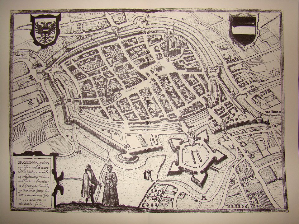
maps of groningen by braun & hogenberg
sconces in the netherlands
maps by jodocus hondius
bern new bern
leonardus schweickhardt
maps of ameland
engravings of topographia braunschweig lüneburg
baroque
maps of heilbronn by braun & hogenberg
st. johannes-kapelle (heilbronn)
maps by willem and johannes blaeu
atlas van loon
maps in the library of congress
hishikawa school,ukiyo-e
maps in the library of congress
hishikawa school,ukiyo-e
maps in the library of congress
hishikawa school,ukiyo-e
maps in the library of congress
hishikawa school,ukiyo-e
maps in the library of congress
hishikawa school,ukiyo-e
maps in the library of congress
hishikawa school,ukiyo-e
maps in the library of congress
hishikawa school,ukiyo-e
maps in the library of congress
hishikawa school,ukiyo-e
maps in the library of congress
hishikawa school,ukiyo-e
maps in the library of congress
hishikawa school,ukiyo-e
maps in the library of congress
hishikawa school,ukiyo-e
maps in the library of congress
hishikawa school,ukiyo-e
1700s maps of rhineland-palatinate
maps of vangiones by sanson
maps of chester by braun & hogenberg
maps in the british museum
17th-century maps of vienna
maps by nicolaes visscher i
1660s maps of rhineland-palatinate
maps of vangiones by sanson
map of the circle of upper saxony by sanson
bibliothèque nationale de france
maps of jerez by braun & hogenberg
maps of conil by braun & hogenberg
maps of the islands of greece by marco boschini (1658)
old maps of karpathos
le royaume de france distingué by guillaume sanson
1724 maps of france
birds-eye view of seattle, 1884
seattle
bibliothèque nationale de france
maps of spain by tomas lopez
maps of spain by tomas lopez
18th-century maps of madrid
sanson maps of the circles of germany
1670s maps of baden-württemberg
nouvelle géographie universelle
1887 maps of africa
le royaume de france distingué by guillaume sanson
1724 maps of france
gottfried christian pingeling
1745 maps of hamburg
maps in the library of congress
1760 maps of north america
old maps of gâtinais and sénonais
maps by willem and johannes blaeu
15201 - 15300 of 26,489
Next page
/ 265