Log in
All resources
Create a design
545 Free Artworks of Hemispheres
bibliothèque nationale de france
17th-century double hemisphere world maps
eran laor cartographic collection
map
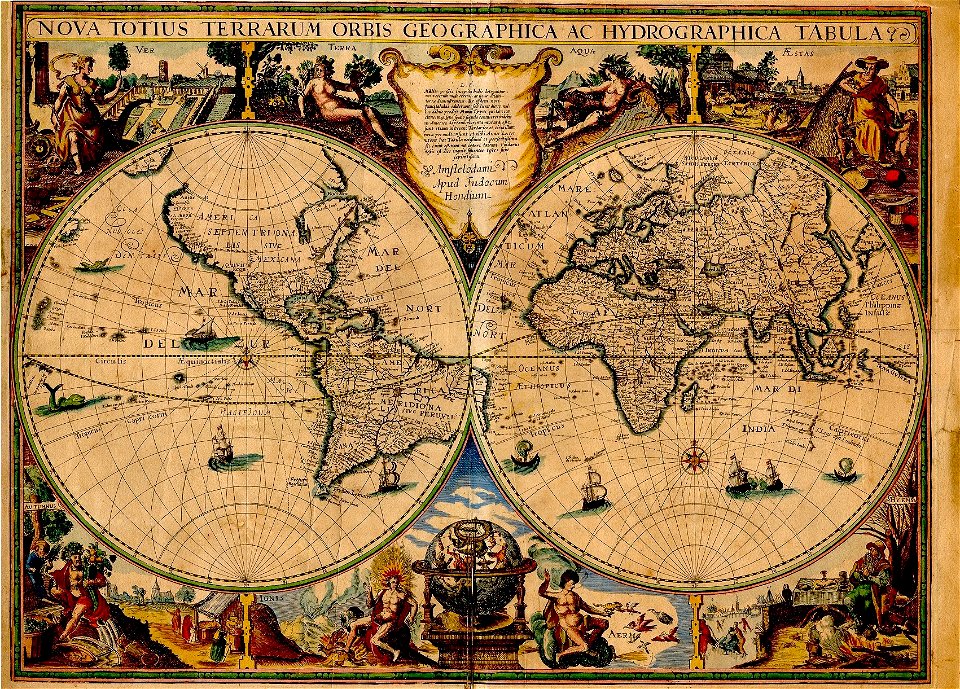
henricus hondius ii, nova totius terrarum orbis geographica ac hydrographica tabula, 1630
henricus hondius ii
national library of israel
island of california on world maps
baroque
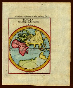
description de l'universe
bibliothèque nationale de france
guillaume sanson
bibliothèque nationale de france
guillaume sanson
island of california on world maps
1650s maps of the world
paintings in the national library of australia
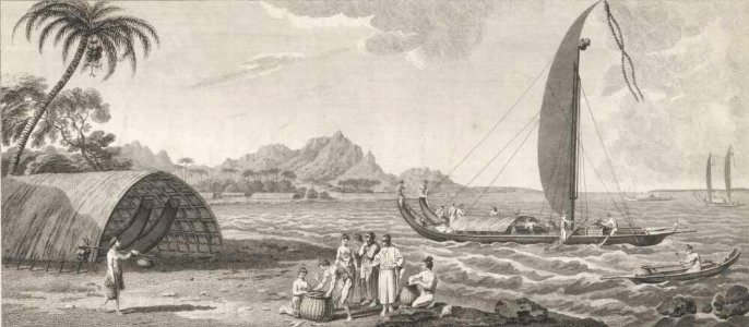
sydney parkinson
nypl lionel pincus and princess firyal map division
geographical atlases
eran laor cartographic collection
tranquillo mollo
codex arundel (c.1480-1518) - bl arundel ms 263
sketches of the moon
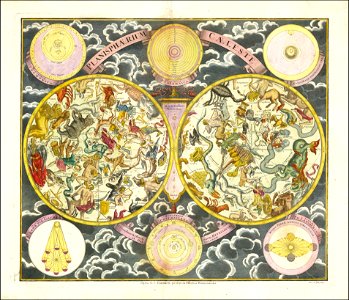
18th-century celestial maps
georg christoph eimmart
1800s maps of the americas
maps by john cary
mappe-monde geo-hydrographique (sanson and jaillot, 1674)
bibliothèque nationale de france
cingulate cortex
gyri
willis' circle and vertebrobasilar system
gray's anatomy plates
18th-century maps of antarctica
1741 maps
russian empire in thomas kitchen's general atlas (1773)
general atlas (1773)
tresor des cartes geographiques (1659)
1650s maps of the world
commemorative stamps of the united states
early renaissance,florentine school
high renaissance
codex windsor
mappe-monde geo-hydrographique (sanson and jaillot, 1674)
bibliothèque nationale de france
bibliothèque nationale de france
guillaume sanson
united states navy images from the atlantic ocean
ara almirante brown (d-10)
john james barralet
sydney parkinson
maps in the library of congress
1664 maps
jantar mantar (delhi)
thomas daniell
island of california on world maps
1680s maps of the world
16th-century double hemisphere world maps
1590s maps of the world
16th-century double hemisphere world maps
1590s maps of the world
john hall (engraver)
samuel wallis
satellite pictures of the eastern hemisphere
fra mauro map derivative works
1770s maps of the world
maps by tomas lopez
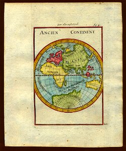
old maps of the western hemisphere
jacob van meurs
mappe-monde geo-hydrographique (sanson and jaillot, 1674)
bibliothèque nationale de france
maps by willem and johannes blaeu
novus atlas blaeu
1800s maps of the world
old maps of the world
1760s maps of the americas
1764 maps
old maps of the eastern hemisphere
1710s maps of the world
gray's anatomy plates of nervous system
svg human brain (sagittal section)
maps by joachim bormeester
1685 maps
old maps of the eastern hemisphere
1710s maps of the world
description de l'universe
1680s maps of the world
mappe-monde geo-hydrographique (sanson and jaillot, 1674)
bibliothèque nationale de france
copper engravings
1625 maps
description de l'universe
1710s maps of the world
old maps of bouvet island
bouvet island
old hemisphere world maps (partner files)
arnold's geographical handbook (1899)
17th-century double hemisphere world maps
description de l'universe
satellite pictures of the eastern hemisphere
fra mauro map derivative works
atlas maior, vol 1 (northern europe, norway, and denmark) - joan blaeu, 1667 - bl 114.h(star).1
17th-century double hemisphere world maps
aerial photographs of naval ships of argentina
ara almirante brown (d-10)
atlas minor gerardi mercatoris (1614, maps)
17th-century double hemisphere world maps
josef kořenský
zlatá praha
josef kořenský
zlatá praha
suriname collection in the etnografiska museet
axel klinckowström's expedition to suriname
old hemisphere world maps (partner files)
arnold's geographical handbook (1899)
17th-century double hemisphere world maps
1610s maps of the world
henricus hondius ii, nova totius terrarum orbis geographica ac hydrographica tabula, 1630
eran laor cartographic collection
old maps of the northern hemisphere
old maps of the arctic
maps by hendrik hondius the younger
1630s maps of the world
géographie générale; physique, politique et économique (1876)
19th-century maps of antarctica
géographie générale; physique, politique et économique (1876)
old maps of the western hemisphere
atlas ou representation du monde universel t. 1 (1633)
17th-century double hemisphere world maps
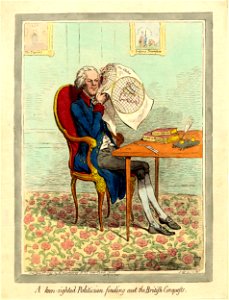
a keen-sighted politician finding out the british conquests
prints by james gillray in the british museum
17th-century double hemisphere world maps
mercator 1587 world map
old maps of bouvet island
bouvet island
old maps of the eastern hemisphere
1680s maps of the world
map collection of leibniz-institut für länderkunde
1800s maps of the world
old hemisphere world maps (partner files)
1800s maps of the world
jodocus hondius ii, nova totius terrarum orbis geographica ac hydrographica tabula, 1636
map
paintings of astronomers
olivier van deuren
victor levasseur - maps of the world
neoclassicism
henricus hondius ii, nova totius terrarum orbis geographica ac hydrographica tabula, 1630
eran laor cartographic collection
henricus hondius ii, nova totius terrarum orbis geographica ac hydrographica tabula, 1630
eran laor cartographic collection
henricus hondius ii, nova totius terrarum orbis geographica ac hydrographica tabula, 1630
eran laor cartographic collection
henricus hondius ii, nova totius terrarum orbis geographica ac hydrographica tabula, 1630
eran laor cartographic collection
henricus hondius ii, nova totius terrarum orbis geographica ac hydrographica tabula, 1630
eran laor cartographic collection
old maps of north america from the norman b. leventhal map center
old maps of south america from the norman b. leventhal map center
old maps of the northern hemisphere
1800s maps of the world
maps in the british museum
german renaissance
henricus hondius ii, nova totius terrarum orbis geographica ac hydrographica tabula, 1630
eran laor cartographic collection
maps in the library of congress
1690s maps of the world
collections of musée cernuschi
baroque
collections of musée cernuschi
baroque
collections of musée cernuschi
baroque
world war i posters in the library of congress
posters by ludwig hohlwein
henricus hondius ii, nova totius terrarum orbis geographica ac hydrographica tabula, 1630
eran laor cartographic collection
henricus hondius ii, nova totius terrarum orbis geographica ac hydrographica tabula, 1630
eran laor cartographic collection
1590s maps of the world
cornelis de jode
henricus hondius ii, nova totius terrarum orbis geographica ac hydrographica tabula, 1630
eran laor cartographic collection
henricus hondius ii, nova totius terrarum orbis geographica ac hydrographica tabula, 1630
eran laor cartographic collection
old maps of the western hemisphere
cornell's primary geography (1860)
maps by jodocus hondius
1590s maps of the world
photos of mercury by messenger
magritte (crater)
maps in the rijksmuseum amsterdam
maps by frederick de wit
18th-century double hemisphere world maps
1760s maps of the world
british caricatures and cartoons in the rijksmuseum amsterdam
caricatures of napoleon i of france
united states navy images from the atlantic ocean
ara almirante brown (d-10)
ceramics of the trần dynasty in the musée cernuschi
baroque
ceramics of vietnam in the musée cernuschi
baroque
ceramics of the trần dynasty in the musée cernuschi
baroque
ceramics of the trần dynasty in the musée cernuschi
baroque
collections of musée cernuschi
baroque
301 - 400 of 545
Next page
/ 6