Log in
All resources
Create a design
27,441 Free Images of Maps
gemeente atlas van nederland - north holland
1860s maps of north holland
bibliothèque nationale de france
eran laor cartographic collection
maps made in the 17th century
maps by willem and johannes blaeu
maps of alsace by guillaume sanson
old maps of the tribes of israel
new york public library
latin-language maps
spring morning in the han palace
women of the ming dynasty in art
eran laor cartographic collection
william hughes (geographer)
eran laor cartographic collection
baroque
jan huygen van linschoten
baptista van doetecum
eran laor cartographic collection
guillaume sanson
maps by willem and johannes blaeu
maps made in the 17th century
maps by willem and johannes blaeu
maps made in the 17th century
maps of alsace by guillaume sanson
1690s maps of baden-württemberg
theatre geographique du royaume de france (1632)
mercator 1587 world map
cartes generales de toutes les parties du monde (1658)
1650s maps of saxony
the british monarchy (1743)
maps in the british museum
maps by willem and johannes blaeu
maps made in the 17th century
maps made in the 17th century
old maps of upper austria
18th-century maps of rutland
maps in the british museum
maps of alsace by guillaume sanson
1660s maps of alsace
maps of alsace by guillaume sanson
1690s maps of baden-württemberg
17th-century maps of malta
maps by gerard valck
maps of alsace by guillaume sanson
1660s maps of baden-württemberg
maps by willem and johannes blaeu
maps made in the 17th century
the british monarchy (1743)
maps in the british museum
maps of alsace by guillaume sanson
1660s maps of alsace
synopsis universae philologiae
1741 maps of asia
lawrence h. slaughter collection of english maps, charts, globes, books and atlases
nypl lionel pincus and princess firyal map division
sheet 15 of the turgot map of paris
maps of paris by braun & hogenberg
frans hogenberg
the story of mexico (1889 book)
sheet 11 of the turgot map of paris
maps of south asia by mercator-hondius
maps of the punjab region
edward weller
cartouches by willem and johannes blaeu
cartouches by willem and johannes blaeu
old maps of dendermonde
atlas van loon
the story of mexico (1889 book)
valley of mexico
history of tienen
atlas van loon
maps of amsterdam by braun & hogenberg
maps of port of amsterdam
claes jansz. visscher (ii)
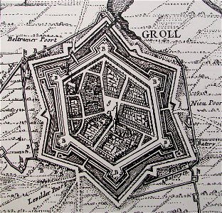
siege of groenlo 1627
eran laor cartographic collection
guillaume sanson
eran laor cartographic collection
jacob peeters
eran laor cartographic collection
jacob peeters
19th-century maps of the malay archipelago
19th-century maps of southeast asia
plan de roussel - derivative files
château de bercy
heresies of sea power (fred t. jane)
telecoupling
cartes de franz schrader
old maps of oran
maps of liège by johannes blaeu - derivative files
couvent des augustins de liège
media from regionaal archief alkmaar
scharwoude
media from regionaal archief alkmaar
winkel, north holland
east prospect of the city of philadelphia
independence hall in art
maps in the library of congress
cartouches by tomas lópez
baroque painting
animals on maps
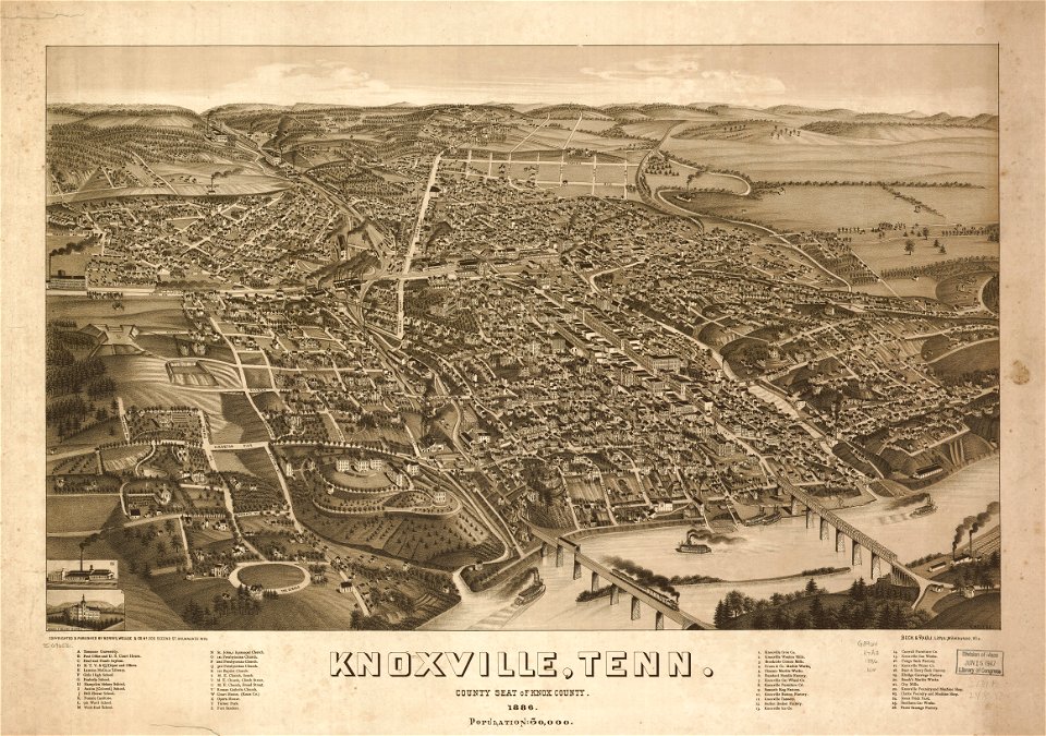
bird's eye view of knoxville, tennessee, 1886
maps in the library of congress
van langren map of southeast asia
1599 maps of asia
maps of paris from bibliothèque nationale de france
map of paris by claes jansz. visscher
van langren map of southeast asia
1599 maps of asia
atlas maior, vol 6 (scotland and ireland) - joan blaeu, 1667 - bl 114.h(star).6
1667 maps
nypl the miriam and ira d. wallach division of art, prints and photographs: print collection
impressionism
danubius pannonico-mysicus
drobeta
voyages and travels to india, ceylon, the red sea, abyssinia, and egypt, vol. 2
henry cooper (engraver)
history of weißenfels
baroque
gemeente atlas van nederland - limburg
19th-century maps of maastricht
storia degli antichi popoli italiani
old maps of tuscany
modernist literature
maps of florence
maps of dresden by braun & hogenberg
maps of leipzig by braun & hogenberg
curt teich postcard archives
postcards of oklahoma
maps from the earth and its inhabitants, vol. vi
shchurovsky glacier
maps from the earth and its inhabitants, vol. xi
africa in the 1890s
maps from the earth and its inhabitants, vol. xi
algeria in the 1800s
danubius pannonico-mysicus
1720s maps of hungary
maps of alhama de granada by braun & hogenberg
eran laor cartographic collection
maps from the earth and its inhabitants, vol. vi
shchurovsky glacier
picturesque tour from geneva to milan, by way of the simplon (1820)
maps from the mechanical curator collection
topographisch-historische ansicht der belagerung kopenhagens (1807)
maps from the mechanical curator collection
paintings by wybrand hendriks
proveniershof, haarlem
maps in the library of congress
1776 maps
hendrik van langren map of south asia
1595 maps of asia
hendrik van langren map of south asia
1595 maps of asia
wały jagiellońskie street in gdańsk
maps of gdańsk by braun & hogenberg
maps by jacob van meurs
old maps of iran
the dominion of portugal in africa (1889)
maps of cefala by braun & hogenberg
the new forest, its history and its scenery
symbolism
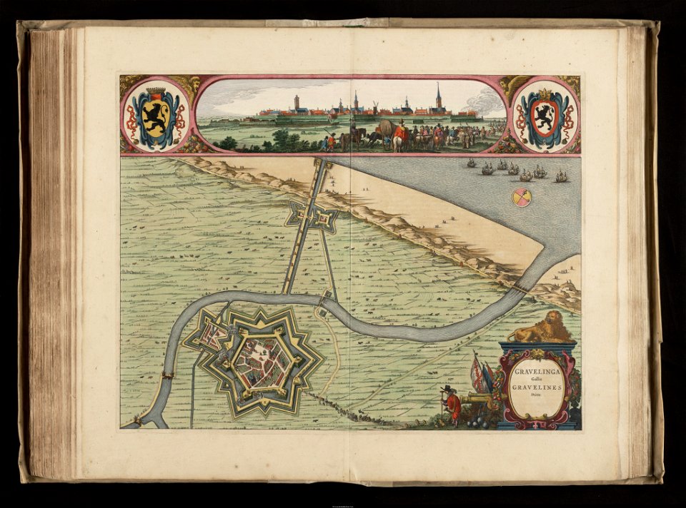
maps of gravelines city wall
old maps of gravelines
maps of polders in zeeland
old maps of sluis
gemeente atlas van nederland - north holland
maps of hoogwoud
gemeente atlas van nederland - north holland
maps of schellinkhout
gemeente atlas van nederland - north holland
maps of wognum
16th-century maps of istanbul
david kandel
gemeente atlas van nederland - north holland
maps of avenhorn
gemeente atlas van nederland - north holland
maps of hensbroek
old maps of westland
old maps of delfland
maps by willem and johannes blaeu
maps of montfoort
gemeente atlas van nederland - north holland
maps of wieringerwaard
maps from the earth and its inhabitants, vol. xii
africa in the 1890s
maps from the earth and its inhabitants, vol. xi
africa in the 1890s
gemeente atlas van nederland - north holland
maps of hoogkarspel
gemeente atlas van nederland - north holland
maps of ursem
gemeente atlas van nederland - north holland
maps of westzaan
gemeente atlas van nederland - north holland
maps of zwaag
gemeente atlas van nederland - north holland
maps of wormerveer
gemeente atlas van nederland - north holland
maps of wijdenes
topographia bohemiae moraviae et silesiae (merian)
baroque
maps from the earth and its inhabitants, vol. xi
africa in the 1890s
7901 - 8000 of 27,441
Next page
/ 275