Log in
All resources
Create a design
14 Free Images of Maps Of The Dutch Caribbean
published by frans buffa & zonen
maps in the rijksmuseum amsterdam
chromolithographs in the rijksmuseum amsterdam
gezigten uit neerland's west-indien
old maps of sint maarten
old maps of sint eustatius
old maps of saba
dutch-language maps
maps by pieter mortier
old maps of suriname
dutch-language maps
johannes ratelband
18th-century maps of hispaniola
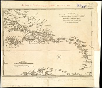
1780s maps of the caribbean
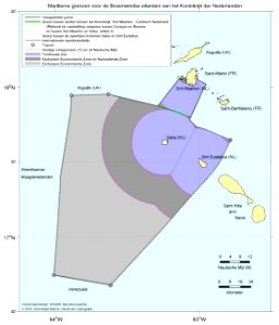
territorial waters
card
1720s maps of the caribbean
maps by pieter mortier
maps in the rijksmuseum amsterdam
published by frans buffa & zonen
maps in the rijksmuseum amsterdam
published by frans buffa & zonen
1690s maps of the caribbean
1690s maps of the americas
a map of the british empire in america with the french and spanish settlements adjacent thereto
1730s maps of the caribbean
maps in the rijksmuseum amsterdam
published by frans buffa & zonen
a map of the british empire in america with the french and spanish settlements adjacent thereto
1730s maps of the caribbean
maps in the rijksmuseum amsterdam
published by frans buffa & zonen
maps in the rijksmuseum amsterdam
published by frans buffa & zonen
old maps of the western hemisphere
jacob van meurs
1696 maps of the caribbean
1690s maps of mexico
1 - 14 of 14
/ 1