Log in
All resources
Create a design
107 Free Images of French Language Maps Of Spain
bibliothèque nationale de france
guide joanne espagne et portugal-1915
1915 maps
guide joanne espagne et portugal-1906
1906 maps
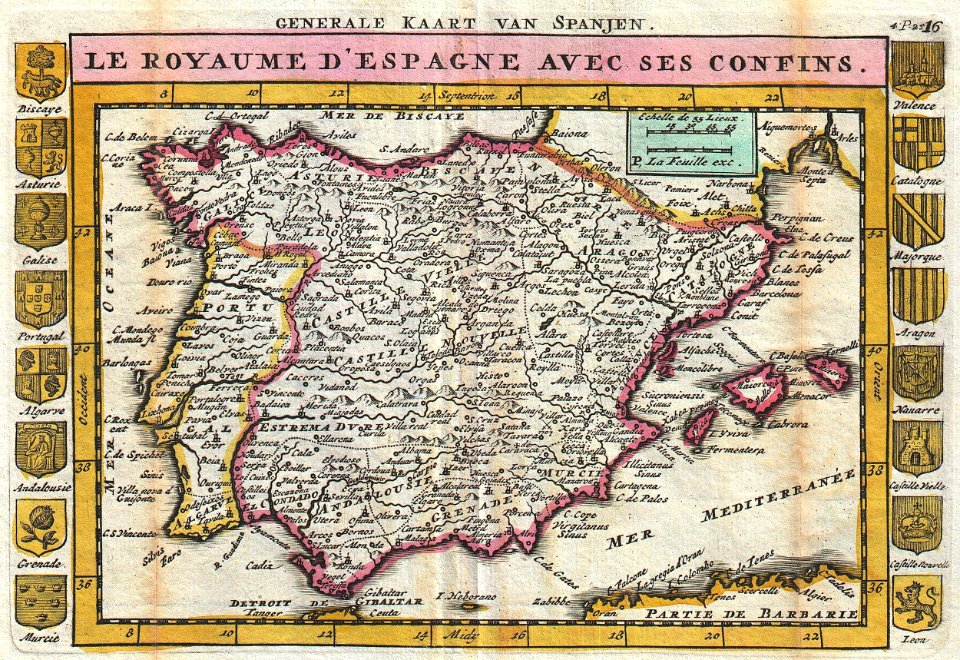
maps of the iberian peninsula by guillaume delisle
1700s maps of the iberian peninsula
1701 maps of spain
1700s maps of portugal
lucas janszoon waghenaer
old maps of the iberian peninsula
johannes ratelband
french-language maps
johannes ratelband
19th-century satirical maps
1899 maps of europe
1906 maps of europe
1906 in spain
1906 maps of europe
1906 in spain
guide joanne espagne et portugal-1915
1915 maps
guide joanne espagne et portugal-1915
1915 maps
guide joanne espagne et portugal-1915
1915 maps
guide joanne espagne et portugal-1915
1915 maps
guide joanne espagne et portugal-1906
french-language maps of spain
guide joanne espagne et portugal-1906
french-language maps of spain
guide joanne espagne et portugal-1906
french-language maps of spain
guide joanne espagne et portugal-1915
1915 maps
guide joanne espagne et portugal-1915
1915 maps
guide joanne espagne et portugal-1915
1915 maps
guide joanne espagne et portugal-1906
french-language maps of spain
guide joanne espagne et portugal-1906
french-language maps of spain
guide joanne espagne et portugal-1915
1915 maps
guide joanne espagne et portugal-1906
french-language maps of spain
guide joanne espagne et portugal-1906
french-language maps of spain
guide joanne espagne et portugal-1915
1915 maps
guide joanne espagne et portugal-1915
1915 maps
guide joanne espagne et portugal-1906
french-language maps of spain
guide joanne espagne et portugal-1915
1915 maps
guide joanne espagne et portugal-1915
1915 maps
guide joanne espagne et portugal-1915
1915 maps
guide joanne espagne et portugal-1915
1915 maps
guide joanne espagne et portugal-1906
french-language maps
guide joanne espagne et portugal-1915
1915 maps
guide joanne espagne et portugal-1915
1915 maps
guide joanne espagne et portugal-1915
1915 maps
guide joanne espagne et portugal-1906
french-language maps
maps of the iberian peninsula by guillaume delisle
1780s maps of the iberian peninsula
guide joanne espagne et portugal-1906
french-language maps
guide joanne espagne et portugal-1915
1915 maps
maps of the iberian peninsula by guillaume delisle
1700s maps of the iberian peninsula
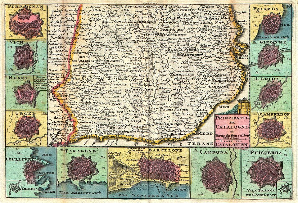
18th-century maps of catalonia
daniel de la feuille
maps of the iberian peninsula by guillaume delisle
1700s maps of the iberian peninsula
maps of the iberian peninsula by guillaume delisle
1700s maps of the iberian peninsula
maps of the iberian peninsula by guillaume delisle
1700s maps of the iberian peninsula
1800s maps of the iberian peninsula
maps of spain by tomas lopez
maps of barcelona by braun & hogenberg
1645 in andalusia
maps of the iberian peninsula by guillaume delisle
eran laor cartographic collection
1760s maps of the iberian peninsula
1762 maps of spain
vigo in the 18th century
1702 maps of spain
maps of tangier by braun & hogenberg
maps of asilah by braun & hogenberg
1810s maps of the iberian peninsula
1813 maps of spain
18th-century maps of central america
1760s maps of the caribbean
lucas janszoon waghenaer
1580s maps of spain
l'espagne divisée by guillaume sanson
1670s maps of the iberian peninsula
panoramic maps of seville by braun & hogenberg
maps of cadiz by braun & hogenberg
maps by pieter van der keere
ships on maps
18th-century maps of western europe
1754 maps of europe
maps of burgos by braun & hogenberg
1645 in spain
maps of granada by braun & hogenberg
bibliothèque nationale de france
l'espagne divisée by guillaume sanson
1690s maps of the iberian peninsula
maps of jerez by braun & hogenberg
maps of conil by braun & hogenberg
maps of setenil de las bodegas by braun & hogenberg
maps of lebrija by braun & hogenberg
maps of santander by braun & hogenberg
bibliothèque nationale de france
maps of peñón de vélez by braun & hogenberg
maps of tunis by braun & hogenberg
1750s maps of california
1705 maps of california
andalusia in the 1590s
1590s maps of spain
atlas géographique des quatre parties du monde (delisle)
18th-century maps of the iberian peninsula
maps of mexico city by braun & hogenberg
maps of cusco by braun & hogenberg
walls of olivenza, badajoz
maps of olivenza
die zee custen van biscaijen tusschen laredo ende sentillana soe hem dat selve landt all daer verthoont ennde opdoet - lucas ioannes aurigarius inventor ; ioannes à doetecum fecit - btv1b531945334
1580s maps of spain
sanson maps of the netherlands
1680s maps of the netherlands
17th-century maps of paraguay
1668 maps of south america
maps by jean-baptiste bourguignon d'anville
18th-century maps of western europe
maps of antequera by braun & hogenberg
bibliothèque nationale de france
carte du mexique et de la floride by guillaume delisle (1703)
bibliothèque nationale de france
les monts pyrénées, où sont remarques les passages de france en espagne dressé sur les mémoires les plus nouveaux - par le sr. sanson... - btv1b532269750
1688 maps of europe
l'espagne divisée by guillaume sanson
1680s maps of the iberian peninsula
françois de la pointe
maps of barbary coast
maps published by hendrik de leth
algiers in the 18th century
maps of alhama de granada by braun & hogenberg
bibliothèque nationale de france
maps of bilbao by braun & hogenberg
bibliothèque nationale de france
17th-century maps of africa
maps from gallica
context files from gallica
french text
caerte vande zee custen van arcason ende biscaien met heure havenen ende opdoeninghe van landen ende geberchten - doer lucas iansz wagenaer ; ioannes à doetecum f. - btv1b53156734s
bibliothèque nationale de france
caerte vande zee custen van arcason ende biscaien met heure havenen ende opdoeninghe van landen ende geberchten - doer lucas iansz wagenaer ; ioannes à doetecum f. - btv1b53156734s
bibliothèque nationale de france
caerte vande zee custen van arcason ende biscaien met heure havenen ende opdoeninghe van landen ende geberchten - doer lucas iansz wagenaer ; ioannes à doetecum f. - btv1b53156734s
bibliothèque nationale de france
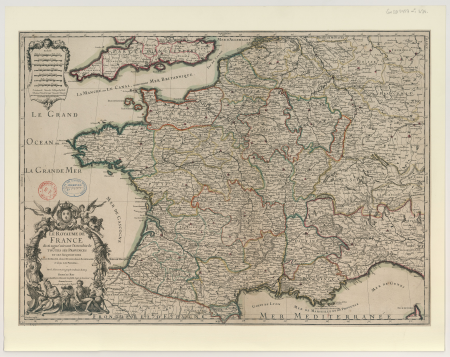
le royaume de france distingué by guillaume sanson
1689 maps of france
context files from gallica
french text
old maps of the kingdom of naples
1700s maps of italy
le royaume de france distingué by guillaume sanson
maps by nicolas sanson
1690s maps of the caribbean
1690s maps of the americas
carte du mexique et de la floride by guillaume delisle (1703)
bibliothèque nationale de france
die zee custen van biscaijen tusschen laredo ende sentillana soe hem dat selve landt all daer verthoont ennde opdoet - lucas ioannes aurigarius inventor ; ioannes à doetecum fecit - btv1b531945334
bibliothèque nationale de france
die zee custen van biscaijen tusschen laredo ende sentillana soe hem dat selve landt all daer verthoont ennde opdoet - lucas ioannes aurigarius inventor ; ioannes à doetecum fecit - btv1b531945334
bibliothèque nationale de france
le royaume de france distingué by guillaume sanson
1708 maps of france
beschrijvinge der zee custen van gallissien beginnende van capo de finisterre tot camino, gemaeckt naet wesen ende gedaente - lucas io(ann)es aurigarius inventor - btv1b53194534k
bibliothèque nationale de france
beschrijvinge der zee custen van gallissien beginnende van capo de finisterre tot camino, gemaeckt naet wesen ende gedaente - lucas io(ann)es aurigarius inventor - btv1b53194534k
bibliothèque nationale de france
beschrijvinge der zee custen van gallissien beginnende van capo de finisterre tot camino, gemaeckt naet wesen ende gedaente - lucas io(ann)es aurigarius inventor - btv1b53194534k
bibliothèque nationale de france
maps of andalusia by mercator-hondius
bibliothèque nationale de france
carte du mexique et de la floride by guillaume delisle (1703)
bibliothèque nationale de france
maps by nicolas sanson
1720s maps of france
1760s maps of the americas
jean janvier
carte du mexique et de la floride by guillaume delisle (1703)
bibliothèque nationale de france
die zee caerte van portugal; tusschen camino en montego, alsoe dat landt all daer in sijn ghedaente is, met alle sijne haeven enn ondiepten, met groeter naersticheijt en vliedt ghecorrigeert - btv1b531945351
bibliothèque nationale de france
1 - 100 of 107
Next page
/ 2


![Olivença / [A. Coquart Sculp.], Antoine Coquart, 1705](https://cdn.creazilla.com/illustrations/10000286512/olivena-a-coquart-sculp-antoine-coquart-1705-sm.webp)


![Paraguay taken from the most recent reports / by G[uillaume] Sanson, 1668](https://cdn.creazilla.com/illustrations/10000773533/paraguay-taken-from-the-most-recent-reports-by-g-uillaume-sanson-1668-sm.jpg)