Log in
All resources
Create a design
155 Free Images of Atlantic Coast
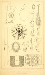
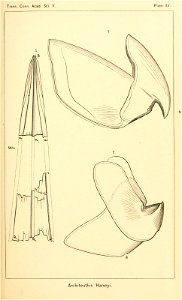
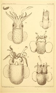
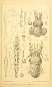
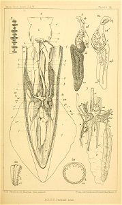
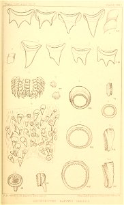
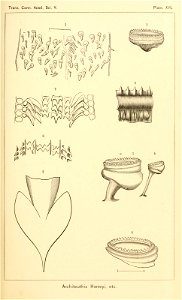
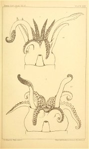
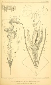
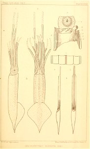
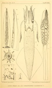
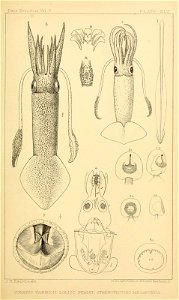
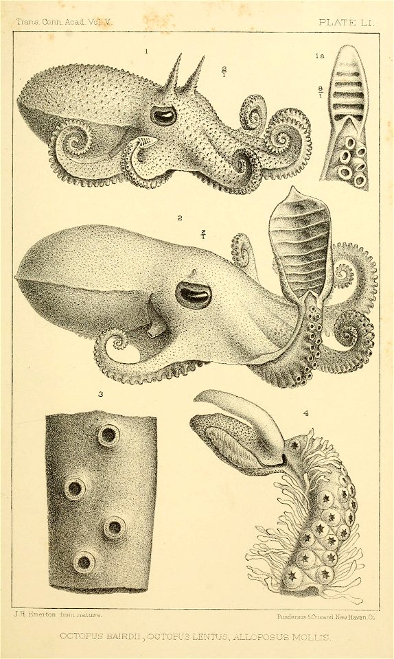
squid
north america
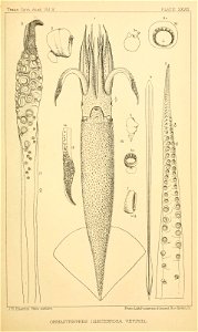
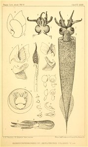
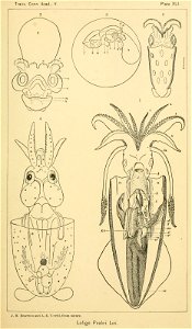
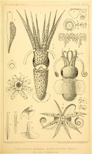
cephalopoda
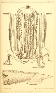
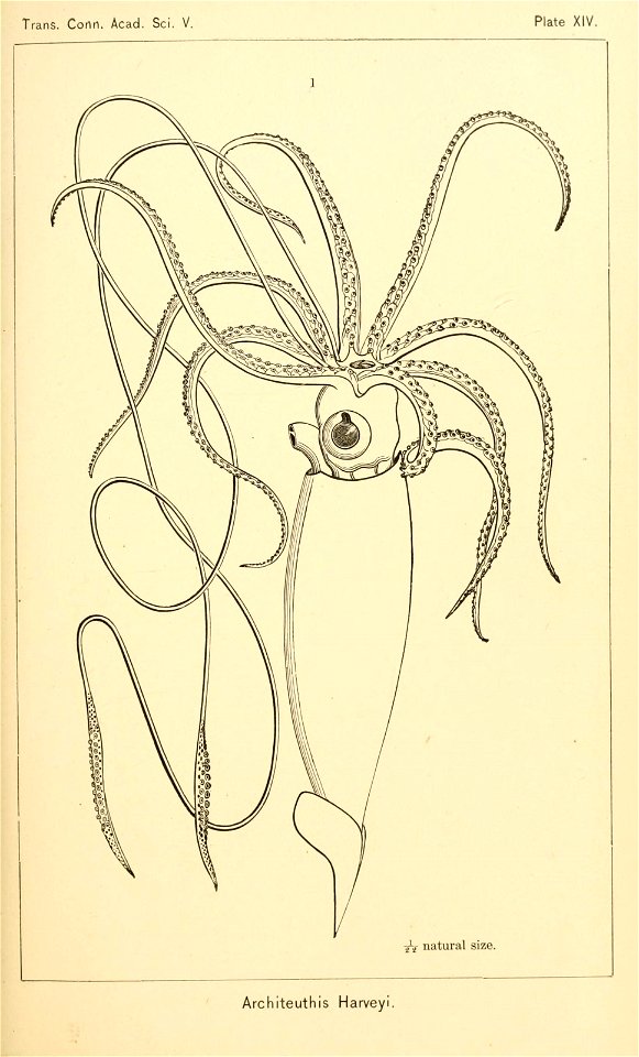
giant squid
mblwhoi library
#bhlmonstersrreal
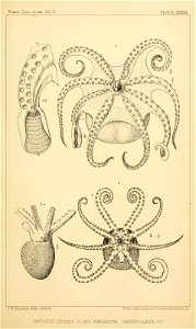
octopus 2
squid & octopuses
atlantic coast (north america)
bibliothèque nationale de france
slavery in saint-domingue (haiti)
africans in 19th-century art
july 2001 in north carolina
diving bells
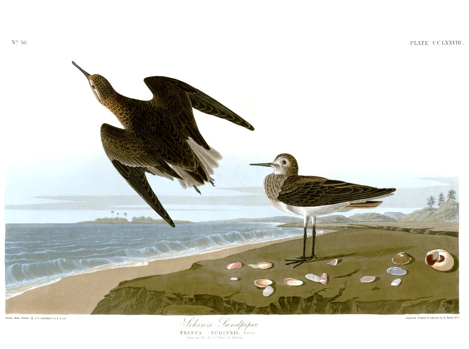
scolopacidae of the united states
birds of florida
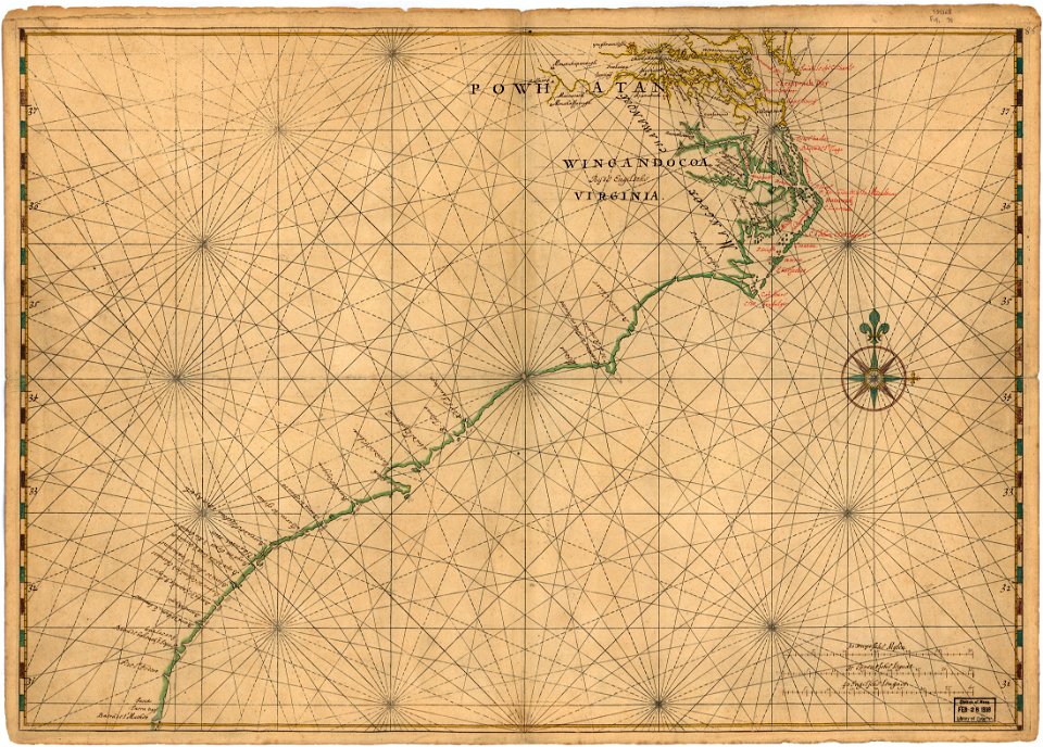
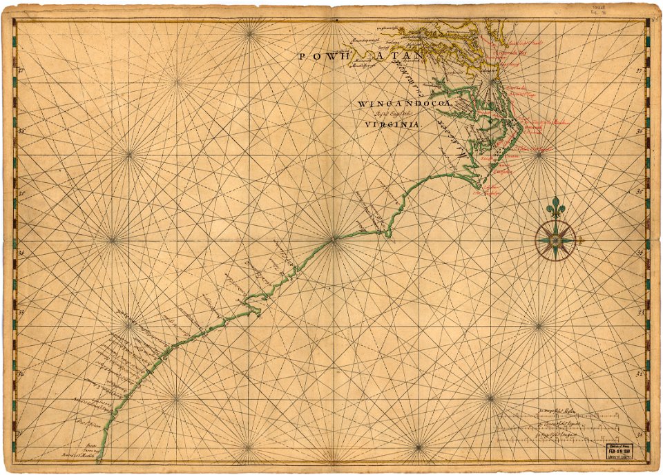
maps in the library of congress
old maps of maryland
maps in the library of congress
old maps of maryland
images from abbott and holder
1910s paintings
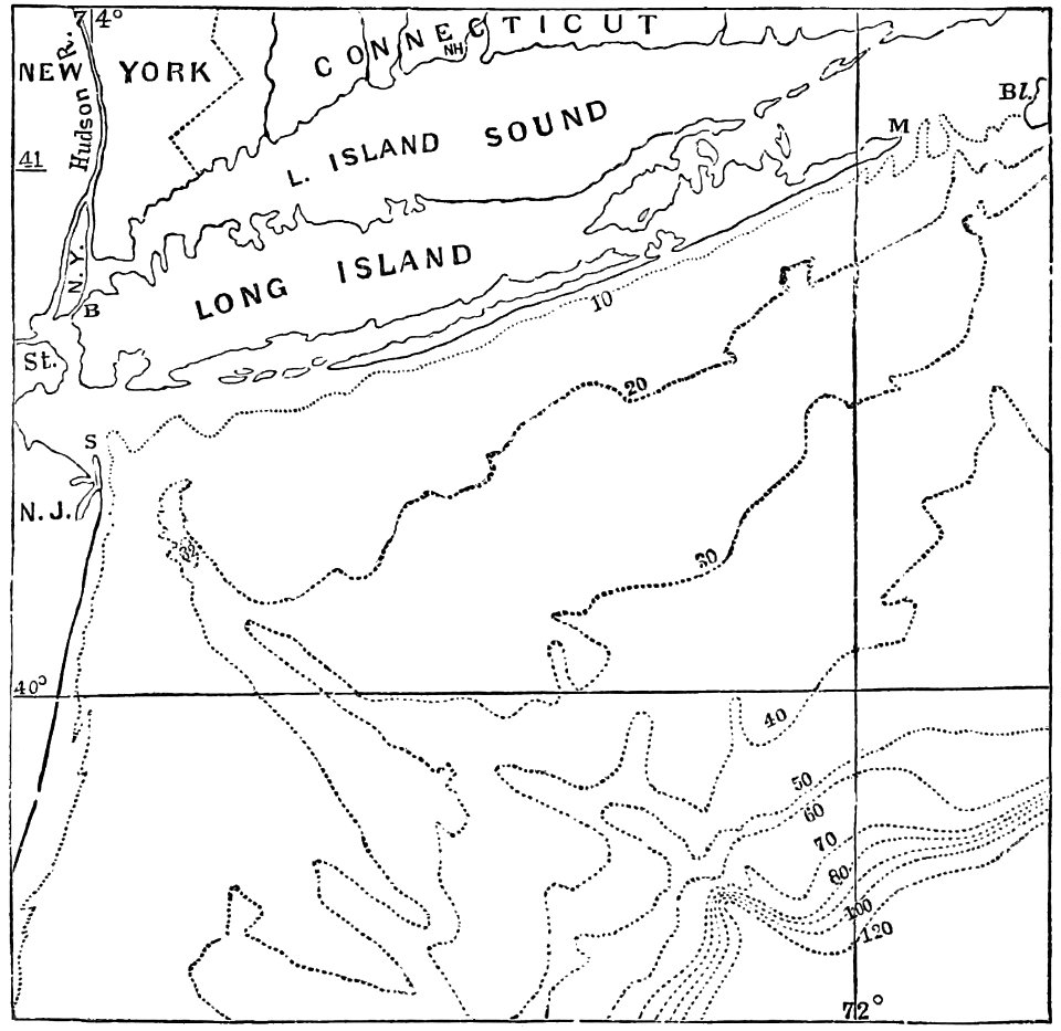
coasts of the united states
ocean topography
atlas blaeu-van der hem
elmina castle in art
independence seaport museum
thomas birch (1779-1851)
ruth and elmer wellin museum of art
realism,ashcan school
1870s maps of the atlantic ocean
the bottom of the sea (1870)
brooklyn rapid transit company
atlantic avenue control house
the bottom of the sea (1870)
distance
cleopatra's barge (ship, 1816)
1818 paintings
united states navy images from the atlantic ocean
ara almirante brown (d-10)
north america
squid
north america
squid
north america
squid
north america
squid
north america
squid
north america
squid
north america
squid
north america
squid
north america
squid
north america
squid
north america
squid
north america
squid
north america
squid
north america
squid
north america
squid
north america
squid
north america
squid
curt teich postcard archives, detroit publishing company
postcards of mount desert island
halloween
squid
north america
squid
north america
squid
octopus
squid
octopus
squid
ss great eastern in art
robert charles dudley
paintings in the aberdeen archives, gallery and museums
william lee hankey
french paintings in the museum boijmans van beuningen
impressionism
black and white photographs of paintings
pavel svinyin
paintings by françois-auguste biard
wilberforce house
maps in the british museum
1780s maps of france
north america
squid
16th-century maps of the western mediterranean
lucas janszoon waghenaer
octopus
squid
ara almirante brown (d-10)
bns bosisio (f 48)
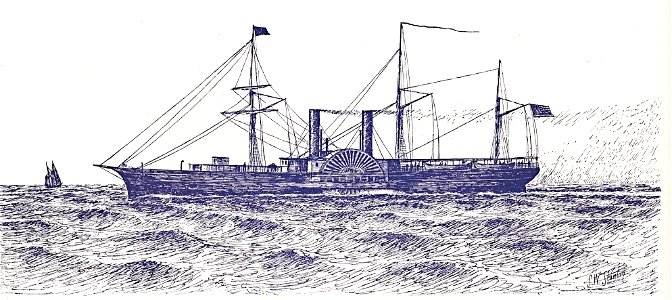
stanton drawings 1881-1890 vessels
parthian (ship, 1887)
stanton drawings 1881-1890 vessels
parthian (ship, 1887)
stanton drawings 1851-1860 vessels
illinois (ship, 1851)
stanton drawings 1851-1860 vessels
illinois (ship, 1851)
context files from gallica
lucas janszoon waghenaer
context files from gallica
lucas janszoon waghenaer
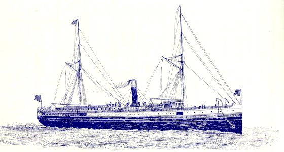
stanton drawings 1871-1880 vessels
city of augusta (ship, 1880)
north american shore birds (1895)
tringa nebularia (illustrations)
recurvirostra americana (illustrations)
north american shore birds (1895)
north american shore birds (1895)
limosa limosa (illustrations)
paintings by alfred thompson bricher
hudson river school,luminism
united states navy images from the atlantic ocean
ara almirante brown (d-10)
maps of the south atlantic
guillaume dheulland
1640s maps of ireland
baroque
stanton drawings 1851-1860 vessels
vanderbilt (ship, 1857)
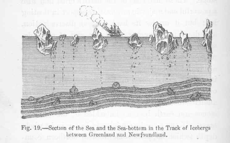
icebergs in the atlantic ocean
the bottom of the sea (1870)
imperial german navy
willy stöwer
stanton drawings 1851-1860 vessels
s.r. spaulding (ship, 1859)
1690s maps of the caribbean
1690s maps of the americas
arnold van langren map of southwest africa
bibliothèque nationale de france
beschrijvinghe der zee custen vant landt van argarbe, ende een deel vande condado, soe hem tlandt aldaer verthoont ende in ghedaente ende wesen is - lucas io(ann)es aurigarius inventor ; ioannes à doetecum... - btv1b53194476r
bibliothèque nationale de france
beschrijvinghe der zee custen vant landt van argarbe, ende een deel vande condado, soe hem tlandt aldaer verthoont ende in ghedaente ende wesen is - lucas io(ann)es aurigarius inventor ; ioannes à doetecum... - btv1b53194476r
bibliothèque nationale de france
beschrijvinghe der zee custen vant landt van argarbe, ende een deel vande condado, soe hem tlandt aldaer verthoont ende in ghedaente ende wesen is - lucas io(ann)es aurigarius inventor ; ioannes à doetecum... - btv1b53194476r
bibliothèque nationale de france
portolan charts made in the 17th century
maps by willem and johannes blaeu
the illustrated london news 1889
josiah robert wells
arnold van langren map of southwest africa
renaissance
arnold van langren map of southwest africa
1596 maps of africa
corsica in the 20th century
guido colucci
old maps of the chesapeake bay
sir walter raleigh
old maps of the united states
copper engravings
ambroise tardieu
j. p. besançon
ara almirante brown (d-10)
sps santa maría (f81)
cleopatra's barge (ship, 1816)
george ropes
ocean monarch (ship, 1848)
samuel walters
aerial photographs of naval ships of argentina
ara almirante brown (d-10)
engineman (united states navy)
recovery of uss monitor parts
ocean monarch by samuel walters
samuel walters
context files from gallica
french text
lucas janszoon waghenaer
1580s maps of spain
the illustrated london news 1889
paul naumann (engraver)
lawrence h. slaughter collection of english maps, charts, globes, books and atlases
covens en mortier
the generall historie of virginia (john smith)
1624 books from london
context files from gallica
french text
lawrence h. slaughter collection of english maps, charts, globes, books and atlases
covens en mortier
travel
boat
demolitions in the hague for the atlantic wall
photographs by menno huizinga
marine paintings by carl frederik sørensen
1847 landscape paintings from denmark
old maps of the russian empire
1790s maps of alaska
arnold van langren map of southwest africa
renaissance
old geological maps by jean-etienne guettard
jean étienne guettard
andalusia in the 1590s
1590s maps of spain
beschrijvinge der zee custen van gallissien beginnende van capo de finisterre tot camino, gemaeckt naet wesen ende gedaente - lucas io(ann)es aurigarius inventor - btv1b53194534k
bibliothèque nationale de france
1 - 100 of 155
Next page
/ 2