Log in
All resources
Create a design
653 Free Images of 1876 Maps
charles eugène perron
géographie générale; physique, politique et économique (1876)
nouvelle géographie universelle, vol. xii
19th-century maps of the azores
africa and its inhabitants, vol. ii
the comprehensive history of england (1876)
english-language maps showing history
1870s maps showing history
19th-century maps of madeira
the geographical distribution of animals (book)
maps from the earth and its inhabitants, vol. vi
maps indicating exploration
1876 maps
1884 maps
1876 maps
1884 maps
nouvelle géographie universelle, vol. i
maps showing 19th-century history
the geographical distribution of animals (book)
zoogeography
media from the national library of finland
classicism
frank leslie's illustrated newspaper, 1876
maps in the library of congress
maps from the earth and its inhabitants, vol. vi
maps of journeys
lithographs of paris
floor plans of paris
maps of lake chad
gustav nachtigal
nouvelle géographie universelle, vol. xii
charles eugène perron
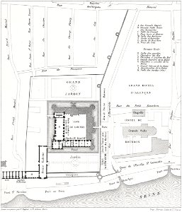
lithographs of paris
floor plans of paris
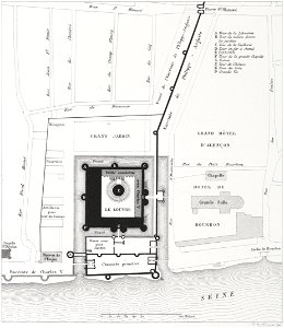
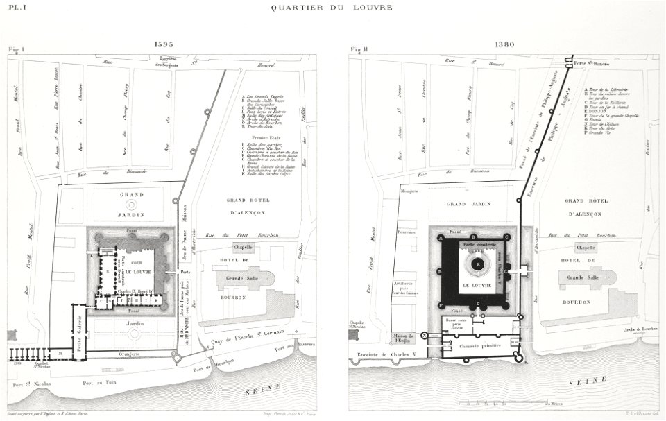
engravings of louvre by theodor hoffbauer
lithographs of paris
pictorial maps of the world
1876 maps of the world
nouvelle géographie universelle, vol. xii
charles eugène perron
nouvelle géographie universelle, vol. xii
charles eugène perron
africa and its inhabitants, vol. ii
charles eugène perron
nouvelle géographie universelle, vol. xii
charles eugène perron
lithographs of paris
floor plans of paris
africa and its inhabitants, vol. ii
charles eugène perron
1876 paintings
academic art
the geographical distribution of animals (book)
palearctic
old maps of douarnenez
old maps of brest
engravings of louvre by theodor hoffbauer
lithographs of paris
the geographical distribution of animals (book)
maps of ecozones
nouvelle géographie universelle, vol. xii
charles eugène perron
nouvelle géographie universelle, vol. xii
charles eugène perron
nouvelle géographie universelle, vol. xii
charles eugène perron
nouvelle géographie universelle, vol. xii
charles eugène perron
maps in the library of congress
1876 maps of pennsylvania
africa and its inhabitants, vol. ii
charles eugène perron
old maps of cities in switzerland
maps of biel/bienne
africa and its inhabitants, vol. ii
charles eugène perron
africa and its inhabitants, vol. ii
charles eugène perron
nouvelle géographie universelle, vol. xii
charles eugène perron
nouvelle géographie universelle, vol. xii
charles eugène perron
nouvelle géographie universelle, vol. xii
charles eugène perron
nouvelle géographie universelle, vol. xii
charles eugène perron
the geographical distribution of animals (book)
afrotropic
the geographical distribution of animals (book)
nearctic
the geographical distribution of animals (book)
neotropic
the geographical distribution of animals (book)
indomalayan fauna
africa and its inhabitants, vol. ii
charles eugène perron
africa and its inhabitants, vol. ii
charles eugène perron
maps from géographie illustrée de la france et de ses colonies
orientalist painting
norwegian north-atlantic expedition (1876-1878)
old maps of jan mayen
charles eugène perron
old maps of trabzon
africa and its inhabitants, vol. ii
charles eugène perron
1876 maps of north america
1876 maps of the caribbean
dr. wilh. junker's reisen in afrika 1875-1886
old maps of khartoum
the geographical distribution of animals (book)
australasia
africa and its inhabitants, vol. ii
charles eugène perron
maps of rivers of equatorial guinea
komo (river)
engravings of louvre by theodor hoffbauer
lithographs of paris
austro-hungarian north pole expedition
maps of franz joseph land
africa and its inhabitants, vol. ii
charles eugène perron
the comprehensive history of england (1876)
english-language maps showing history
19th-century maps of nicaragua
bedford pim
french-language maps of south africa
1876 maps of africa
1876 maps of the united states
old maps of new england
old maps of the sea of galilee
french-language maps
victor levasseur - maps of the world
coats of arms of switzerland
nouvelle géographie universelle, vol. xii
1890s maps of africa
dr. wilh. junker's reisen in afrika 1875-1886
1889 maps of sudan
the comprehensive history of england (1876)
english-language maps showing history
géographie générale; physique, politique et économique (1876)
19th-century maps of bretagne
géographie générale; physique, politique et économique (1876)
old maps of the strait of gibraltar
1700s maps of germany
battle of blenheim
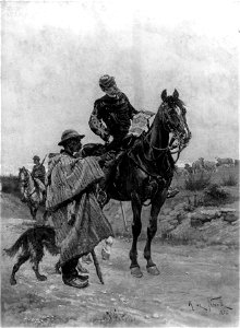
engravings from michael strogoff by charles barbant
illustrations from michael strogoff by jules férat
engravings from michael strogoff by charles barbant
illustrations from michael strogoff by jules férat
old maps of el hierro
history of el hierro
1870s maps of libya
ghadames
géographie générale; physique, politique et économique (1876)
1876 maps of germany
géographie générale; physique, politique et économique (1876)
1876 maps of germany
géographie générale; physique, politique et économique (1876)
1876 maps of india
géographie générale; physique, politique et économique (1876)
1870s maps of liguria
africa and its inhabitants, vol. ii
charles eugène perron
africa and its inhabitants, vol. ii
charles eugène perron
géographie générale; physique, politique et économique (1876)
1870s maps of germany
nouvelle géographie universelle, vol. xii
old maps of la gomera
géographie générale; physique, politique et économique (1876)
1870s maps of china
géographie générale; physique, politique et économique (1876)
hydrographic maps of argentina
géographie générale; physique, politique et économique (1876)
1876 maps of italy
géographie générale; physique, politique et économique (1876)
19th-century maps of pomerania
géographie générale; physique, politique et économique (1876)
18th-century maps of alpes-maritimes
géographie générale; physique, politique et économique (1876)
1876 maps of turkey
nouvelle géographie universelle, vol. xii
old maps of saint-louis (senegal)
maps from the earth and its inhabitants, vol. ix
old maps of samsun
the comprehensive history of england (1876)
english-language maps showing history
the comprehensive history of england (1876)
english-language maps showing history
the comprehensive history of england (1876)
english-language maps showing history
the comprehensive history of england (1876)
english-language maps showing history
the comprehensive history of england (1876)
english-language maps showing history
the comprehensive history of england (1876)
english-language maps showing history
the comprehensive history of england (1876)
english-language maps showing history
the comprehensive history of england (1876)
english-language maps showing history
the comprehensive history of england (1876)
english-language maps showing history
old maps of pyrénées-orientales
coats of arms of perpignan
maps from the earth and its inhabitants, vol. ix
maps of beirut
maps from the earth and its inhabitants, vol. ix
old maps of baghdad
1 - 100 of 653
Next page
/ 7