Polyglot Maps of the Continents, 1741

Polyglot Maps of the Continents, 1741

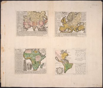
(full title) asia polyglotta, linguarum genealogiam cum literis, scribundique modis exhibens; europa polyglotta, linguarum genealogiam exhibens, una cum literis, scribendique modis, omnium gentium; africa polyglotta scribendi modos gentium exhibens; america cum supplementis polyglottis. Date: 1741. Dimensions: (cm, H x W) each map 16 x 21. Collection: Cornell University Library.
Edit image
Published by:
Creazilla
Author: Hensel, Gottfried.Source: commons.wikimedia.org

Loading...

0 downloads
Loading...
cornell: persuasive cartography: the pj mode collectionmaps of continentsmaps of writing systems in the worldsynopsis universae philologiae1740s maps of the world1741 maps of europe1741 maps of asia1741 maps of africa1740s maps of the americasisland of californiacornell university library

MORE LIKE THIS

Creazilla logo
Over 10 million free graphic resources for content creators and designers.
© 2018 - 2025 Creazilla
Our resourcesAll imagesPhotosDigital illustrationsClipartIconsPNG ImagesEmojisSilhouettesTraditional Art3D ModelsVectorsFontsColor namesColor palettesGradientsAudioAnimationVideosTemplates
InformationAbout CreazillaTerms of useTech teamPrivacy policyLicence Information
FeedbackContact Us