Map of Essequebo and Demerary, Jakob van der Schley, circa 1770
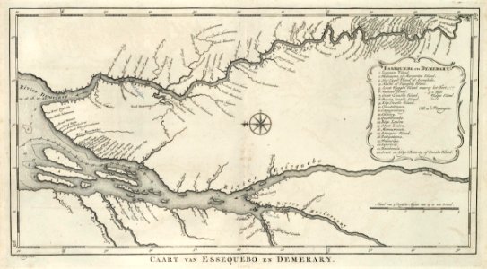
Map of essequebo and demerary. Kaart van essequebo en demerary. Key: essequebo en demerary / 1. Leguaan eiland. / 2. Wockenama of margariten eiland. / 3. Het tyger eiland of arowabiche. 4. Nieuwe of papegaay eiland. / 5. Groot vlaggen eiland waarop het fort. /. . 5a klyn vlagge eiland. / 6. Varkens eiland. / 7 groot trouille eiland. / 8 bouria banalle eiland / 9. Klyn trouille eiland. / 10 coucetrittecure. / 11. Couaypouloury. / 12. Cacotiry. / 13. Quattebanabo. / 14. Klyn loulou. / 15. Groot loulou. / mawouwecoute. / 17 stampers eiland. / 18. Pattepateyma. / 19 waicouripa. / 20 kykoveral. / 21 bahabenala. / 22. Groot en klyn batavia of creoolen eiland. Nb. Plantagiën. In the demerary river, the location of the island of borsselen river has been altered in pencil. The masserouny river also features a change to the location of cartabo. Date: circa 1770. Dimensions: height: 40.5 cm (15.9 in); width: 20.5 cm (8 in). Medium: engraving on paper. Collection: Koninklijke Bibliotheek. AMH-6905-KB Map of Essequebo and Demerary