Hunan, 5th Province of the Chinese Empire, Joan Blaeu

Hunan, 5th Province of the Chinese Empire, Joan Blaeu

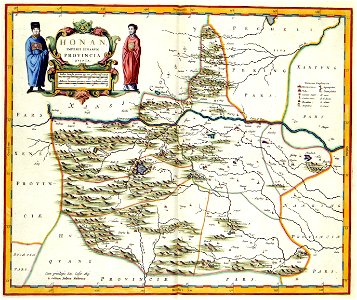
The map of the chinese province hunan was part of an atlas of china composed by the italian missionary martino martini (1614-1661). On his way back to rome, martini stopped in amsterdam where he sold his atlas to joan blaeu (1598-1673). From 1655 blaeu published martinis atlas as the atlas sinensis", the atlas of china, in several languages. The atlas sinensis also became an integral part of the atlas maior in 1662. Object Type: map. Date: 1690, from a 1655 original. Place of creation: Amsterdam. Dimensions: 40 x 48 cm. Medium: copper engraving print. Collection: Koninklijke Bibliotheek. Atlas Van der Hagen-KW1049B13 040-HONAN. IMPERII SINARVM PROVINCIA QVINTA
Edit image
Published by:
Creazilla
Author: Martino Martini (1614–1661) Author: Martini Martino Publisher: Joan Blaeu (1596–1673)Source: commons.wikimedia.org

Loading...

0 downloads
Loading...
atlas van der hagenatlas van der hagen (volume 4)old maps of henanmaps with figuresnovus atlas sinensis1690 mapscopper engraving printkoninklijke bibliotheekjoan blaeu

MORE LIKE THIS

Creazilla logo
Over 10 million free graphic resources for content creators and designers.
© 2018 - 2025 Creazilla
Our resourcesAll imagesPhotosDigital illustrationsClipartIconsPNG ImagesEmojisSilhouettesTraditional Art3D ModelsVectorsFontsColor namesColor palettesGradientsAudioAnimationVideosTemplates
InformationAbout CreazillaTerms of useTech teamPrivacy policyLicence Information
FeedbackContact Us