Log in
All resources
Create a design
116 Free Artworks of 1700s Maps Of France
bibliothèque nationale de france
maps by alexis-hubert jaillot
robert cordier (engraver)
maps by pieter mortier
maps from gallica
maps by thomas kitchin
thomas kitchin
1700s maps of austria
1700s maps of italy
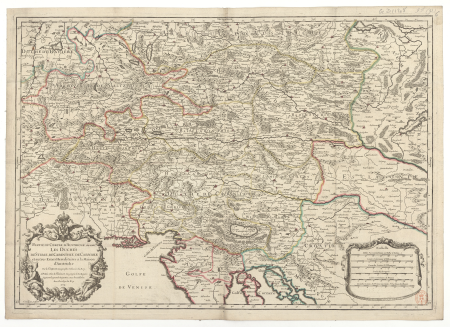
map of the circle of austria by sanson
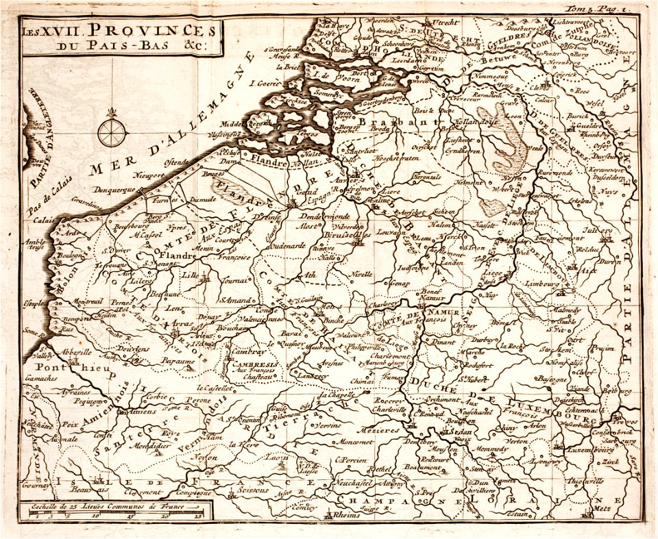
1700s maps of belgium
old maps of lorraine
maps of paris from bibliothèque nationale de france
maps of paris by alexis-hubert jaillot
maps of paris from bibliothèque nationale de france
maps of paris by alexis-hubert jaillot
maps of paris from bibliothèque nationale de france
maps of paris by alexis-hubert jaillot
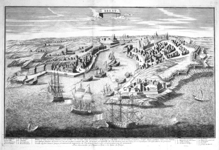
maps of brest, france by antoine aveline
17th-century maps of brest
map of the circle of austria by sanson
1700s maps of austria
maps of alsace by guillaume sanson
maps by alexis-hubert jaillot
map of the circle of the rhineland by sanson
1700s maps of rhineland-palatinate
map of italy by guillaume delisle (1700)
1700s maps of italy
map of the upper rhenian circle by sanson
maps by nicolas sanson
map of the circle of the rhineland by sanson
1700s maps of rhineland-palatinate
maps of brest, france by antoine aveline
brest (france) in the 1700s
18th-century maps of veneto
1700s maps of slovenia
maps by alexis-hubert jaillot
maps by nicolas sanson
maps of alsace by guillaume sanson
1700s maps of alsace
maps of paris from bibliothèque nationale de france
plan de roussel
map of the circle of austria by sanson
1700s maps of austria
18th-century maps of north america
1708 maps of north america
18th-century maps of veneto
1700s maps of slovenia
bibliothèque nationale de france
sanson map of lorraine
map of the upper rhenian circle by sanson
1700s maps of north rhine-westphalia
bibliothèque nationale de france
sanson map of lorraine
bibliothèque nationale de france
sanson map of lorraine
maps of brest from bibliothèque nationale de france
brest (france) in the 1700s
maps of the iberian peninsula by guillaume delisle
1700s maps of the iberian peninsula
antoine-françois tardieu
maps from gallica
map of the circle of austria by sanson
1700s maps of austria
map of the circle of austria by sanson
1700s maps of austria
18th-century maps of veneto
1700s maps of slovenia
sanson maps of the netherlands
robert cordier (engraver)
map of the circle of austria by sanson
1700s maps of austria
maps of the iberian peninsula by guillaume delisle
1700s maps of the iberian peninsula
old maps of the republic of genoa
maps by alexis-hubert jaillot
old maps of the republic of genoa
maps by alexis-hubert jaillot
maps of the iberian peninsula by guillaume delisle
1700s maps of the iberian peninsula
maps of the iberian peninsula by guillaume delisle
1700s maps of the iberian peninsula
map of the upper rhenian circle by sanson
1700s maps of north rhine-westphalia
maps by pieter mortier
maps from gallica
1700s maps of rhineland-palatinate
maps of vangiones by sanson
nicolaes visscher ii
maps from gallica
18th-century maps of corsica
maps by thomas kitchin
map of italy by guillaume delisle (1700)
bibliothèque nationale de france
maps by pieter mortier
maps from gallica
1700s maps of the tsardom of russia
1700s maps of eastern europe
maps by pieter mortier
maps from gallica
a new map of the island of tobago... - by tho.s kitchin... - btv1b53121990k
maps by thomas kitchin
a new map of the island of tobago... - by tho.s kitchin... - btv1b53121990k
maps by thomas kitchin
maps by alexis-hubert jaillot
old maps of duchy of cleves
1700s maps of rhineland-palatinate
maps of east palatinate by sanson
dessin du château de brest
old maps of brest harbours
maps by alexis-hubert jaillot
maps by guillaume sanson
maps by guillaume sanson
maps of galatia
old maps of the kingdom of naples
lago patria
map of europe by guillaume delisle (1700)
bibliothèque nationale de france
maps by pieter mortier
maps from gallica
bibliothèque nationale de france
maps by thomas kitchin
maps by alexis-hubert jaillot
old maps of the tyrol
bibliothèque nationale de france
maps by thomas kitchin
mappe-monde by guillaume delisle (18th century)
1700s maps of the world
maps of paris from the david rumsey historical map collection
map of paris by jouvin de rochefort (boutier 133)
johann stridbeck the younger
old maps of the tyrol
sanson maps of the netherlands
1700s maps of the netherlands
map of the circle of austria by sanson
maps by nicolas sanson
old maps of the kingdom of naples
maps by alexis-hubert jaillot
maps by pieter mortier
maps from gallica
maps by pieter mortier
maps from gallica
bibliothèque nationale de france
maps by thomas kitchin
sanson maps of the circles of germany
bibliothèque nationale de france
map of the bosphorus strait by guillaume sanson (1665)
bibliothèque nationale de france
mappe-monde by guillaume delisle (18th century)
claude auguste berey
map of italy by guillaume delisle (1700)
1700 maps of italy
map of the circle of upper saxony by sanson
1700s maps of saxony
carte de barbarie, nigritie, guinée par guillaume delisle (1707)
bibliothèque nationale de france
old maps of kollam
catherine haussard
bibliothèque nationale de france
maps by thomas kitchin
maps by alexis-hubert jaillot
old maps of the tyrol
bibliothèque nationale de france
sanson map of lorraine
bibliothèque nationale de france
maps by thomas kitchin
carte de l'isle de ceylan by guillaume delisle (1722)
bibliothèque nationale de france
maps by guillaume sanson
old maps of friesland
map of italy by guillaume delisle (1700)
bibliothèque nationale de france
maps by pieter mortier
maps from gallica
le comté de la marck, les seigneuries des abbayes de werden, d'essen et la ville impériale de dortmundt - dressé sur les mémoires les plus récents par le sieur sanson... - btv1b532024306
guillaume sanson
bibliothèque nationale de france
joachim ottens
pierre moullart-sanson
guillaume sanson
sanson maps of the circles of germany
bibliothèque nationale de france
sanson maps of the circles of germany
bibliothèque nationale de france
1750s maps of california
1705 maps of california
old maps of the kingdom of naples
1700s maps of italy
map of ancient armenia by philippe de la rué
bibliothèque nationale de france
18th-century maps of morocco
1700s maps of algeria
maps by thomas kitchin
maps of wales
1700s maps of the netherlands
maps by nicolas sanson
le marquisat et eslectorat de brandebourg qui fait partie du cercle de la haute saxe divisé en ses principales marches... - par le sieur sanson ; cordier sculpsit - btv1b532025368
sanson maps of the circles of germany
map of ancient assyria by philippe de la rué
bibliothèque nationale de france
map of the circle of westfalia by sanson
louis cordier
le duché de poméranie compris sous le cercle de la haute-saxe divisé suivant qu'il est présentement partagé entre la couronne de suède et l'eslecteur de brandebourg, où sont les duchés de... - btv1b53202543b
sanson maps of the circles of germany
1858 photographs of brest (france)
august 1858 in france
atlas géographique des quatre parties du monde (delisle)
map of europe by guillaume delisle (1700)
atlas géographique des quatre parties du monde (delisle)
map of italy by guillaume delisle (1700)
1 - 100 of 116
Next page
/ 2


![Atlantic Ocean or North Sea Where the Route from Europe [sic] to the East Indies and from the West Indies to Europe are exactly observed, Drawn up on the most recent Relations, 1700](https://cdn.creazilla.com/illustrations/10001005747/atlantic-ocean-or-north-sea-where-the-route-from-europe-sic-to-the-east-indies-and-from-the-west-indies-to-europe-are-exactly-observed-drawn-up-on-the-most-recent-relations-1700-md.jpg)


