Log in
All resources
Create a design
27,441 Free Images of Maps
maps of paris from bibliothèque nationale de france
ships on maps
maps by willem and johannes blaeu
bibliothèque nationale de france
classicism
media from the national library of finland
historical aleksanterinkatu project
old maps of helsinki
maps in the national library of finland
national library of finland
ferdinand von wrangel
peter anjou
media from the national library of finland
classicism
maps in the library of congress
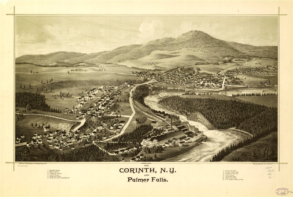
1888 maps of new york (state)
architectonographie des théâtres de paris
maps of paris in the 1830s
maps of austro-prussian war
old maps of croatia
18th-century maps of greenland
old maps of the arctic
historical coats of arms of denmark
ships on maps
maps by john cary
1806 maps of asia
works of nathaniel dearborn
maps of roxbury, boston
latin-language maps
bologna ptolemy
maps from university of amsterdam special collections
atlas der neederlanden
atlas van der hagen (volume 2)
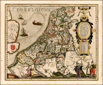
1680s maps of the netherlands
maps of ghardaïa province
maps of ouargla province
cartes de franz schrader
1894 maps of france
old maps of the chesapeake bay
sir walter raleigh
maps from the earth and its inhabitants, vol. x
19th-century maps of the sinai peninsula
maps in the library of congress
novus atlas sinensis
maps by willem and johannes blaeu
17th-century maps of europe
jean étienne guettard
philippe buache
haarlem nautz map 1822-1829
old maps of haarlem
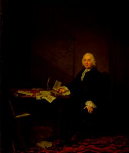
paintings by tibout regters in the rijksmuseum amsterdam
paintings by tibout regters
maps of paris from bibliothèque nationale de france
bird's eye view maps of paris
the generall historie of virginia (john smith)
1624 engravings
16th-century images of algiers
maps of ottoman algeria
jean étienne guettard
philippe buache
engravings
1637
cityscapes of duluth, minnesota
lake freighters
old maps of the united states
copper engravings
victor levasseur - maps of the world
coats of arms of switzerland
magni ducatus lithuaniae
ros' river
media from the national library of finland
classicism
bernhard von breydenbach
erhard reuwich
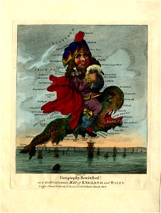
19th-century satirical maps
augusto grossi
1888 maps of texas
texarkana
old maps of the dutch east india company - malaysia
maps of the dutch east india company - indonesia
maps by willem and johannes blaeu
atlas van loon
nicolaas samuel crucquius
old maps of delfland
curt teich postcard archives
postcards of muncie, indiana
maps from traité de la police, bibliothèque nationale de france
fourth map of paris from traité de la police
1673 in new york city
24 august
details of old maps of amsterdam
map of amsterdam, 1544
maps by willem and johannes blaeu
new amsterdam
maps of paris from bibliothèque nationale de france
bird's eye view maps of paris
maps of paris from bibliothèque nationale de france
bird's eye view maps of paris
maps of paris from bibliothèque nationale de france
bird's eye view maps of paris
18th-century maps of antwerp
maps of antwerp city walls
coats of arms of the kingdom of navarre
pales of aragon in heraldry
maps by willem and johannes blaeu
1610s maps of the americas
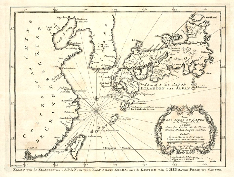
maps of the dutch east india company - korea
maps of the dutch east india company - japan
maps from the earth and its inhabitants, vol. xii
africa in the 1890s
maps of cambridge by braun & hogenberg
1575 maps of england
carte de la mer mediterranée (1764) by roux
eran laor cartographic collection
maps of paris from bibliothèque nationale de france
maps of paris by alexis-hubert jaillot
maps of paris from bibliothèque nationale de france
maps of paris by alexis-hubert jaillot
maps showing 18th-century history
old maps of suriname
1830s maps of switzerland
1834 maps of europe
cornelis danckerts (ii)
1640 maps of italy
media from the national library of finland
classicism
russian empire in thomas kitchen's general atlas (1773)
general atlas (1773)
magni ducatus lithuaniae
1613 maps of europe
17th-century maps of the black sea
maps by willem and johannes blaeu
media from the national library of finland
classicism
maps from the portail des bibliothèques spécialisées de la ville de paris
maps from the bibliothèque historique de la ville de paris
atlas maior, vol 11 (asia) - joan blaeu, 1667 - bl 114.h(star).11
1667 maps
media from the national library of finland
classicism
victor levasseur - maps of france
old maps of meurthe (department)
17th-century maps of africa
maps from gallica
1610s maps of the netherlands
1610s maps of belgium
images of places from encyclopædia britannica
maps of paris in the 1910s
maps in the library of congress
1849 maps of philadelphia
nicolaas samuel crucquius
old maps of delfland
1650s maps of taiwan
1654 maps
media from the national library of finland
classicism
shopping
money
symbol
money
icons
symbol
icons
symbol
1790s maps of central america
1790s maps of cuba
charles v, holy roman emperor
conquest of tunis (1535)
beschrijvinge ende lof der stad haerlem in holland
willem outgertsz. akersloot
media from the national library of finland
classicism
maps by alain manesson-mallet
description de l'universe
satirical prints in the british museum
caricatures of scotland
old maps of the united states
sanson maps of north america
atlas ou representation du monde universel t. 2 (1633)
maps by jan janssonius
gemeente atlas van nederland - north holland
maps of aalsmeer
manual of the corporation of the city of new york (1858)
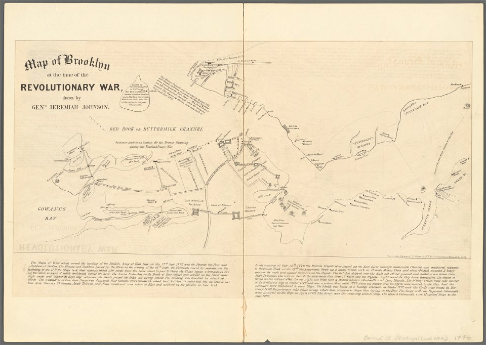
battle of long island
atlas maior, vol 1 (northern europe, norway, and denmark) - joan blaeu, 1667 - bl 114.h(star).1
17th-century double hemisphere world maps
old maps of la rioja (spain)
1769 maps of spain
maps of polders in south holland
old maps of vlaardingen
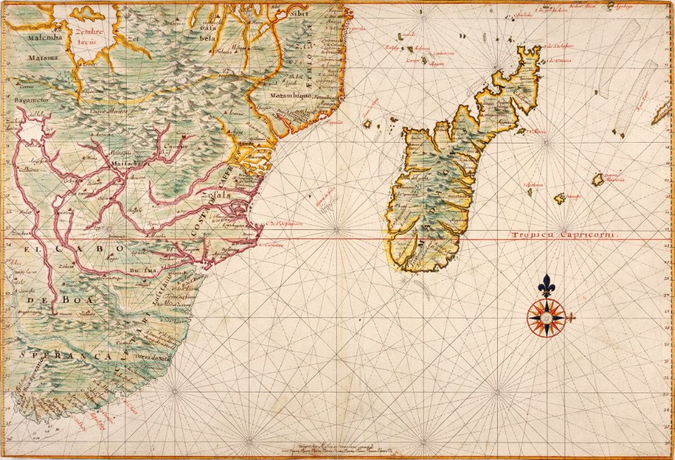
maps of the dutch east india company - mozambique
1660s maps of africa
maps in the rijksmuseum amsterdam
maps by frederick de wit
maps of paris from bibliothèque nationale de france
maps of paris by alexis-hubert jaillot
maps by willem and johannes blaeu
copper engravings
maps of weimar by braun & hogenberg
eran laor cartographic collection
1886 in waco, texas
1886 maps of texas
old maps of cities in texas
maps of fort worth, texas
old maps of cities in texas
maps of paris, texas
gemeente atlas van nederland - south holland
maps of alblasserdam
eran laor cartographic collection
german renaissance,humanism
1301 - 1400 of 27,441
Next page
/ 275