Log in
All resources
Create a design
7,306 Free Images of Geography
physical geography (1899) by davis
géographie générale; physique, politique et économique (1876)
a system of modern geography (1810)
the earth and its inhabitants, vol. ix: asia, vol. iv
nouveau cours d'instruction primaire de géographie (1886)
maps from the earth and its inhabitants, vol. iv
weather maps of the united states
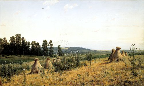
oil on canvas
maps from the earth and its inhabitants, vol. vii
maps from the earth and its inhabitants, vol. ix
géographie générale; physique, politique et économique (1876)
maps of gironde (estuary)
19th-century maps of england and wales
a system of modern geography (1810)
géographie générale; physique, politique et économique (1876)
1876 maps of north america
a system of modern geography (1810)
old maps of the holy land
the earth and its inhabitants, vol. ix: asia, vol. iv
unidentified bridges
a system of modern geography (1810)
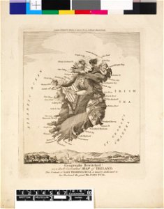
1810s maps of ireland
géographie générale; physique, politique et économique (1876)
old maps of the amazon river
the earth and its inhabitants, vol. ix: asia, vol. iv
a system of modern geography (1810)
1810s maps of china
géographie générale; physique, politique et économique (1876)
19th-century maps of strasbourg
géographie générale; physique, politique et économique (1876)
1870s maps of greece
the earth and its inhabitants, vol. ix: asia, vol. iv
historical images of palmyra
maps from the earth and its inhabitants, vol. ix
sajur river
géographie générale; physique, politique et économique (1876)
1876 maps of italy
géographie générale; physique, politique et économique (1876)
1870s maps of arabia
the earth and its inhabitants, vol. ix: asia, vol. iv
a system of modern geography (1810)
1810 maps of the united states
the earth and its inhabitants, vol. ix: asia, vol. iv
a system of modern geography (1810)
1810s maps of iran
a system of modern geography (1810)
1810s maps of canada
19th-century maps of the malay archipelago
a system of modern geography (1810)
géographie générale; physique, politique et économique (1876)
1870s maps of france
géographie générale; physique, politique et économique (1876)
isotherms (contour lines)
géographie générale; physique, politique et économique (1876)
1876 maps of africa
géographie générale; physique, politique et économique (1876)
1870s maps of england
fur clothing of native people of africa
description de l'universe
20th-century landscape paintings in lillehammer kunstmuseum
paintings by thorvald erichsen in lillehammer kunstmuseum
physical geography (1899) by davis
geological block diagrams
boydell's picturesque scenery of norway (ng.k&h.1979.0056)
olavskirken ruin, bamble
maps from the earth and its inhabitants, vol. xii
1710s maps of africa
maps from the earth and its inhabitants, vol. iv
topographic maps of ireland
maps from the earth and its inhabitants, vol. iv
linguistic maps of wales
maps from the earth and its inhabitants, vol. vii
floods in china
maps from the earth and its inhabitants, vol. vi
alay district
maps from the earth and its inhabitants, vol. vii
treaty ports
maps from the earth and its inhabitants, vol. ix
maps of south india
maps from the earth and its inhabitants, vol. v
maps of sea ice
maps from the earth and its inhabitants, vol. iv
linguistic maps of the united kingdom
maps from the earth and its inhabitants, vol. xi
19th-century maps of chad
maps of weather and climate of the united kingdom
maps from the earth and its inhabitants, vol. iv
maps from the earth and its inhabitants, vol. xiii
maps of orange free state
maps from the earth and its inhabitants, vol. vii
charles eugène perron
maps from the earth and its inhabitants, vol. vi
latin-language maps
maps from the earth and its inhabitants, vol. xvii
maps of u.s. water resource subbasins
maps from the earth and its inhabitants, vol. xvii
anton francesco lucini
maps from the earth and its inhabitants, vol. xiv
1870s maps of new zealand
maps from the earth and its inhabitants, vol. xiv
19th-century maps of borneo
people with kobzas
ostap veresai
realism
polesia
description de l'universe
alexandria in art
the earth and its inhabitants, vol. xii: africa, vol. iii
africa in the 1890s
male portrait paintings by louis-léopold boilly
portrait paintings in the kimbell art museum
satirical prints in the british museum
works after robert dighton
satirical prints in the british museum
works after robert dighton
historical maps of ethnic groups in romania
nouvelle géographie universelle
nouvelle géographie universelle, vol. xiii
engraved illustrations of nature
maps by louis brion de la tour
1761 maps of africa
maps by louis brion de la tour
1761 maps of africa
canyons in iran
eugène flandin
19th-century maps of the indian ocean
physical geography (1899) by davis
physical geography (1899) by davis
1899 maps of europe
physical geography (1899) by davis
cape lookout (north carolina)
physical geography (1899) by davis
maps of narragansett bay
physical geography (1899) by davis
weather maps of the united states
physical geography (1899) by davis
1899 maps of pennsylvania
physical geography (1899) by davis
1899 maps of asia
physical geography (1899) by davis
1899 maps of california
physical geography (1899) by davis
maps of glaciers by country
physical geography (1899) by davis
old maps of the mississippi river
physical geography (1899) by davis
maps of the missouri river
physical geography (1899) by davis
1899 maps of south america
physical geography (1899) by davis
isotherms (contour lines)
nouveau cours d'instruction primaire de géographie (1886)
1880s maps of the americas
physical geography (1899) by davis
1899 maps of africa
physical geography (1899) by davis
weather maps of the united states
physical geography (1899) by davis
1899 maps of africa
physical geography (1899) by davis
1899 maps of india
physical geography (1899) by davis
1899 maps of north america
physical geography (1899) by davis
1899 maps of mexico
nouveau cours d'instruction primaire de géographie (1886)
maps of tahiti
physical geography (1899) by davis
1899 maps of europe
physical geography (1899) by davis
old maps of the mississippi river
physical geography (1899) by davis
maps of crater lake
19th-century maps of the indian ocean
physical geography (1899) by davis
physical geography (1899) by davis
1890s maps of wyoming
physical geography (1899) by davis
weather maps of the united states
nouveau cours d'instruction primaire de géographie (1886)
1886 maps of france
physical geography (1899) by davis
maps of the mississippi river
physical geography (1899) by davis
1899 maps of georgia (u.s. state)
nouveau cours d'instruction primaire de géographie (1886)
1886 maps of france
the earth and its inhabitants, vol. ix: asia, vol. iv
historical images of grand mosque of bursa
maps of the sierra nevada (united states)
physical geography (1899) by davis
physical geography (1899) by davis
old maps of meuse
physical geography (1899) by davis
1899 maps of north america
physical geography (1899) by davis
maps of deception island
physical geography (1899) by davis
1899 maps of asia
physical geography (1899) by davis
maps of ocean currents
nouveau cours d'instruction primaire de géographie (1886)
1886 maps of europe
physical geography (1899) by davis
weather maps of the united states
physical geography (1899) by davis
1899 maps of virginia
1401 - 1500 of 7,306
Next page
/ 74