Log in
All resources
Create a design
67 Free Images of 1798 Maps
maps from university of amsterdam special collections
atlas der neederlanden deel ix: algemeene kaarten & coloniën
maps by jakob van der schley
copperplate print
special collections of the university of amsterdam
jakob van der schley
atlas der neederlanden
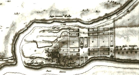
old maps of braunschweig
giovanni maria cassini
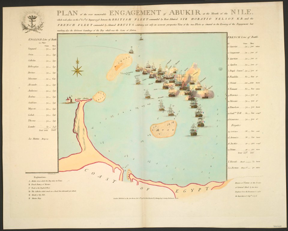
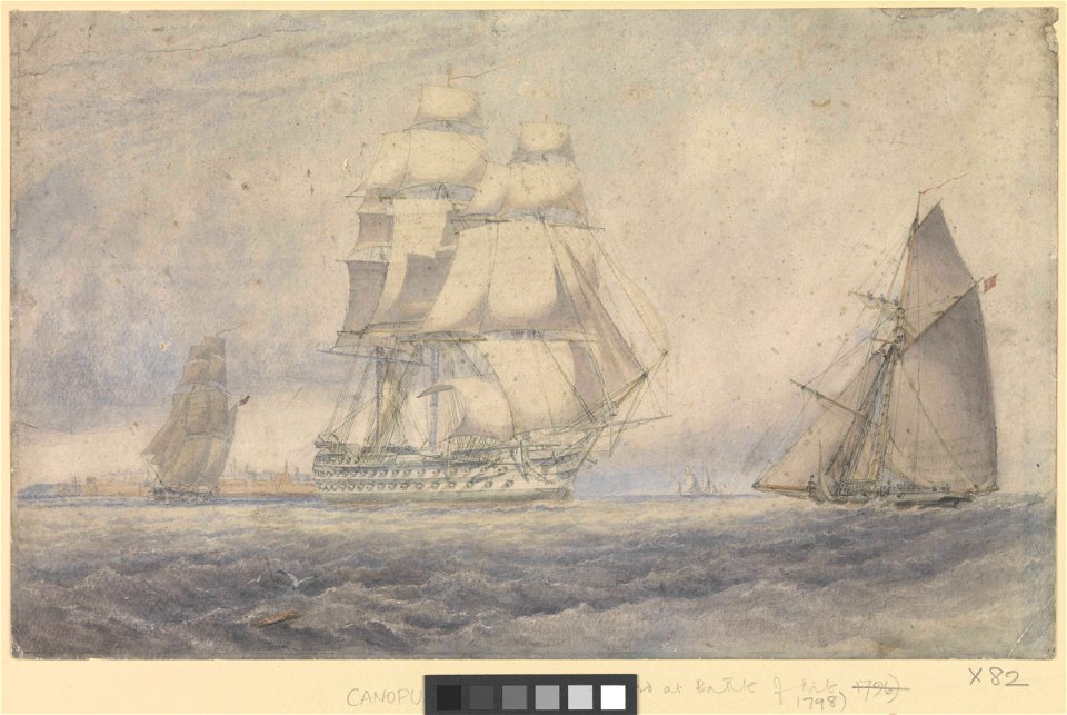
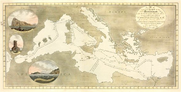
maps of the battle of the nile
a voyage to terra australis
1814 engravings
portrait paintings by élisabeth vigée-lebrun (italian royalty)
portraits of children by élisabeth vigée-lebrun
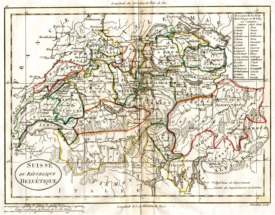
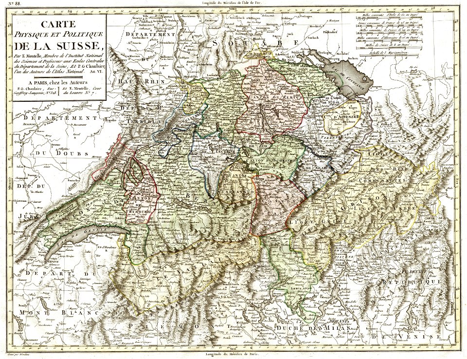
old maps of switzerland
1798 in switzerland
old maps of switzerland
1798 in switzerland
maps of bremen by c. a. heineken
maps made in the 18th century
maps made in the 18th century
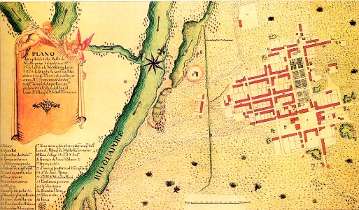
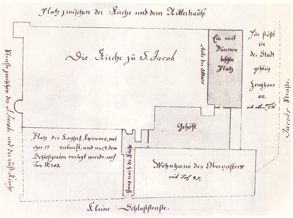
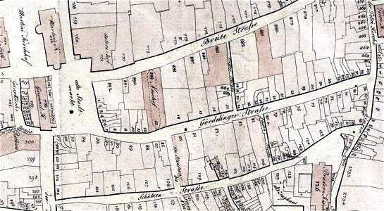
site plans
historical images of słonim
maps of slonim
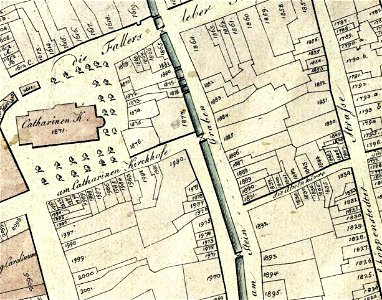
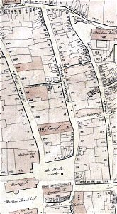
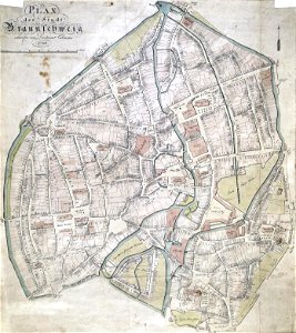
old maps of braunschweig
hutfiltern
old maps of belarus
daugava
johann christoph brotze
riga
old maps of braunschweig
bammelsburg
john brydon (printseller)
thomas vivares
1805 maps of the united states
maps by john cary
1798 in art
printing
collections of stadtarchiv braunschweig
old maps of braunschweig
collections of stadtarchiv braunschweig
old maps of braunschweig
collections of stadtarchiv braunschweig
old maps of braunschweig
collections of stadtarchiv braunschweig
old maps of braunschweig
18th-century engraved oval portraits of men at bust length
joseph banks in art
floor plans of buildings in lower saxony
stadtarchiv lüneburg
printing
1797
printing
london
self-published work
car
architecture
town
old maps of the russian empire
1790s maps of alaska
1790s maps of central america
1790s maps of cuba
maps from university of amsterdam special collections
atlas der neederlanden
daniel friedrich sotzmann
1798 in berlin-mitte
the french invasion of ireland in '98 (1890) by gribayèdoff
maps from the mechanical curator collection
old maps of the batavian republic
cornelis van baarsel
panorama, leicester square
chapels in england
maps in the library of congress
old maps of latin america
antonio carnicero
rococo
prints in the royal collection of the united kingdom
thomas vivares
james weir (royal marines)
battle of the nile
atlas des anciens plans de paris by imprimerie nationale, 1880 from bhvp
proletarian literature
maps from university of amsterdam special collections
atlas der neederlanden
deutsch: italienische nationalbibliothek français : bibliothèque nationale centrale de florence italiano: biblioteca nazionale centrale di firenze
louis albert guislain bacler d'albe
eran laor cartographic collection
pierre françois tardieu
maps from university of amsterdam special collections
atlas der neederlanden
cartouche (cartography)
jean-claude dezauche
maps of hunsrück
jean hardy
eran laor cartographic collection
giovanni maria cassini
eran laor cartographic collection
giovanni maria cassini
1794 rocque wall map of ireland
county clare
maps from university of amsterdam special collections
atlas der neederlanden
maps from university of amsterdam special collections
atlas der neederlanden
maps from university of amsterdam special collections
atlas der neederlanden
maps from university of amsterdam special collections
atlas der neederlanden
maps in the rijksmuseum amsterdam
pieter harmen witkamp
john thomas smith (1766-1833)
clarendon house
maps from university of amsterdam special collections
atlas der neederlanden
maps from university of amsterdam special collections
atlas der neederlanden
maps from university of amsterdam special collections
atlas der neederlanden
atlas der neederlanden deel ix: algemeene kaarten & coloniën
maps from university of amsterdam special collections
maps from university of amsterdam special collections
atlas der neederlanden
maps of the greek colonies
old maps of ancient greece
maps from university of amsterdam special collections
atlas der neederlanden
maps in the rijksmuseum amsterdam
daniël veelwaard (i)
1803 maps of the caribbean
maps by john cary
satirical prints in the british museum
louis-charles ruotte
prints of cartouches in the rijksmuseum amsterdam
maps in the rijksmuseum amsterdam
1806 maps of the united states
maps by john cary
historical collections of the state of new jersey (1852)
1852 maps of the united states
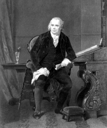
charles balthazar julien févret de saint-mémin
photographs in the new york public library
historical collections of the state of new jersey (1868)
1860s maps of new jersey
alonzo chappel
robert morris
1 - 67 of 67
/ 1


![Map of the Islands of Japan and the peninsula of Korea: with the coasts of China from Peking to Canton / by N. Bellin; J. v. Schley direx, Jakob van der Schley, [1773]](https://cdn.creazilla.com/illustrations/10000188400/map-of-the-islands-of-japan-and-the-peninsula-of-korea-with-the-coasts-of-china-from-peking-to-canton-by-n-bellin-j-v-schley-direx-jakob-van-der-schley-1773-md.jpg)


![[Panorama announcing a View of Windsor ], 1798](https://cdn.creazilla.com/illustrations/10001051501/panorama-announcing-a-view-of-windsor-1798-sm.jpg)


![Persian and Indian Ocean Coastline Map (1740), Jakob van der Schley, [1773]](https://cdn.creazilla.com/illustrations/10001597328/persian-and-indian-ocean-coastline-map-1740-jakob-van-der-schley-1773-sm.jpg)


![Map of Ceylon - European Colonial Establishments, Jakob van der Schley, [1750]](https://cdn.creazilla.com/illustrations/10000562848/map-of-ceylon-european-colonial-establishments-jakob-van-der-schley-1750-sm.webp)


![Persian and Indian Ocean Coastline Map (1740), Jakob van der Schley, [1773]](https://cdn.creazilla.com/illustrations/10000761796/persian-and-indian-ocean-coastline-map-1740-jakob-van-der-schley-1773-md.jpg)
![Map of Hindustan - Bellin, Jakob van der Schley, [1752]](https://cdn.creazilla.com/illustrations/10001359833/map-of-hindustan-bellin-jakob-van-der-schley-1752-md.jpg)
![Map of Java, Sumatra, and Borneo - Nicolas Bellin, Jakob van der Schley, [1773]](https://cdn.creazilla.com/illustrations/10001110266/map-of-java-sumatra-and-borneo-nicolas-bellin-jakob-van-der-schley-1773-md.jpg)
![Persian and Indian Ocean Coastline Map (1740), Jakob van der Schley, [1773]](https://cdn.creazilla.com/illustrations/10001190018/persian-and-indian-ocean-coastline-map-1740-jakob-van-der-schley-1773-sm.jpg)


![Map of Siam, Tonkin, Pegu, Ava, Arakan - J.V.S. Cartography, Jakob van der Schley, [1773]](https://cdn.creazilla.com/illustrations/10001321492/map-of-siam-tonkin-pegu-ava-arakan-j-v-s-cartography-jakob-van-der-schley-1773-sm.jpg)
![New map of the Kingdom of Bengal / J.V. Schley direct, Jakob van der Schley, [1773]](https://cdn.creazilla.com/illustrations/10001347432/new-map-of-the-kingdom-of-bengal-jv-schley-direct-jakob-van-der-schley-1773-md.jpg)
![Map of Table Bay and Cape of Good Hope - J. v. Schley, Jakob van der Schley, [1773]](https://cdn.creazilla.com/illustrations/10000623077/map-of-table-bay-and-cape-of-good-hope-j-v-schley-jakob-van-der-schley-1773-md.jpg)
![Map of Siam, Tonkin, Pegu, Ava, Arakan - J.V.S. Cartography, Jakob van der Schley, [1773]](https://cdn.creazilla.com/illustrations/10001579597/map-of-siam-tonkin-pegu-ava-arakan-j-v-s-cartography-jakob-van-der-schley-1773-md.jpg)
![Carte des costes de Cochin China, Tunquin, et partie de celles de la Chine = Map of the coasts of Cochinchina, of Tunquin, en porseinlyk van de Chineesse-kust / J. v. Schley, Jakob van der Schley, [1773]](https://cdn.creazilla.com/illustrations/10000699035/carte-des-costes-de-cochin-china-tunquin-et-partie-de-celles-de-la-chine-map-of-the-coasts-of-cochinchina-of-tunquin-en-porseinlyk-van-de-chineesse-kust-j-v-schley-jakob-van-der-schley-1773-md.jpg)

![The Empire of China: to serve the history of the European establishment / by N. Bellin ingr. order of the Navy in 1748; J.V. Schley direct, Jakob van der Schley, [1773]](https://cdn.creazilla.com/illustrations/10000709534/the-empire-of-china-to-serve-the-history-of-the-european-establishment-by-n-bellin-ingr-order-of-the-navy-in-1748-j-v-schley-direct-jakob-van-der-schley-1773-md.jpg)