Log in
All resources
Create a design
147 Free Images of 1788 Maps
bibliothèque nationale de france
pompeiana - the topography, edifices, and ornaments of pompeii (1817)
topographisch, oeconomisch und militaerische charte von mecklenburg, schwerin und ratzeburg
topographisch, oeconomisch und militaerische charte des herzogthums mecklenburg schwerin and des fürstenthums ratzeburg - schmettau
english-language maps
an account of the pelew islands
pompeii in art (realistic)
colored engraving on paper
university of texas at arlington
history
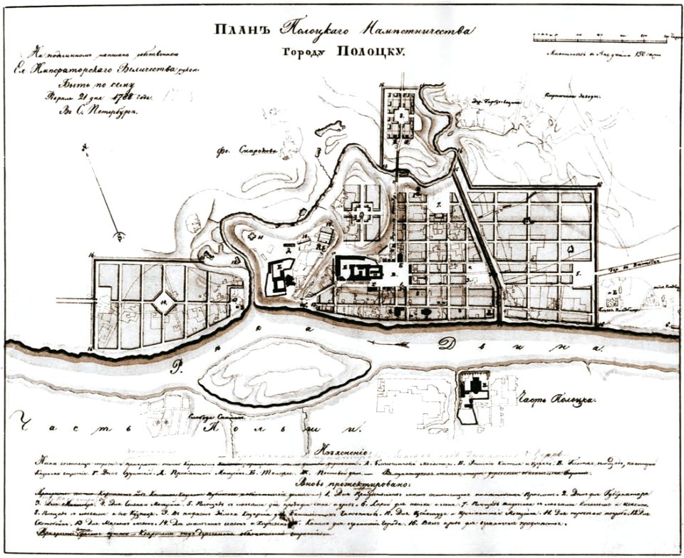
old maps of polotsk
maps in the library of congress
1788 maps of north america
maps in the library of congress
1788 maps of north america
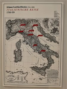
johann gottfried herder
route
charts and maps of the royal museums greenwich
18th-century maps of the mediterranean sea
charts and maps of the royal museums greenwich
18th-century maps of the mediterranean sea
vehicle
car
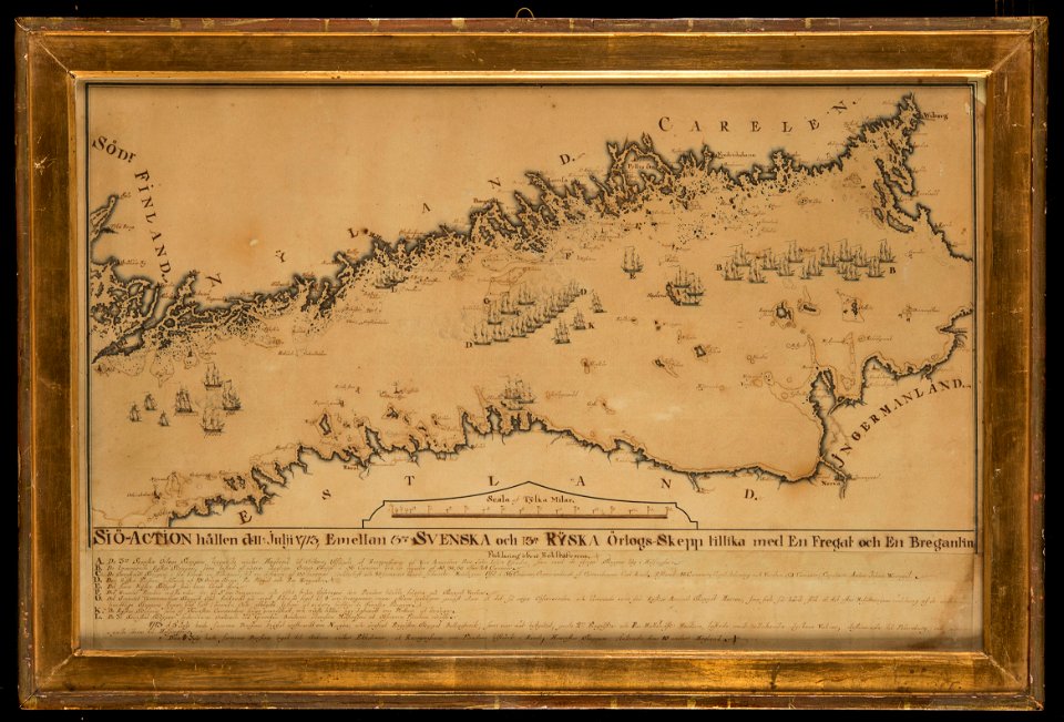
naval battles involving sweden
russo-swedish war (1788–1790)
pavement
facade
architecture
village
1788 maps of the ottoman empire
1788 maps of austria
old maps of seville
1788 maps
national museum of maps and rare books, bucharest
maps of the lower danube
old maps of seville
1788 maps of spain
maps of paris from bibliothèque nationale de france
maps of paris by louis-joseph mondhare
maps of paris from the barry lawrence ruderman antique maps inc.
maps of paris by louis-joseph mondhare
1780s maps of the philippines
old maps of palau
old maps of campania
maps of pompeii
palau in the 18th century
old maps of palau
french-language maps of turkey
1788 maps of turkey
french-language maps of turkey
1788 maps of turkey
map of amsterdam by gerrit de broen (ii)
gerrit de broen
18th-century portrait paintings in the national maritime museum, london
john francis rigaud
palau in the 18th century
old maps of palau
geneviève brossard de beaulieu
jean-françois de la pérouse
maps by daniel lizars
1830s maps of belize
historical
history
1810s maps of the near east
maps by john cary
1810s maps of the near east
maps by john cary
old maps of hispaniola
ambroise tardieu
maps from the mechanical curator collection available to georeference
maps from the mechanical curator collection
1780s maps of the balkans
carl schütz
maps by william home lizars
1836 maps of mexico
maps by william home lizars
1836 maps of mexico
eran laor cartographic collection
giovanni maria cassini
an account of the pelew islands
1788 fleurons
an account of the pelew islands
1788 fleurons
map of europe by guillaume sanson (1674)
bibliothèque nationale de france
eran laor cartographic collection
pierre françois tardieu
russo-turkish war (1787–1792)
old maps of ochakiv
an account of the pelew islands
1788 fleurons
an account of the pelew islands
1788 fleurons
18th-century maps of central america
1760s maps of the caribbean
maps by daniel lizars
1831 maps of mexico
atlante geografico del regno di napoli (1812)
old maps of ariano irpino
eran laor cartographic collection
giovanni maria cassini
maps from university of amsterdam special collections
atlas der neederlanden
ambroise tardieu
hispaniola
the columbian magazine (1788)
pre-raphaelite brotherhood
english-language maps
maps by john cary
franz müller
carl schütz
topographisch, oeconomisch und militaerische charte des herzogthums mecklenburg schwerin and des fürstenthums ratzeburg - schmettau
topographisch, oeconomisch und militaerische charte von mecklenburg, schwerin und ratzeburg
topographisch, oeconomisch und militaerische charte des herzogthums mecklenburg schwerin and des fürstenthums ratzeburg - schmettau
topographisch, oeconomisch und militaerische charte von mecklenburg, schwerin und ratzeburg
topographisch, oeconomisch und militaerische charte des herzogthums mecklenburg schwerin and des fürstenthums ratzeburg - schmettau
topographisch, oeconomisch und militaerische charte von mecklenburg, schwerin und ratzeburg
topographisch, oeconomisch und militaerische charte des herzogthums mecklenburg schwerin and des fürstenthums ratzeburg - schmettau
topographisch, oeconomisch und militaerische charte von mecklenburg, schwerin und ratzeburg
topographisch, oeconomisch und militaerische charte des herzogthums mecklenburg schwerin and des fürstenthums ratzeburg - schmettau
topographisch, oeconomisch und militaerische charte von mecklenburg, schwerin und ratzeburg
topographisch, oeconomisch und militaerische charte des herzogthums mecklenburg schwerin and des fürstenthums ratzeburg - schmettau
topographisch, oeconomisch und militaerische charte von mecklenburg, schwerin und ratzeburg
topographisch, oeconomisch und militaerische charte des herzogthums mecklenburg schwerin and des fürstenthums ratzeburg - schmettau
topographisch, oeconomisch und militaerische charte von mecklenburg, schwerin und ratzeburg
topographisch, oeconomisch und militaerische charte des herzogthums mecklenburg schwerin and des fürstenthums ratzeburg - schmettau
topographisch, oeconomisch und militaerische charte von mecklenburg, schwerin und ratzeburg
topographisch, oeconomisch und militaerische charte des herzogthums mecklenburg schwerin and des fürstenthums ratzeburg - schmettau
topographisch, oeconomisch und militaerische charte von mecklenburg, schwerin und ratzeburg
topographisch, oeconomisch und militaerische charte des herzogthums mecklenburg schwerin and des fürstenthums ratzeburg - schmettau
topographisch, oeconomisch und militaerische charte von mecklenburg, schwerin und ratzeburg
topographisch, oeconomisch und militaerische charte des herzogthums mecklenburg schwerin and des fürstenthums ratzeburg - schmettau
topographisch, oeconomisch und militaerische charte von mecklenburg, schwerin und ratzeburg
topographisch, oeconomisch und militaerische charte des herzogthums mecklenburg schwerin and des fürstenthums ratzeburg - schmettau
topographisch, oeconomisch und militaerische charte von mecklenburg, schwerin und ratzeburg
maps of the course of the rhine by guillaume sanson
bibliothèque nationale de france
topographisch, oeconomisch und militaerische charte des herzogthums mecklenburg schwerin and des fürstenthums ratzeburg - schmettau
topographisch, oeconomisch und militaerische charte von mecklenburg, schwerin und ratzeburg
topographisch, oeconomisch und militaerische charte des herzogthums mecklenburg schwerin and des fürstenthums ratzeburg - schmettau
topographisch, oeconomisch und militaerische charte von mecklenburg, schwerin und ratzeburg
topographisch, oeconomisch und militaerische charte des herzogthums mecklenburg schwerin and des fürstenthums ratzeburg - schmettau
topographisch, oeconomisch und militaerische charte von mecklenburg, schwerin und ratzeburg
topographisch, oeconomisch und militaerische charte des herzogthums mecklenburg schwerin and des fürstenthums ratzeburg - schmettau
topographisch, oeconomisch und militaerische charte von mecklenburg, schwerin und ratzeburg
history
maps
18th-century maps of borneo
1780s maps of indonesia
eran laor cartographic collection
giovanni maria cassini
history
maps
history
maps
maps by william home lizars
1836 maps of texas
maps, prints and photographs in royal danish library
carl wilhelm wiehe
maps by daniel lizars
1831 maps of mexico
history
maps
19th-century oil paintings of landscapes in norway
catharine hermine kølle
british library king's topographical collection
robert dodd
prints by johann esaias nilson in the rijksmuseum amsterdam
maps in the rijksmuseum amsterdam
pompeiana - the topography, edifices, and ornaments of pompeii (1817)
old maps of campania
pompeiana - the topography, edifices, and ornaments of pompeii (1817)
maps of pompeii
viage á constantinopla, en el año de 1784 (1790)
18th-century maps of malta
pompeiana - the topography, edifices, and ornaments of pompeii (1817)
maps of pompeii
pompeiana - the topography, edifices, and ornaments of pompeii (1817)
maps of pompeii
pompeiana - the topography, edifices, and ornaments of pompeii (1817)
house of sallustius (pompeii)
pompeiana - the topography, edifices, and ornaments of pompeii (1817)
historical images of house of sallustius (pompeii)
pompeiana - the topography, edifices, and ornaments of pompeii (1817)
pompeii in art - wall paintings
pompeiana - the topography, edifices, and ornaments of pompeii (1817)
pompeii in art - wall paintings
pompeiana - the topography, edifices, and ornaments of pompeii (1817)
peristylia in art
pompeiana - the topography, edifices, and ornaments of pompeii (1817)
rodwell & martin
pompeiana - the topography, edifices, and ornaments of pompeii (1817)
atriums in art
pompeiana - the topography, edifices, and ornaments of pompeii (1817)
pompeii in art (realistic)
pompeiana - the topography, edifices, and ornaments of pompeii (1817)
historical images of house of diomedes (pompeii)
pompeiana - the topography, edifices, and ornaments of pompeii (1817)
temple of bacchus (pompeii)
pompeiana - the topography, edifices, and ornaments of pompeii (1817)
casa del chirurgo (pompeii)
pompeiana - the topography, edifices, and ornaments of pompeii (1817)
historical images of house of sallustius (pompeii)
pompeiana - the topography, edifices, and ornaments of pompeii (1817)
john le keux
pompeiana - the topography, edifices, and ornaments of pompeii (1817)
pompeiana - the topography, edifices, and ornaments of pompeii (1817)
1 - 100 of 147
Next page
/ 2


![Map of the Nieukoopsche Plas – Land Reclamation (1788), [1791]](https://cdn.creazilla.com/illustrations/10000814135/map-of-the-nieukoopsche-plas-land-reclamation-1788-1791-md.jpg)