Pass map of the coast of Equatorial Guinea, Gabon and Cameroon, Jan Luyken

Pass map of the coast of Equatorial Guinea, Gabon and Cameroon, Jan Luyken

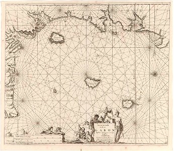
Paskaart van de kust van equatoriaal-guinea, gabon en kameroen, met een kompasroos, het noorden ligt links. Middenonder de titel en het adres van de uitgever, geflankeerd door een man met een verentooi en op zijn arm een papegaai, en een man met apen en een schildpad. Linksonder twee zeegoden bij de schaalverdeling in duitse, spaanse en engelse of franse mijlen (schaal: c. 1:1. 100. 000).;iconclasscode: 25f35(parrot); iconclasscode: 32b321; iconclasscode: 25f22; iconclasscode: 46c24; iconclasscode: 25f44;; print. Object Type: print. Date: 1683 - 1799; 1683 - 1799. Place of creation: Amsterdam. Dimensions: height: 508 mm (20 in)width: 587 mm (23.11 in). Medium: etching, paper. Collection: Rijksmuseum. Paskaart van de kust van Equatoriaal-Guinea, Gabon en Kameroen
Edit image
Published by:
Creazilla
Author: Jan Luyken Johannes van (I) Keulen onbekendSource: commons.wikimedia.org

Loading...

0 downloads
Loading...
old maps of africaold maps of gabondutch 17th-century prints in the rijksmuseum amsterdamengravings of birds in the rijksmuseum amsterdamdutch-language maps of africaprints by jan luyken in the rijksmuseum amsterdametchingpaperrijksmuseumjan luyken

MORE LIKE THIS

Creazilla logo
Over 10 million free graphic resources for content creators and designers.
© 2018 - 2025 Creazilla
Our resourcesAll imagesPhotosDigital illustrationsClipartIconsPNG ImagesEmojisSilhouettesTraditional Art3D ModelsVectorsFontsColor namesColor palettesGradientsAudioAnimationVideosTemplates
InformationAbout CreazillaTerms of useTech teamPrivacy policyLicence Information
FeedbackContact Us