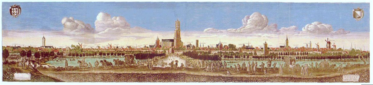
Profile of the city of utrecht seen from the west: the part with the jacobi church and the catharijnepoort. With the following buildings: 1. St. Jobsgasthuis, 2. St. Martinusgasthuis, 3. Weerdpoort, 4. Jacobikerk, 5. Plompetoren, 6. Catharijnepoort, 7. Wittevrouwenklooster, 8. Hertenhuis, 9. Oudaen, 10. Drakenburg, 11. Fresenburg, 12. Blankenburg, 13. Janskerk, 14. Putruwiel, 15. Keyserrijck, 16. Groenewoude, 17. Lichtenberg, 18. Hasenberg (together the town hall), 19. Church of the st. Hieronymusgasthuis, 20. Pieterskerk, 21. Buurkerk, 22. Domkerk, 23. Bisschopshof, 24. Mariakerk, 25 church of st. Paulusabdij, 26. Church of the abraham doleklooster, 27. Chapel of the german house, 28. Church of the regulierenklooster (orphanage), 29. St. Catherine's church, 30. Bartholomeïgasthuis, 31. Smeettoren, 32. Tower of the st. Servaesklooster, 33. Geertekerk, 34. Chapel of the st. Agnietenklooster, 35. Nicolaikerk, 36. Axhewerstoren. Top left the coat of arms of the province of utrecht, top right that of the city of utrecht. Bottom left a miniature city profile of utrecht. Date: between 1 January 1669 and 31 December 1684. Medium: digital reproduction. Collection: Het Utrechts Archief.
Loading...