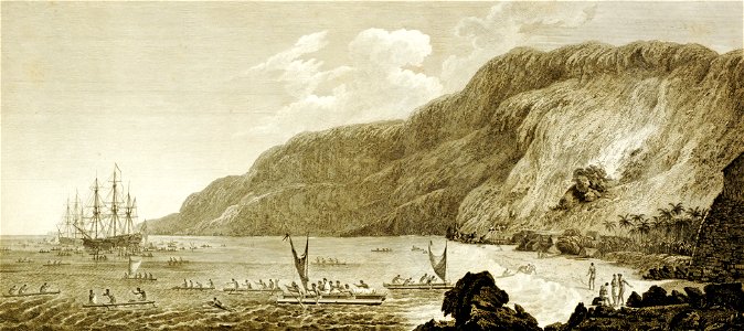
“a view of karakakooa [today’s kealakekua], owhyee”: site of captain cook’s death. From the atlas volume. Karakakooa bay is situated on the west side of the island of owhyhee, in a district called akona. It is about a mile in depth, and bounded by two low points of land, at the distance of half a league, and bearing south south east and north north west from each other. On the north point, which is flat and barren, stands the village of kowrowa; and in the bottom of the bay, near a grove of cocoa-nut trees, there is another village of a more considerable size, called kakooa: between them runs a high rocky cliff, inaccessible from the sea shore. The shore, all round the bay, is covered with a black coral rock, which makes the landing very dangerous in rough weather; except at the village of kakooa, where there is a fine sandy beach, with a morai, or burying-place, at one extremity, and a small well of fresh water, at the other. This bay appearing to captain cook a proper place to refit the ships, and lay in an additional supply of water and provisions, we moored on the north side, about a quarter of a mile from the shore. [vol. 3, pp. 1–2]. Date: 1779.
Loading...