Log in
All resources
Create a design
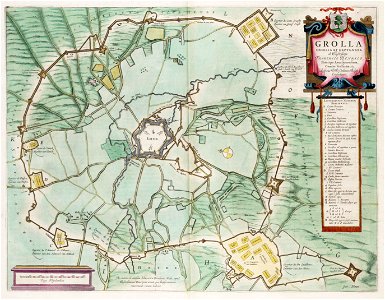
Siege of Grol (Groenlo) 1627 - Grolla Obsessa et Expugnata (J.Blaeu), 1649
Map of the siege of grol (groenlo) in 1627 by frederick henry, prince of orange. Map by j. Blaeu, 1649. Date: 1649.
Download
Edit image
Published by:
Creazilla
Author:
J.Blaeu
Source:
commons.wikimedia.org
Loading...
0 downloads
Print it
Copy image
Loading...
maps by willem and johannes blaeu
siege of groenlo 1627
atlas van loon
old maps of groenlo
circumvallatielinie (groenlo)
engelse schans
coats of arms on maps
investment (military)
siege of groenlo (1627)
defence lines of the netherlands
MORE LIKE THIS