Plan of the City of Santiago, the Capital of Chile. (Plan de la ciudad de Santiago, capital de Chile ), Agostino Aglio, 1824

Plan of the City of Santiago, the Capital of Chile. (Plan de la ciudad de Santiago, capital de Chile ), Agostino Aglio, 1824

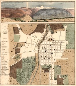
El primer mapa de santiago hecho después de la independencia de chile. Litografía coloreada de agostino aglio no se dice de quién es el boceto en base al que lo hizo; el mapa va acompañado de una vista de los alrededores que incluye un canal del maipo al mapocho; publicada en el libro del viajero y filántropo inglés peter schmidtmeyer travels into chile, over the andes, in the years 1820 and 1821, london: longman, hurst, rees, orme, brown and green, 1824. Date: 1824. Dimensions: 57.5 × 51.2 cm (22.6 × 20.1 in). Medium: lithograph. Collection: John Carter Brown Library. Schmidtmeyer- Aglio, Agostino - Plan of city of Santiago, the capital of Chile -JCB Library f1.1
Edit image
Published by:
Creazilla
Author: Agostino AglioSource: commons.wikimedia.org

Loading...

0 downloads
Loading...
peter schmidtmeyeragostino agliohand-colored lithographs1820s lithographsold maps of santiago de chile1824 in chilelithographjohn carter brown library

MORE LIKE THIS

Creazilla logo
Over 10 million free graphic resources for content creators and designers.
© 2018 - 2025 Creazilla
Our resourcesAll imagesPhotosDigital illustrationsClipartIconsPNG ImagesEmojisSilhouettesTraditional Art3D ModelsVectorsFontsColor namesColor palettesGradientsAudioAnimationVideosTemplates
InformationAbout CreazillaTerms of useTech teamPrivacy policyLicence Information
FeedbackContact Us