Romeyn de Hooghe, Afb 010001000829, Gerard Valck, circa 1754

Romeyn de Hooghe, Afb 010001000829, Gerard Valck, circa 1754

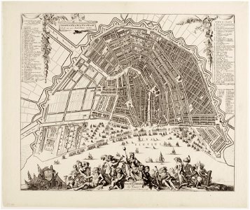
Description amstelodamum cum suis pomoeriis map of amsterdam. Engraved by romeyn de hooghe. 2nd edition. Scale approx. 1:7,250. Published by bernardus cleynhens (kleynhens) in haarlem. For a 1st edition of the map, published by gerard valk (valck), see: saa: 10095/90. Orientation: south-southwest above. Document type: card manufacturer: hooghe, romeyn de cleynhens, bernardus collection: atlas splitgerber collection dating: 1754 ca. Portrayed valk, g. Valck, gerard inventories: http://archief. Amsterdam/archief/10001/34 image file: 010001000829 + - 70% leaflet. Date: circa 1754.
Edit image
Published by:
Creazilla
Author: Romeyn de HoogheSource: commons.wikimedia.org

Loading...

0 downloads
Loading...
maps in the stadsarchief amsterdamromeyn de hooghemaps by gerard valckgerard valck

MORE LIKE THIS

Creazilla logo
Over 10 million free graphic resources for content creators and designers.
© 2018 - 2025 Creazilla
Our resourcesAll imagesPhotosDigital illustrationsClipartIconsPNG ImagesEmojisSilhouettesTraditional Art3D ModelsVectorsFontsColor namesColor palettesGradientsAudioAnimationVideosTemplates
InformationAbout CreazillaTerms of useTech teamPrivacy policyLicence Information
FeedbackContact Us