Map of Roermond, Jacob van Biesen, between 1653 and 1672

Map of Roermond, Jacob van Biesen, between 1653 and 1672

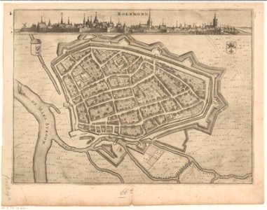
Map of roermond from a bird's-eye perspective. Above the map a view of roermond, seen from outside the city. Top left, in the plan, a crowned coat of arms with a climbing gelderland lion in the right half, the left half of the shield is empty. Top right the coat of arms of roermond. Print also used in: arend van slichthorst (1653-1654) xiv books of the gelderland histories [. . . ] arnhem: jacob van biesen. And in: arend van slichthorst (1672) cartes géographiques du duché de gueldre et comté de zutphen [. . . ] arnhem: jacob van biesen. Date: between 1653 and 1672. Place of creation: Arnhem. Dimensions: height: 25.2 cm (9.9 in); width: 34.6 cm (13.6 in). Medium: etching print and engraving on paper. Depicted Place: Roermond. Collection: Rijksmuseum. Map of Roermond by Nicolaes van Geelkercken Rijksmuseum Amsterdam RP-P-AO-19-66D-1
Edit image
Published by:
Creazilla
Author: Nicolaes van Geelkercken (1585–1656) (printmaker) Jacob van Biesen (1588–1677) (publisher)Source: commons.wikimedia.org

Loading...

0 downloads
Loading...
old maps of roermondroermond in the 17th centurydutch 17th-century prints in the rijksmuseum amsterdammaps in the rijksmuseum amsterdamprints of coats of arms in the rijksmuseum amsterdamjacob van biesenetching print and engraving on paperroermondrijksmuseum

MORE LIKE THIS

Creazilla logo
Over 10 million free graphic resources for content creators and designers.
© 2018 - 2025 Creazilla
Our resourcesAll imagesPhotosDigital illustrationsClipartIconsPNG ImagesEmojisSilhouettesTraditional Art3D ModelsVectorsFontsColor namesColor palettesGradientsAudioAnimationVideosTemplates
InformationAbout CreazillaTerms of useTech teamPrivacy policyLicence Information
FeedbackContact Us