HUA-28600-Plattegrond van de Domtoren te Utrecht op drie niveaus Onder eerste vierkant straatniveau met de onderdoorgang midden eerste vierkant eerste verdiepin, Pieter Jansz. Saenredam

HUA-28600-Plattegrond van de Domtoren te Utrecht op drie niveaus Onder eerste vierkant straatniveau met de onderdoorgang midden eerste vierkant eerste verdiepin, Pieter Jansz. Saenredam

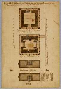
Map of the dom tower in utrecht on three levels. Below: first square - street level (with the underpass), middle: first square - first floor with the michael's chapel, above: first circulation at the foot of the second square. Date: between 1 September 1636 and 30 September 1636. Dimensions: height: 415 cm (13.6 ft); width: 280 cm (110.2 in). Medium: drawing, pen in brown, watercolor. Collection: Het Utrechts Archief.
Edit image
Published by:
Creazilla
Author: Saenredam, P., tekenaar/schilderSource: commons.wikimedia.org

Loading...

0 downloads
Loading...
collection drawings and prints from het utrechts archiefdrawings by pieter jansz. saenredam in het utrechts archiefutrecht dom church by pieter jansz. saenredamdrawingpen in brownwatercolorhet utrechts archiefpieter jansz. saenredam

MORE LIKE THIS

Creazilla logo
Over 10 million free graphic resources for content creators and designers.
© 2018 - 2025 Creazilla
Our resourcesAll imagesPhotosDigital illustrationsClipartIconsPNG ImagesEmojisSilhouettesTraditional Art3D ModelsVectorsFontsColor namesColor palettesGradientsAudioAnimationVideosTemplates
InformationAbout CreazillaTerms of useTech teamPrivacy policyLicence Information
FeedbackContact Us