Historisch Nordamerika, Francis D'Avignon, 1621

Historisch Nordamerika, Francis D'Avignon, 1621

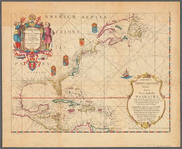
Old map of north america, the caribbean, and northern south america; covers area north from venezuela to labrador; includes decorative cartouches and illustrations. This is a facsimile, from the original on vellum in the collection of e. B. O'callaghan lld. Full title of map: americæ septentrionalis pars: from the west-indische paskaert; waer in de graden der breedde over wederzyden vande middellyn waßende soo vergrooten dat die geproportioneert syn tegen hunne nevenstaende graden der lengde from: o'callaghan, e. B. , ed. (1856) documents relative to the colonial history of the state of new york, i, albany, n. Y. : legislature of the state of new york, opposite title page. Date: 1621.
Edit image
Published by:
Creazilla
Author: Anthoni Jacobsz (1594-1624), cartographerFrancis D'Avignon (1813–1875), lithographer E.B. (Edmund Bailey) O'Callaghan (1797–1880), collectorSource: commons.wikimedia.org

Loading...

0 downloads
Loading...
1620s maps of north america1620s maps of the caribbeanedmund bailey o'callaghanfrancis d'avignon

MORE LIKE THIS

Creazilla logo
Over 10 million free graphic resources for content creators and designers.
© 2018 - 2025 Creazilla
Our resourcesAll imagesPhotosDigital illustrationsClipartIconsPNG ImagesEmojisSilhouettesTraditional Art3D ModelsVectorsFontsColor namesColor palettesGradientsAudioAnimationVideosTemplates
InformationAbout CreazillaTerms of useTech teamPrivacy policyLicence Information
FeedbackContact Us